
Catampacan Hill topographic map
Interactive map
Click on the map to display elevation.
About this map
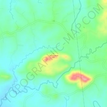
Name: Catampacan Hill topographic map, elevation, terrain.
Location: Catampacan Hill, Bulacan, Central Luzon, Philippines (15.19995 121.08328 15.20005 121.08338)
Average elevation: 78 m
Minimum elevation: 43 m
Maximum elevation: 163 m
Other topographic maps
Click on a map to view its topography, its elevation and its terrain.
Santo Niño
Philippines > Bulacan > Hagonoy
Santo Niño, Hagonoy, Bulacan, Central Luzon, 2017, Philippines
Average elevation: 3 m
Cambio
Philippines > Bulacan > San Miguel
Cambio, San Miguel, Bulacan, Central Luzon, Philippines
Average elevation: 17 m
Look 1st
Philippines > Bulacan > Malolos
Look 1st, Malolos, Bulacan, Central Luzon, 3000, Philippines
Average elevation: 5 m
Marina Lake
Philippines > Bulacan > San Jose del Monte > Sapang Palay Proper
Marina Lake, Sapang Palay Proper, San Jose del Monte, Bulacan, Central Luzon, 3024, Philippines
Average elevation: 50 m
San Roque
Philippines > Bulacan > Baliwag
San Roque, Baliwag, Bulacan, Central Luzon, 3006, Philippines
Average elevation: 12 m
Santa Maria
Santa Maria, Bulacan, Central Luzon, 3022, Philippines
Average elevation: 18 m
Pamarawan
Pamarawan, Bulacan, Central Luzon, 3002, Philippines
Average elevation: 2 m
Cruz na Daan
Philippines > Bulacan > San Rafael
Cruz na Daan, San Rafael, Bulacan, Central Luzon, 3008, Philippines
Average elevation: 19 m
Doña Enriquieta Subdivision
Philippines > Bulacan > Baliwag
Doña Enriquieta Subdivision, Baliwag, Bulacan, Central Luzon, 3006, Philippines
Average elevation: 16 m
San Vicente
San Vicente, Bulacan, Central Luzon, 3011, Philippines
Average elevation: 18 m
San Jose del Monte
San Jose del Monte, Bulacan, Central Luzon, Philippines
Average elevation: 66 m
Longos
Philippines > Bulacan > Calumpit
Longos, Calumpit, Bulacan, Central Luzon, 3000, Philippines
Average elevation: 4 m
Doña Remedios Trinidad
Doña Remedios Trinidad, Bulacan, Central Luzon, Philippines
Average elevation: 172 m
Salacot
Salacot, Bulacan, Central Luzon, 3011, Philippines
Average elevation: 16 m
Balagtas
Balagtas, Bulacan, Central Luzon, 3016, Philippines
Average elevation: 6 m
Marilao
Philippines > Bulacan > Marilao
Marilao, Bulacan, Central Luzon, 3019ALPHA@0MEGA20, Philippines
Average elevation: 7 m
San Jose del Monte
Philippines > Bulacan > San Jose del Monte
San Jose del Monte, Bulacan, Central Luzon, 3023, Philippines
Average elevation: 106 m
Pinagtulayan
Pinagtulayan, Bulacan, Central Luzon, Philippines
Average elevation: 95 m
Meycauayan
Philippines > Bulacan > Meycauayan
Meycauayan, Bulacan, Central Luzon, 3020, Philippines
Average elevation: 27 m
San Rafael
San Rafael, Bulacan, Central Luzon, 3008, Philippines
Average elevation: 32 m
Meycauayan
Meycauayan, Bulacan, Central Luzon, 3020, Philippines
Average elevation: 14 m
Malolos
Malolos, Bulacan, Central Luzon, 3000, Philippines
Average elevation: 6 m
Marilao
Marilao, Bulacan, Central Luzon, 3019, Philippines
Average elevation: 10 m
Ibayong Tabon
Philippines > Bulacan > Ibayong Tabon
Ibayong Tabon, Bulacan, Central Luzon, 3019W, Philippines
Average elevation: 26 m
Pulilan
Philippines > Bulacan > Pulilan
Pulilan, Bulacan, Central Luzon, 3005, Philippines
Average elevation: 10 m
Northville 8 Resettlement
Philippines > Bulacan > Bangkal > Northville 8 Resettlement
Northville 8 Resettlement, Bangkal, Bulacan, Central Luzon, 3015, Philippines
Average elevation: 5 m
Angat
Philippines > Bulacan > Angat
Angat, Bulacan, Central Luzon, 3012, Philippines
Average elevation: 52 m
Bagong Barrio
Philippines > Bulacan > Bagong Barrio
Bagong Barrio, Bulacan, Central Luzon, Philippines
Average elevation: 39 m
Bagong Bayan
Philippines > Bulacan > Bagong Bayan
Bagong Bayan, Bulacan, Central Luzon, 3000, Philippines
Average elevation: 5 m
Bangkal
Philippines > Bulacan > Bangkal
Bangkal, Bulacan, Central Luzon, 3015, Philippines
Average elevation: 5 m
Guiguinto
Philippines > Bulacan > Guiguinto
Guiguinto, Bulacan, Central Luzon, 3015, Philippines
Average elevation: 5 m
Bulakan
Philippines > Bulacan > Bulakan
Bulakan, Bulacan, Central Luzon, 3017, Philippines
Average elevation: 4 m
Dulong Bayan
Philippines > Bulacan > Dulong Bayan
Dulong Bayan, Bulacan, Central Luzon, 3024, Philippines
Average elevation: 53 m
Biak na Bato National Park
Philippines > Bulacan > Doña Remedios Trinidad > Talbak
Biak na Bato National Park, Talbak, Doña Remedios Trinidad, Bulacan, Central Luzon, Philippines
Average elevation: 127 m
Obando
Philippines > Bulacan > Obando
Obando, Bulacan, Central Luzon, 3021, Philippines
Average elevation: 2 m
Tarcan
Philippines > Bulacan > Baliuag > Tarcan
Tarcan, Baliuag, Bulacan, Central Luzon, 3006, Philippines
Average elevation: 13 m
Lias
Philippines > Bulacan > Marilao
Lias, Marilao, Bulacan, Central Luzon, 3019, Philippines
Average elevation: 9 m
Sapang Pare
Philippines > Bulacan > Santo Cristo
Sapang Pare, Santo Cristo, Bulacan, Central Luzon, 3001, Philippines
Average elevation: 4 m
Norzagaray
Norzagaray, Bulacan, Central Luzon, 3013, Philippines
Average elevation: 66 m
Bustos
Philippines > Bulacan > Bustos
Bustos, Bulacan, Central Luzon, 3007, Philippines
Average elevation: 19 m
San Ildefonso
Philippines > Bulacan > San Ildefonso
San Ildefonso, Bulacan, Central Luzon, 3010, Philippines
Average elevation: 17 m
San Miguel
San Miguel, Bulacan, Central Luzon, 3011, Philippines
Average elevation: 22 m
Ibayo
Philippines > Bulacan > Marilao > Ibayo
Ibayo, Marilao, Bulacan, Central Luzon, 3019, Philippines
Average elevation: 6 m
Longos
Philippines > Bulacan > Longos
Longos, Bulacan, Central Luzon, 03016, Philippines
Average elevation: 5 m
Bulakan
Philippines > Bulacan > Bulakan
Bulakan, Bulacan, Central Luzon, 3017, Philippines
Average elevation: 4 m