Geolocate

Davidson County topographic map

Interactive map

Click on the map to display elevation.

Davidson County

Davidson County is located entirely within the Piedmont region of central North Carolina. The Piedmont consists of gently rolling terrain frequently broken by hills or shallow valleys formed by rivers and streams. An exception to this terrain are the Uwharrie Mountains in the county's western and southwestern sections. The Uwharries are the oldest mountain range in North America, and at one time they rose to nearly 20,000 feet (6,100 m) above sea level. However, time has worn them down to little more than high hills; yet due to the relative flatness of the surrounding countryside they still rise from 250 to 500 feet (150 m) above their base. The highest point in the Uwharries - and the highest point in Davidson County - is High Rock Mountain in the county's southwestern corner. It has an elevation of 1,119 feet (341 m) above sea level.

Wikipedia (CC-BY-SA 3.0)

About this map

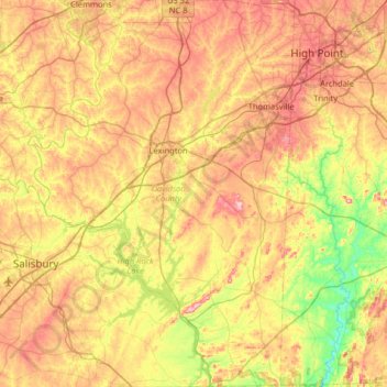
Name: Davidson County topographic map, elevation, terrain.

Location: Davidson County, North Carolina, United States (35.50416 -80.48759 36.02682 -80.04324)

Average elevation: 222 m

Minimum elevation: 111 m

Maximum elevation: 352 m

Other topographic maps

Click on a map to view its topography, its elevation and its terrain.

Appalachian Mountains

United States > North Carolina > Yancey County

The Appalachian Mountains (French: Appalaches), often called the Appalachians, are a system of mountains in eastern to northeastern North America. The Appalachians first formed roughly 480 million years ago during the Ordovician Period. They once reached elevations similar to those of the Alps and the Rocky…

Average elevation: 1,463 m

Concord

United States > North Carolina > Cabarrus County

Concord is located in western Cabarrus County, and has a total area of 60.3 square miles (156.2 km2), of which 0.04 square miles (0.1 km2), or 0.06%, is water. The elevation at the center of downtown is 706 feet (215 m) above sea level.

Average elevation: 201 m

Asheville

United States > North Carolina > Buncombe County

Asheville features a climate that borders between a humid subtropical climate (Köppen Cfa/Trewartha Do) and an oceanic climate (Koppen Cfb) with noticeably cooler temperatures than the rest of the Piedmont region of the Southeast due to the higher elevation; it is part of USDA Hardiness zone 7a. The area's…

Average elevation: 727 m

Forsyth County

United States > North Carolina

The northeast section of Forsyth County, including Belews Creek and parts of Rural Hall, Walkertown, and Kernersville, is drained by tributaries of the Dan River. A small portion of Kernersville is in the Cape Fear River basin. Most of the county is drained by tributaries of the Yadkin River, which forms the…

Average elevation: 258 m

Boone

United States > North Carolina > Watauga County

Boone is located at 36°12′41″N 81°40′7″W / 36.21139°N 81.66861°W / 36.21139; -81.66861 (36.211364, −81.668657) and has an elevation of 3,333 feet (1015.9 m) above sea level. An earlier survey gave the elevation as 3,332 ft and since then it has been published as having an elevation of…

Average elevation: 1,069 m

Waynesville

United States > North Carolina > Haywood County

Most of the town of Waynesville lies between 2,600 and 3,000 feet (790 and 910 m) above sea level, in a valley among 5,000-to-6,410-foot (1,520 to 1,950 m) mountain peaks. With the high Great Balsam Mountains to the west-southwest, and the Plott Balsams to the west-northwest, a handful of peaks over 6000' in…

Average elevation: 921 m

Charlotte

United States > North Carolina > Mecklenburg County

According to the United States Census Bureau, the city has a total area of 308.6 square miles (799 km2), of which 306.6 square miles (794 km2) is land and 2.0 square miles (5.2 km2) is water. Charlotte is the twenty-sixth-most expansive city in the United States and lies at an elevation of 751 feet (229 m).…

Average elevation: 207 m

Highlands

United States > North Carolina > Macon County > Highlands

Highlands was founded in 1875 after its two founders, Samuel Truman Kelsey and Clinton Carter Hutchinson, drew lines from Chicago to Savannah and from New Orleans to New York City. They felt that the place where these lines met would eventually become a great trading center and commercial crossroads. Highlands…

Average elevation: 1,090 m

Murphy

United States > North Carolina > Cherokee County

Murphy has a humid subtropical climate, (Cfa) according to the Köppen classification, with hot, humid summers and cool to mild winters, with low temperatures significantly cooler than other parts of the Southeast, due in part to the elevation. Like the rest of the southeastern U.S., Murphy receives abundant…

Average elevation: 514 m

Ashe County

United States > North Carolina

Average elevation: 952 m

Cabarrus County

United States > North Carolina

Cabarrus County is situated in the gently rolling countryside of the Carolina Piedmont There are no significantly high peaks or points, although the eastern half of the county contains the westernmost foothills of the Uwharrie Mountains. Altitude ranges from approximately 500–800 feet above sea level. No…

Average elevation: 202 m

Yancey County

United States > North Carolina

Average elevation: 968 m

Onslow County

United States > North Carolina

Average elevation: 11 m

Pitt County

United States > North Carolina

Average elevation: 16 m

Buncombe County

United States > North Carolina

Average elevation: 839 m

Guilford County

United States > North Carolina

Average elevation: 239 m

Chatham County

United States > North Carolina

The county lies totally within the Piedmont physiographic region. The topography of the county is generally gently rolling with several higher hills rising above the general terrain. One of these hills, Terrells Mountain, on the Orange County line is the transmitter site for several radio and TV stations for…

Average elevation: 132 m

Sylva

United States > North Carolina > Jackson County

Average elevation: 708 m

Durham County

United States > North Carolina

Average elevation: 128 m

Marion

United States > North Carolina > McDowell County

With an elevation of 1,400 feet, Marion's climate is fairly warm during summer (which are typically longer than lower elevation areas in the United States that get the same average high and low temperatures in the summer), when temperatures tend to be in the 80s and 90s, and moderately cold during the winter,…

Average elevation: 435 m

Blue Ridge Parkway

United States > North Carolina > Watauga County

The parkway has been the most visited unit of the National Park System every year since 1946 except four (1949, 2013, 2016 and 2019).[4][5] Land on either side of the road is owned and maintained by the National Park Service, and in many places parkway land is bordered by United States Forest Service property.…

Average elevation: 505 m

Watauga County

United States > North Carolina

Watauga County is extremely mountainous, and all of the county's terrain is located within the Appalachian Mountains range. The highest point in the county is Calloway Peak, the highest peak of Grandfather Mountain (shared with the adjacent counties of Avery and Caldwell), which rises to 5,964 feet (1,818…

Average elevation: 984 m

Cherokee County

United States > North Carolina

Cherokee County is the westernmost county in the U.S. state of North Carolina. It borders Tennessee to its west and Georgia to its south. As of the 2010 census, the population was 27,444. The county seat is Murphy, population 1,627 (2010), elevation 1604 ft.

Average elevation: 655 m

Apex

United States > North Carolina > Wake County

Average elevation: 115 m

Pender County

United States > North Carolina

Average elevation: 12 m

Mount Mitchell

United States > North Carolina > Yancey County

Mount Mitchell, known in Cherokee as Attakulla, is the highest peak of the Appalachian Mountains and the highest peak in mainland eastern North America. It is located near Burnsville in Yancey County, North Carolina in the Black Mountain subrange of the Appalachians about 19 miles (31 km) northeast of…

Average elevation: 1,743 m

Dare County

United States > North Carolina

Average elevation: 1 m

Stokes County

United States > North Carolina

Average elevation: 294 m

Knightdale

United States > North Carolina > Wake County

Knightdale is located in the northeast central region of North Carolina, where the North American Piedmont and Atlantic Coastal Plain regions meet. This area is known as the "Fall Line" because it marks the elevation inland at which waterfalls begin to appear in creeks and rivers. Its central Piedmont location…

Average elevation: 84 m

Rowan County

United States > North Carolina

Average elevation: 228 m

Transylvania County

United States > North Carolina

Transylvania County is known as the "Land of Waterfalls", due to it having over 250 waterfalls. This is due to a combination of its high precipitation and location on the Blue Ridge Escarpment. Notable waterfalls in the county include Looking Glass Falls, Moore Cove Falls, Rainbow Falls, and Whitewater Falls,…

Average elevation: 898 m