
Weber County topographic map
Interactive map
Click on the map to display elevation.
About this map
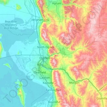
Name: Weber County topographic map, elevation, terrain.
Location: Weber County, Utah, United States (41.07684 -112.49348 41.43393 -111.42038)
Average elevation: 1,722 m
Minimum elevation: 1,278 m
Maximum elevation: 2,919 m
The county extends from high in the Wasatch Range in the east into a portion of the Great Salt Lake to the west, where the county's elongated point exists. The Weber and Ogden rivers and their tributaries run through its valleys. The Weber County Surveyor's office divides the county into two regions, the "Lower Valley" and the "Upper Valley", divided by the ridge of the Wasatch front range south through the county. Lower Valley, adjacent to the Lake, is the county's more populous part. The Upper Valley consists mostly of the Ogden Valley, the watershed of the Ogden River. The county's highest elevation is Willard Peak in the Wasatch Mountains, at 9,763' (2976m) ASL. The county has an area of 659 square miles (1,710 km2), of which 576 square miles (1,490 km2) is land and 83 square miles (210 km2) (13%) is water. It is the second-smallest county in Utah by land area and third-smallest by total area.
Other topographic maps
Click on a map to view its topography, its elevation and its terrain.
Cedar City
United States > Utah > Iron County
Cedar City, Iron County, Utah, United States
Average elevation: 1,975 m
Provo
United States > Utah > Utah County
Provo, Utah County, Utah, United States
Average elevation: 1,728 m
Park City
United States > Utah > Summit County
Park City, Summit County, Utah, United States
Average elevation: 2,290 m
Moab
United States > Utah > Grand County
Moab, Grand County, Utah, 84532, United States
Average elevation: 1,357 m
Ogden
United States > Utah > Weber County
Ogden, Weber County, Utah, United States
Average elevation: 1,498 m
Providence Canyon
United States > Utah > Cache County
Providence Canyon, Cache County, Utah, 84332, United States
Average elevation: 1,829 m
Virgin
United States > Utah > Washington County
Virgin, Washington County, Utah, United States
Average elevation: 1,251 m
Woodland Hills
United States > Utah > Utah County
Woodland Hills, Utah County, Utah, United States
Average elevation: 1,812 m
Farr West
United States > Utah > Weber County
Farr West, Weber County, Utah, United States
Average elevation: 1,313 m
Fruitland
United States > Utah > Duchesne County
Fruitland, Duchesne County, Utah, 84027, United States
Average elevation: 2,028 m
Saratoga Springs
United States > Utah > Utah County
Saratoga Springs, Utah County, Utah, 84045, United States
Average elevation: 1,500 m
Mount Timpanogos
United States > Utah > Utah County
Mount Timpanogos, Utah County, Utah, 84602, United States
Average elevation: 3,139 m
Echo
United States > Utah > Summit County
Echo, Summit County, Utah, 84024, United States
Average elevation: 1,792 m
Elk Ridge
United States > Utah > Utah County
Elk Ridge, Utah County, Utah, United States
Average elevation: 1,698 m
Draper
United States > Utah > Salt Lake County
Draper, Salt Lake County, Utah, 84020, United States
Average elevation: 1,573 m
Springdale
United States > Utah > Washington County
Springdale, Washington County, Utah, 84767, United States
Average elevation: 1,354 m
Bryce Canyon National Park
United States > Utah > Garfield County
Bryce Canyon National Park, Garfield County, Utah, United States
Average elevation: 2,259 m
Malad River
United States > Utah > Box Elder County
Malad River, Box Elder County, Utah, 84301, United States
Average elevation: 1,295 m
Bel-Mar Acres
United States > Utah > Weber County > South Ogden
Bel-Mar Acres, South Ogden, Weber County, Utah, 84408, United States
Average elevation: 1,375 m
Upheaval Dome
United States > Utah > San Juan County
Upheaval Dome, San Juan County, Utah, United States
Average elevation: 1,627 m
Halchita
United States > Utah > San Juan County
Halchita, San Juan County, Utah, United States
Average elevation: 1,398 m
Washington County
Washington County, Utah, United States
Average elevation: 1,550 m
Price
United States > Utah > Carbon County
Price, Carbon County, Utah, 84591, United States
Average elevation: 1,711 m
Centerville
United States > Utah > Davis County
Centerville, Davis County, Utah, 84014, United States
Average elevation: 1,521 m
Riverton
United States > Utah > Salt Lake County
Riverton, Salt Lake County, Utah, United States
Average elevation: 1,376 m
Townsend
United States > Utah > Utah County > Genola
Townsend, Genola, Utah County, Utah, 84655, United States
Average elevation: 1,438 m
Manns Peak
United States > Utah > Grand County
Manns Peak, Grand County, Utah, United States
Average elevation: 3,427 m
Castle Valley
United States > Utah > Grand County
Castle Valley, Grand County, Utah, United States
Average elevation: 1,610 m
Castleton Tower
United States > Utah > Grand County
Castleton Tower, Grand County, Utah, United States
Average elevation: 1,549 m
Black Mountain
United States > Utah > Salt Lake County > Salt Lake City
Black Mountain, Salt Lake City, Salt Lake County, Utah, United States
Average elevation: 2,250 m
Black Mountain
United States > Utah > Rich County
Black Mountain, Rich County, Utah, United States
Average elevation: 2,157 m
Salina
United States > Utah > Sevier County
Salina, Sevier County, Utah, 84654, United States
Average elevation: 1,637 m
Pleasant View
United States > Utah > Utah County > Provo
Pleasant View, Provo, Utah County, Utah, 84604, United States
Average elevation: 1,446 m
Summit Park
United States > Utah > Summit County
Summit Park, Summit County, Utah, United States
Average elevation: 2,152 m
Colorado Plateau
United States > Utah > San Juan County
Colorado Plateau, San Juan County, Utah, United States
Average elevation: 1,512 m
Coalville
United States > Utah > Summit County
Coalville, Summit County, Utah, United States
Average elevation: 1,825 m
Heber
United States > Utah > Wasatch County
Heber, Wasatch County, Utah, 84032, United States
Average elevation: 1,737 m
Salt Lake City
United States > Utah > Salt Lake County
Salt Lake City, Salt Lake County, Utah, United States
Average elevation: 1,592 m
Mountains Meadows
United States > Utah > Davis County > North Salt Lake
Mountains Meadows, North Salt Lake, Davis County, Utah, 84054, United States
Average elevation: 1,411 m
West Haven
United States > Utah > Weber County
West Haven, Weber County, Utah, United States
Average elevation: 1,310 m
Holladay
United States > Utah > Salt Lake County
Holladay, Salt Lake County, Utah, 84124, United States
Average elevation: 1,425 m
Saint George
United States > Utah > Washington County
Saint George, Washington County, Utah, United States
Average elevation: 929 m
Aneth
United States > Utah > San Juan County
Aneth, Shiprock Agency, San Juan County, Utah, United States
Average elevation: 1,422 m
South Jordan
United States > Utah > Salt Lake County
South Jordan, Salt Lake County, Utah, 84095, United States
Average elevation: 1,407 m