
Scotland topographic map
Click on the map to display elevation.
Scotland
Scotland's topography is a tapestry of rugged mountains, rolling hills, and expansive coastlines. The Highlands, occupying the northern and western regions, are characterized by towering peaks such as Ben Nevis, the UK's highest at 1,345 meters, and deep glens carved by ancient glaciers. The Grampian Mountains, including the Cairngorms, present a mix of rounded summits and plateaus, offering a stark contrast to the jagged Cuillin range on the Isle of Skye. Southward, the Central Lowlands, or Midland Valley, feature undulating hills and fertile plains, while the Southern Uplands boast gentle, rolling hills that descend towards the Solway Firth. Scotland's extensive coastline is deeply indented with sea lochs and dotted with numerous islands, each displaying unique geological features. This diverse terrain not only shapes the country's natural beauty but also influences its climate, vegetation, and human settlement patterns.
About this map
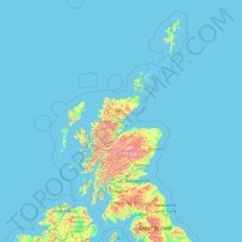
Name: Scotland topographic map, elevation, terrain.
Location: Scotland, United Kingdom (54.43398 -14.01552 61.06100 -0.32092)
Average elevation: 36 m
Minimum elevation: 0 m
Maximum elevation: 1,259 m
United Kingdom trails, hiking, mountain biking, running and outdoor activities
Other topographic maps
Click on a map to view its topography, its elevation and its terrain.
United Kingdom
Scotland accounts for just under a third (32 per cent) of the total area of the UK, covering 78,772 square kilometres (30,410 sq mi). This includes nearly eight hundred islands, predominantly west and north of the mainland; notably the Hebrides, Orkney Islands and Shetland Islands. Scotland is the most…
Average elevation: 79 m
Glasgow
United Kingdom > Scotland > Glasgow City
Glasgow itself was reputed to have been founded by the Christian missionary Saint Mungo in the 6th century. He established a church on the Molendinar Burn, where the present Glasgow Cathedral stands, and in the following years Glasgow became a religious centre. Glasgow grew over the following centuries. The…
Average elevation: 128 m
Edinburgh
United Kingdom > Scotland > Edinburgh
Some have called Edinburgh the Athens of the North for a variety of reasons. The earliest comparison between the two cities showed that they had a similar topography, with the Castle Rock of Edinburgh performing a similar role to the Athenian Acropolis. Both of them had flatter, fertile agricultural land…
Average elevation: 104 m
Aberdeen
United Kingdom > Scotland > Aberdeen
Two weather stations collect climate data for the area, Aberdeen/Dyce Airport, and Craibstone. Both are about 4 1⁄2 miles (7 km) to the north west of the city centre, and given that they are in close proximity to each other, exhibit very similar climatic regimes. Dyce tends to have marginally warmer daytime…
Average elevation: 52 m
Brund Fell (summit)
United Kingdom > England > Cumberland > Borrowdale
The fell has a summit plateau which consist of many heather-covered hummocks, drystone walls and clumps of trees. Well-known Lake District writer Alfred Wainwright credits Grange Fell as a single fell with three main summits, namely Brund Fell, King's How and Ether Knott. The lesser known Ether Knott is now…
Average elevation: 252 m
Snowdon
United Kingdom > Wales > Gwynedd
Snowdon (/ˈsnoʊdən/) or Yr Wyddfa (pronounced [ər ˈʊɨ̞̯ðva] (listen)), is the highest mountain in Wales, at an elevation of 1,085 metres (3,560 ft) above sea level, and the highest point in the British Isles outside the Scottish Highlands. It is located in Snowdonia National Park (Parc Cenedlaethol…
Average elevation: 692 m
City of London
United Kingdom > England > City of London > City of London
The elevation of the City ranges from sea level at the Thames to 21.6 metres (71 ft) at the junction of High Holborn and Chancery Lane. Two small but notable hills are within the historic core, Ludgate Hill to the west and Cornhill to the east. Between them ran the Walbrook, one of the many "lost" rivers or…
Average elevation: 42 m
St Albans
United Kingdom > England > Hertfordshire > St Albans
St Albans was an ancient borough created following the dissolution of the monastery in 1539. It consisted of the ancient parish of St Albans (also known as the Abbey parish) and parts of St Michael and St Peter. The municipal corporation was reformed by the Municipal Corporations Act 1835 and the boundary was…
Average elevation: 100 m
Cambridge
United Kingdom > England > Cambridge
The city, like most of the UK, has a maritime climate highly influenced by the Gulf Stream. Located in the driest region of Britain, Cambridge's rainfall averages around 570 mm (22.44 in) per year, around half the national average, with some years occasionally falling into the semi-arid (under 500 mm (19.69…
Average elevation: 18 m
Stoke-on-Trent
United Kingdom > England > Stoke-on-Trent > Stoke-on-Trent
In 1919, the borough proposed to expand further and annex the neighbouring borough of Newcastle-under-Lyme and the Wolstanton United Urban District, both to the west of Stoke. This never took place, due to strong objections from Newcastle Corporation. A further attempt was made in 1930, with the promotion of…
Average elevation: 160 m
Peterborough
United Kingdom > England > Cambridgeshire
The local topography is flat, and in some places, the land lies below sea level, for example in parts of the Fens to the east and to the south of Peterborough. Human settlement in the area began before the Bronze Age, as can be seen at the Flag Fen archaeological site to the east of the current city centre,…
Average elevation: 17 m
Bradford
Bradford is located at 53°45′00″N 01°50′00″W / 53.75000°N 1.83333°W / 53.75000; -1.83333 (53.7500, -1.8333)1. Topographically, it is located in the eastern moorland region of the South Pennines.
Average elevation: 167 m
Bottomhouse
United Kingdom > England > Staffordshire > Staffordshire Moorlands > Ipstones
Average elevation: 312 m
Scottish Highlands
United Kingdom > Scotland > Highland
The Scottish Highlands are renowned for their rugged, mountainous terrain that dominates much of the region. Stretching across the northern and central parts of Scotland, the landscape is shaped by ancient geological forces, including the Caledonian Orogeny, which caused significant tectonic collisions…
Average elevation: 907 m
Darwen
United Kingdom > England > Darwen
Much of the town was built between about 1850 and 1900; placenames, date stones in terraces, and the vernacular architecture of cellars, local stone, locally-made brick, pipework and tiles and leaded glass, the last now mostly gone, reflect this. It was one of the first places in the world to have steam trams.…
Average elevation: 241 m
Pennines
United Kingdom > England > Westmorland and Furness
The Pennine climate is generally temperate like that of the rest of England, but the hills have more precipitation, stronger winds and colder weather than the surrounding areas. Higher elevations have a tundra climate. More snow falls on the Pennines than on surrounding lowland areas due to the elevation and…
Average elevation: 761 m
Farnborough
United Kingdom > England > Hampshire > Rushmoor
Farnborough is located in the northeastern corner of the county of Hampshire, near the border with Surrey. The town occupies a valley setting, with the main urban area situated between the River Blackwater to the east and higher ground to the west. The topography gradually rises from the valley floor, reaching…
Average elevation: 82 m
Swansea
United Kingdom > Wales > Swansea
Much of Swansea is hilly with the main area of upland being located in the council ward of Mawr. Areas up to 185 metres (607 ft) in elevation range across the central section: Kilvey Hill, Townhill and Llwynmawr separate the centre of Swansea from its northern suburbs. Cefn Bryn, a ridge of high land, is the…
Average elevation: 73 m
Hull
United Kingdom > England > Kingston upon Hull
Kingston upon Hull is on the northern bank of the Humber Estuary. The city centre is west of the River Hull and close to the Humber. The city is built upon alluvial and glacial deposits which overlie chalk rocks but the underlying chalk has no influence on the topography. The land within the city is generally…
Average elevation: 21 m
Plymouth
United Kingdom > England > Devon > Plymouth
The River Plym, which flows off Dartmoor to the north-east, forms a smaller estuary to the east of the city called Cattewater. Plymouth Sound is protected from the sea by the Plymouth Breakwater, in use since 1814. In the Sound is Drake's Island which is seen from Plymouth Hoe, a flat public area on top of…
Average elevation: 81 m
Gateshead
United Kingdom > England > Tyne and Wear > Gateshead
One of the most distinguishing features of Gateshead is its topography. The land rises 230 feet (70 m) from Gateshead Quays to the town centre and continues rising to a height of 525 feet (160 m) at Queen Elizabeth Hospital in Sheriff Hill. This is in contrast to the flat and low lying Team Valley located on…
Average elevation: 62 m
Leeds
Lying in the eastern foothills of the Pennines, there is a significant variation in elevation within the city's built-up area. The district ranges from 1,115 feet (340 m) in the far west on the slopes of Ilkley Moor to about 33 feet (10 m) where the rivers Aire and Wharfe cross the eastern boundary. Land rises…
Average elevation: 94 m
Napton on the Hill
United Kingdom > England > Warwickshire > Stratford-on-Avon
Average elevation: 113 m