
Make a donation
Gear up for your next adventure:
As an Amazon Associate, this site earns from qualifying purchases at no extra cost to you.
Diamer District topographic map
Click on the map to display elevation.
Make a donation
Gear up for your next adventure:
As an Amazon Associate, this site earns from qualifying purchases at no extra cost to you.
About this map
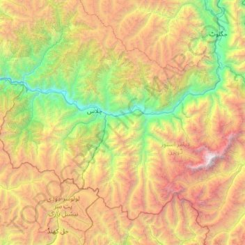
Name: Diamer District topographic map, elevation, terrain.
Average elevation: 3,399 m
Minimum elevation: 958 m
Maximum elevation: 8,084 m
Make a donation
Gear up for your next adventure:
As an Amazon Associate, this site earns from qualifying purchases at no extra cost to you.
Other topographic maps
Click on a map to view its topography, its elevation and its terrain.
K2
Pakistan > Gilgit-Baltistan > Shigar District
K2 is the only 8,000+ metre peak that has never been climbed from its eastern face. Ascents have almost always been made in July and August, which are typically the warmest times of the year; K2's more northern location makes it more susceptible to inclement and colder weather. The peak has now been climbed by…
Average elevation: 7,474 m
Skardu
Pakistan > Gilgit-Baltistan > Skardu District
Skardu (Balti: སྐར་མདོ་་; Urdu: سکردو, romanized: skardū, pronounced [skərduː]) is a city located in Pakistani-administered Gilgit−Baltistan in the disputed Kashmir region. Skardu serves as the capital of Skardu District and the Baltistan Division. It is situated at an average…
Average elevation: 3,423 m
Gilgit
Pakistan > Gilgit-Baltistan > Gilgit District
Gilgit lacks significant rainfall, averaging in 120 to 240 mm (4.7 to 9.4 in) annually, as monsoon breaks against the southern range of Himalayas. Irrigation for land cultivation is obtained from the rivers, abundant with melting snow water from higher altitudes.
Average elevation: 3,002 m
Nanga Parbat
Pakistan > Gilgit-Baltistan > Astore District
To the south, Nanga Parbat has what is often referred to as the highest mountain face in the world: the Rupal Face rises 4,600 m (15,090 ft) above its base. To the north, the complex, somewhat more gently sloped Rakhiot Flank rises 7,000 m (23,000 ft) from the Indus River valley to the summit in just 25 km (16…
Average elevation: 7,086 m
Make a donation
Gear up for your next adventure:
As an Amazon Associate, this site earns from qualifying purchases at no extra cost to you.
K2
Pakistan > Gilgit-Baltistan > Shigar District
K2 is nicknamed "The King of Mountains" and "The Mountaineers' Mountain", as well as "The Mountain of Mountains", a phrase popularized by Italian climber Reinhold Messner in his book on K2. Although the summit of Everest is at a higher altitude, K2 is a more difficult and dangerous climb. This is in part due…
Average elevation: 7,474 m
Gilgit
Pakistan > Gilgit-Baltistan > Gilgit District
Gilgit lacks significant rainfall, averaging in 120 to 240 mm (4.7 to 9.4 in) annually, as monsoon breaks against the southern range of Himalayas. Irrigation for land cultivation is obtained from the rivers, abundant with melting snow water from higher altitudes.
Average elevation: 3,002 m
Make a donation
Gear up for your next adventure:
As an Amazon Associate, this site earns from qualifying purchases at no extra cost to you.
K2
Pakistan > Gilgit-Baltistan > Shigar District
K2 is the only 8,000+ metre peak that has never been climbed from its eastern face. Ascents have almost always been made in July and August, which are typically the warmest times of the year; K2's more northern location makes it more susceptible to inclement and colder weather. The peak has now been climbed by…
Average elevation: 7,474 m
Make a donation
Gear up for your next adventure:
As an Amazon Associate, this site earns from qualifying purchases at no extra cost to you.
Junction of Three Highest Mountains Range
Pakistan > Gilgit-Baltistan > Gilgit District > Juglot Tehsil
Average elevation: 1,440 m
Make a donation
Gear up for your next adventure:
As an Amazon Associate, this site earns from qualifying purchases at no extra cost to you.
Ultar Peak
Pakistan > Gilgit-Baltistan > Hunza District
The first two summits were made in 1996 by two separate Japanese expeditions, the first on 11 July from the Tokai section of the Japanese Alpine Club led by Akito Yamazaki, and the second led by Ken Takahashi. The first summit team comprised Yamazaki and Kiyoshi Matsuoka (who died one year later on the nearby…
Average elevation: 6,458 m
Make a donation
Gear up for your next adventure:
As an Amazon Associate, this site earns from qualifying purchases at no extra cost to you.
Masherbrum
Pakistan > Gilgit-Baltistan > Shigar District
Masherbrum (Urdu: مشہ بروم ; formerly known as K1) is a mountain located in the Ghanche District in the Gilgit Baltistan region of Pakistan. With an elevation of 7,821 metres (25,659 feet), it ranks as the 22nd highest mountain globally and the 9th highest in Pakistan. It holds the distinction of being…
Average elevation: 6,469 m
Saltoro Kangri
Pakistan > Gilgit-Baltistan > Ghanche District
The mountain underwent reconnaissance by Fanny Bullock Workman and her husband in 1911-12. The initial endeavor to conquer the peak, which was then denoted as "Peak 36," took place in 1935, led by a British expedition headed by James Waller and John Hunt. Hunt's involvement in the expedition had been suggested…
Average elevation: 6,651 m
Make a donation
Gear up for your next adventure:
As an Amazon Associate, this site earns from qualifying purchases at no extra cost to you.
Make a donation
Gear up for your next adventure:
As an Amazon Associate, this site earns from qualifying purchases at no extra cost to you.
Saltoro Kangri
Pakistan > Gilgit-Baltistan > Ghanche District
The mountain underwent reconnaissance by Fanny Bullock Workman and her husband in the year 1911-12. The initial endeavor to conquer the peak, which was then denoted as "Peak 36," took place in 1935, led by a British expedition headed by James Waller and John Hunt. Hunt's involvement in the expedition had been…
Average elevation: 6,651 m
Make a donation
Gear up for your next adventure:
As an Amazon Associate, this site earns from qualifying purchases at no extra cost to you.
K2
Pakistan > Gilgit-Baltistan > Shigar District
Also occasionally known as Mount Godwin-Austen, other nicknames for K2 are The King of Mountains and The Mountaineers' Mountain, as well as The Mountain of Mountains after prominent Italian climber Reinhold Messner titled his book about K2 the same. Although the summit of Everest is at a higher altitude, K2 is…
Average elevation: 7,474 m
Make a donation
Gear up for your next adventure:
As an Amazon Associate, this site earns from qualifying purchases at no extra cost to you.
Make a donation
Gear up for your next adventure:
As an Amazon Associate, this site earns from qualifying purchases at no extra cost to you.
Make a donation
Gear up for your next adventure:
As an Amazon Associate, this site earns from qualifying purchases at no extra cost to you.
K2
Pakistan > Gilgit-Baltistan > Shigar District
Also occasionally known as Mount Godwin-Austen, other nicknames for K2 are The King of Mountains and The Mountaineers' Mountain, as well as The Mountain of Mountains after prominent Italian climber Reinhold Messner titled his book about K2 the same. Although the summit of Everest is at a higher altitude, K2 is…
Average elevation: 7,474 m
Make a donation
Gear up for your next adventure:
As an Amazon Associate, this site earns from qualifying purchases at no extra cost to you.
K2
Pakistan > Gilgit-Baltistan > Shigar District
Also occasionally known as Mount Godwin-Austen, other nicknames for K2 are The King of Mountains and The Mountaineers' Mountain, as well as The Mountain of Mountains after prominent Italian climber Reinhold Messner titled his book about K2 the same. Although the summit of Everest is at a higher altitude, K2 is…
Average elevation: 7,474 m
Make a donation
Gear up for your next adventure:
As an Amazon Associate, this site earns from qualifying purchases at no extra cost to you.
Nanga Parbat
Pakistan > Gilgit-Baltistan > Astore District
To the south, Nanga Parbat has what is often referred to as the highest mountain face in the world: the Rupal Face rises 4,600 m (15,090 ft) above its base. To the north, the complex, somewhat more gently-sloped Rakhiot Flank rises 7,000 m (23,000 ft) from the Indus River valley to the summit in just 25 km (16…
Average elevation: 7,086 m
Make a donation
Gear up for your next adventure:
As an Amazon Associate, this site earns from qualifying purchases at no extra cost to you.
K2
Pakistan > Gilgit-Baltistan > Shigar District
Also occasionally known as Mount Godwin-Austen, other nicknames for K2 are The King of Mountains and The Mountaineers' Mountain, as well as The Mountain of Mountains after prominent Italian climber Reinhold Messner titled his book about K2 the same. Although the summit of Everest is at a higher altitude, K2 is…
Average elevation: 7,474 m
Make a donation
Gear up for your next adventure:
As an Amazon Associate, this site earns from qualifying purchases at no extra cost to you.
Make a donation
Gear up for your next adventure:
As an Amazon Associate, this site earns from qualifying purchases at no extra cost to you.
Gilgit
Pakistan > Gilgit-Baltistan > Gilgit District
Gilgit lacks significant rainfall, averaging in 120 to 240 mm (4.7 to 9.4 in) annually, as monsoon breaks against the southern range of Himalayas. Irrigation for land cultivation is obtained from the rivers, abundant with melting snow water from higher altitudes.
Average elevation: 3,002 m
Make a donation
Gear up for your next adventure:
As an Amazon Associate, this site earns from qualifying purchases at no extra cost to you.
Make a donation
Gear up for your next adventure:
As an Amazon Associate, this site earns from qualifying purchases at no extra cost to you.
Chillum
Pakistan > Gilgit-Baltistan > Astore District
Chilum or Chilam is a village of Astore District in Gilgit-Baltistan, Pakistan. It is located near the junction of the Deosai Road and the Astore–Srinagar road. There is checkpost nearby, referred to as Chilam Chowki, at 35°2'8"N 75°6'10" E and elevation 3869 m (12696 ft).
Average elevation: 3,700 m
Make a donation
Gear up for your next adventure:
As an Amazon Associate, this site earns from qualifying purchases at no extra cost to you.
Gilgit
Pakistan > Gilgit-Baltistan > Gilgit District
Gilgit lacks significant rainfall, averaging in 120 to 240 mm (4.7 to 9.4 in) annually, as monsoon breaks against the southern range of Himalayas. Irrigation for land cultivation is obtained from the rivers, abundant with melting snow water from higher altitudes.
Average elevation: 3,002 m
Ogre
Pakistan > Gilgit-Baltistan > Shigar District
Baintha Brakk is exceptional in its combination of altitude, height above local terrain, and steepness. It is a complex granite tower, steeper and rockier than most other Karakoram peaks. (The Latok peaks next to Baintha Brakk are similar, however.) For example, its South Face rises over 3,000 m (9,800 ft)…
Average elevation: 5,853 m
Make a donation
Gear up for your next adventure:
As an Amazon Associate, this site earns from qualifying purchases at no extra cost to you.
Chilum
Pakistan > Gilgit-Baltistan > Astore District
Chilum or Chilam is a village of Astore District in Gilgit-Baltistan, Pakistan. It is located near the junction of the Deosai Road and the Astore–Srinagar road. There is checkpost nearby, referred to as Chilam Chowki, at 35°2'8"N 75°6'10" E and elevation 3869 m (12696 ft).
Average elevation: 3,702 m
Skardu
Pakistan > Gilgit-Baltistan > Skardu District
Skardu (Urdu: سکردو, romanized: Skardū, pronounced [skərduː]; Balti: སྐར་དོ་་, سکر دو) is a city located in Gilgit−Baltistan, Pakistan. Skardu serves as the capital of Skardu District and the Baltistan Division. It is situated at an elevation of nearly 2,500 metres (8,202 feet)…
Average elevation: 3,448 m
Make a donation
Gear up for your next adventure:
As an Amazon Associate, this site earns from qualifying purchases at no extra cost to you.
Make a donation
Gear up for your next adventure:
As an Amazon Associate, this site earns from qualifying purchases at no extra cost to you.
360 views of Rakkposhi and Hunza
Pakistan > Gilgit-Baltistan > Nagar District
Average elevation: 3,472 m
Ghamubar Zom
Ghamubar Zom (Urdu: گموبر دزوم) is a mountain in the Hindu Raj mountain range of Asia. Located in Gilgit–Baltistan, Pakistan, it has a summit elevation of 6,518 m above sea level. The mountain is close to the border of Gilgit–Baltistan and Khyber Pakhtunkhwa. The nearest village from the mountain…
Average elevation: 5,739 m
Make a donation
Gear up for your next adventure:
As an Amazon Associate, this site earns from qualifying purchases at no extra cost to you.
Make a donation
Gear up for your next adventure:
As an Amazon Associate, this site earns from qualifying purchases at no extra cost to you.