Geolocate

Littoral topographic map

Interactive map

Click on the map to display elevation.

About this map

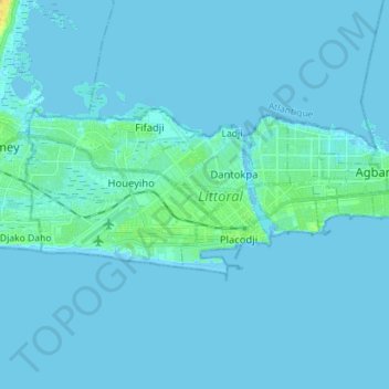
Name: Littoral topographic map, elevation, terrain.

Location: Littoral, Benin (6.33728 2.35457 6.39924 2.49584)

Average elevation: 2 m

Minimum elevation: -4 m

Maximum elevation: 20 m

Littoral Department borders Ouémé Department and Atlantique Department and is situated in a coastal area that has interconnected lakes and lagoons and elongated coastlines with wide marshes. Freshwater and seawater fishing is the major profession in the region. Petroleum was discovered in the 1960s in offshore areas, while titanium, low-quality iron ore, ilmenite and chromite are the major minerals. The southern regions of Benin receive two spells from March to July and September to November while the northern regions of the country receive one season of rainfall from May to September. The country receives an average annual rainfall of around 1,200 mm (47 in), but Littoral Department receives less rainfall. The department's region has mostly low-lying sandy coastal plains towards the Atlantic Ocean, marshes, lagoons and lakes. The highest elevation in the department around the coastal plains is 20 m (66 ft) compared to the average 200 m (660 ft) above average mean sea level of the country.

Wikipedia (CC-BY-SA 3.0)

Other topographic maps

Click on a map to view its topography, its elevation and its terrain.

Djègbadji

Benin > Atlantique Department > Ouidah

Djègbadji, Ouidah, Atlantique Department, Benin

Average elevation: 2 m

Zou Department

Benin

Zou Department, Benin

Average elevation: 108 m

Godomey

Benin > Atlantique Department > Abomey-Calavi

Godomey, Abomey-Calavi, Atlantique Department, Benin

Average elevation: 5 m

Sandilo

Benin > Borgou Department > Pèrèrè

Sandilo, Pèrèrè, Borgou Department, Benin

Average elevation: 433 m

Bohicon

Benin > Zou Department

Bohicon, Zou Department, Benin

Average elevation: 164 m

Tanguieta

Benin > Atakora Department > Tanguièta

Tanguieta, Tanguièta, Atakora Department, Benin

Average elevation: 293 m

Nassy

Benin > Borgou Department > Pèrèrè > Nassy

Nassy, Pèrèrè, Borgou Department, Benin

Average elevation: 386 m

Ouara

Benin > Alibori Department > Gogounou

Ouara, Gogounou, Alibori Department, Benin

Average elevation: 336 m

Abomey-Calavi

Benin > Atlantique Department

Abomey-Calavi, Atlantique Department, Benin

Average elevation: 23 m

Cotonou

Benin > Littoral

Cotonou, Littoral, Benin

Average elevation: 2 m

Nikki

Benin > Borgou > Nikki

Nikki, Borgou, Benin

Average elevation: 375 m

Okéo

Benin > Collines > Okéo

Okéo, Glazoué, Collines, Benin

Average elevation: 173 m

Porto-Novo

Benin > Ouémé Department > Porto Novo

Porto-Novo, Porto Novo, Ouémé Department, Benin

Average elevation: 15 m

Dramè

Benin > Zou > Kpakpamè > Dramè

Dramè, Kpakpamè, Za-Kpota, Zou, Benin

Average elevation: 182 m

Kinta

Benin > Zou > Kinta

Kinta, Agbangnizoun, Zou, Benin

Average elevation: 122 m

Sabi

Benin > Borgou

Sabi, N'Dali, Borgou, Benin

Average elevation: 328 m

Kalalé

Benin > Borgou

Kalalé, Borgou, Benin

Average elevation: 323 m

Koli

Benin > Atakora

Koli, Kerou, Atakora, Benin

Average elevation: 316 m

Mont Sokbaro

Benin > Donga > Bassila

Mont Sokbaro, Bassila, Donga, Benin

Average elevation: 514 m

Tanguièta

Benin > Atakora > Tanguièta

Tanguièta, Atakora, Benin

Average elevation: 269 m

Boutou

Benin > Donga > Boutou

Boutou, Bassila, Donga, Benin

Average elevation: 423 m

Yarra

Benin > Borgou > Sinendé > Yarra

Yarra, Sinendé, Borgou, Benin

Average elevation: 346 m

Kinta

Benin > Zou > Kinta

Kinta, Agbangnizoun, Zou, Benin

Average elevation: 128 m