
North Island topographic map
Interactive map
Click on the map to display elevation.
About this map
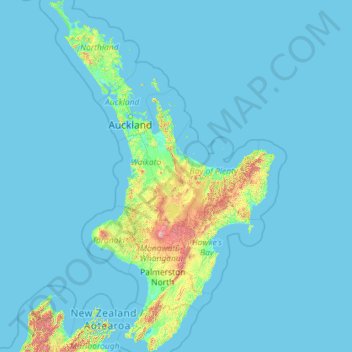
Name: North Island topographic map, elevation, terrain.
Location: North Island, New Zealand (-41.61375 172.64302 -34.39339 178.55051)
Average elevation: 66 m
Minimum elevation: -1 m
Maximum elevation: 2,650 m
Other topographic maps
Click on a map to view its topography, its elevation and its terrain.
Pearl Harbour
New Zealand > Southland > Southland District > Fiordland Community > Manapouri
Pearl Harbour, Manapouri, Fiordland Community, Southland District, Southland, 7969, New Zealand
Average elevation: 212 m
Rangitīkei District
New Zealand > Manawatu-Whanganui
Rangitīkei District, Manawatū-Whanganui, New Zealand
Average elevation: 538 m
Queenstown
New Zealand > Otago > Queenstown-Lakes District
Queenstown, Queenstown-Lakes District, Otago, 9348, New Zealand
Average elevation: 592 m
Hydra Island
New Zealand > Canterbury > Selwyn District
Hydra Island, Selwyn District, Canterbury, New Zealand
Average elevation: 474 m
Ngongotahā
New Zealand > Bay of Plenty > Rotorua Lakes District
Ngongotahā, Rotorua Lakes District, Bay of Plenty, New Zealand
Average elevation: 339 m
Murphy Park
New Zealand > Canterbury > Waimakariri District > Kaiapoi
Murphy Park, Kaiapoi, Waimakariri District, Canterbury, New Zealand
Average elevation: 3 m
Tangiteroria
New Zealand > Northland > Kaipara District
Tangiteroria, Kaipara District, Northland, 0381, New Zealand
Average elevation: 33 m
Otuhi
New Zealand > Northland > Whangarei District
Otuhi, Whangārei District, Northland, New Zealand
Average elevation: 118 m
Lake Rotorua
New Zealand > Bay of Plenty > Rotorua Lakes District > Hamurana
Lake Rotorua, Hamurana, Rotorua Lakes District, Bay of Plenty, 3040, New Zealand
Average elevation: 299 m
Pōkeno
New Zealand > Waikato > Waikato District
Pōkeno, Waikato District, Waikato, 2472, New Zealand
Average elevation: 66 m
Lake Ōnoke
New Zealand > Wellington > South Wairarapa District > Featherston Community
Lake Ōnoke, Featherston Community, South Wairarapa District, Wellington, New Zealand
Average elevation: 2 m
Mount Head
New Zealand > Otago > Queenstown-Lakes District
Mount Head, Queenstown-Lakes District, Otago, New Zealand
Average elevation: 1,992 m
Leithfield
New Zealand > Canterbury > Hurunui District
Leithfield, Hurunui District, Canterbury, 7481, New Zealand
Average elevation: 19 m
Tableland
New Zealand > Tasman > Tasman District
Tableland, Tasman District, Tasman, New Zealand
Average elevation: 779 m
Taumatawhakatangihangakōauauotamateapōkaiwhenuakitānatahu
New Zealand > Hawke's Bay > Central Hawke's Bay District
Taumatawhakatangihangakōauauotamateapōkaiwhenuakitānatahu, Central Hawke's Bay District, Hawke's Bay, New Zealand
Average elevation: 199 m
Blumine Island / Ōruawairua
Blumine Island / Ōruawairua, Marlborough, New Zealand
Average elevation: 37 m
Tuatapere Te Waewae Community
New Zealand > Southland > Southland District
Tuatapere Te Waewae Community, Southland District, Southland, 9620, New Zealand
Average elevation: 324 m
Greenhills
New Zealand > Southland > Invercargill City
Greenhills, Invercargill City, Southland, New Zealand
Average elevation: 10 m
Arowhenua
New Zealand > Canterbury > Timaru District > Temuka
Arowhenua, Temuka, Timaru District, Canterbury, 7985, New Zealand
Average elevation: 21 m
Kakanui
New Zealand > Otago > Waitaki District
Kakanui, Waitaki District, Otago, 9495, New Zealand
Average elevation: 10 m
Lake Okareka
New Zealand > Bay of Plenty > Rotorua Lakes District
Lake Okareka, Rotorua Lakes District, Bay of Plenty, New Zealand
Average elevation: 441 m
Waikanae
New Zealand > Wellington > Kapiti Coast District
Waikanae, Kāpiti Coast District, Wellington, 5036, New Zealand
Average elevation: 112 m
Tokaanu
New Zealand > Waikato > Taupo District
Tokaanu, Taupō District, Waikato, New Zealand
Average elevation: 409 m
The Peak
New Zealand > Taranaki > New Plymouth District
The Peak, New Plymouth District, Taranaki, New Zealand
Average elevation: 305 m
Rangitaiki River
New Zealand > Bay of Plenty > Taupō District
Rangitaiki River, Taupō District, Bay of Plenty, New Zealand
Average elevation: 690 m
Lake Tekapo
New Zealand > Canterbury > Mackenzie District
Lake Tekapo, Mackenzie District, Canterbury, New Zealand
Average elevation: 1,025 m
Akaroa
New Zealand > Canterbury > Christchurch City > Banks Peninsula Community
Akaroa, Banks Peninsula Community, Christchurch City, Canterbury, New Zealand
Average elevation: 191 m
Te Araroa
New Zealand > Gisborne > Gisborne District
Te Araroa, Gisborne District, Gisborne, 4087, New Zealand
Average elevation: 40 m
Hogs Back
New Zealand > Canterbury > Selwyn District
Hogs Back, Selwyn District, Canterbury, 7580, New Zealand
Average elevation: 925 m
Dicks Hill
New Zealand > Otago > Dunedin City
Dicks Hill, Dunedin City, Otago, 9014, New Zealand
Average elevation: 128 m
Māhia Peninsula
New Zealand > Hawke's Bay > Wairoa District
Māhia Peninsula, Wairoa District, Hawke's Bay, 4198, New Zealand
Average elevation: 41 m
Kawerau District
Kawerau District, Bay of Plenty, New Zealand
Average elevation: 107 m
Silent Valley
New Zealand > Auckland > Franklin
Silent Valley, Franklin, Auckland, 2343, New Zealand
Average elevation: 211 m
Raglan
New Zealand > Waikato > Waikato District
Raglan, Waikato District, Waikato, 3225, New Zealand
Average elevation: 41 m
Whitehall
New Zealand > Waikato > Waipa District
Whitehall, Waipa District, Waikato, New Zealand
Average elevation: 157 m
Greymouth
New Zealand > West Coast > Grey District
Greymouth, Grey District, West Coast, 7801, New Zealand
Average elevation: 40 m