
Epsom and Ewell topographic map
Interactive map
Click on the map to display elevation.
Epsom and Ewell
The borough is at a range of elevations, scaling the lower slopes of the North Downs and drains into a large stream which springs above the surface in Ewell, the Hogsmill River which drains into the Thames at Kingston. The borough comprises.
About this map
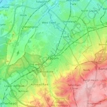
Name: Epsom and Ewell topographic map, elevation, terrain.
Location: Epsom and Ewell, Surrey, England, United Kingdom (51.29233 -0.30621 51.38022 -0.21729)
Average elevation: 73 m
Minimum elevation: 12 m
Maximum elevation: 181 m
Surrey trails, hiking, mountain biking, running and outdoor activities
Other topographic maps
Click on a map to view its topography, its elevation and its terrain.
Reigate
United Kingdom > England > Surrey > Reigate and Banstead
Reigate is in central Surrey, around 19 mi (30 km) south of central London and 9 mi (14 km) north of Gatwick Airport. The town is in the Vale of Holmesdale, below the North Downs escarpment. The average elevation in the centre is 80 m (260 ft) above ordnance datum (OD) and the area is drained by the Wallace…
Average elevation: 100 m
Gunpowder Mills Fishery
United Kingdom > England > Surrey > Guildford > Chilworth
Average elevation: 84 m
Camberley
United Kingdom > England > Surrey > Surrey Heath
The Staff College, to the north of Camberley town centre, is part of the Joint Services Command and Staff College, which provides training and education for established officers in the British Armed Forces and civil servants in the Ministry of Defence. The institution has its origins in the Royal Military…
Average elevation: 88 m
Caterham
United Kingdom > England > Surrey > Tandridge
In 1840 Caterham contained a total of 477 residents (figures taken from that census, compiled in an 1848 topographical encyclopedia) and in 1848 468 acres (189 ha) of its 2,386 acres (966 ha) were common land. Similar to today, 175 acres (71 ha) mostly steeper acres were woodland.
Average elevation: 157 m
Redhill
United Kingdom > England > Surrey > Reigate and Banstead
To the north, the town joins with the village of Merstham, north of which there is a "wind gap" in the chalk hills of the North Downs, at an elevation of 120 metres (390 ft) above sea level, through which the A23 road heads in from London. Geologists have speculated that there may once have been a…
Average elevation: 107 m
Camberley
United Kingdom > England > Surrey > Surrey Heath
The Staff College, to the north of Camberley town centre, is part of the Joint Services Command and Staff College, which provides training and education for established officers in the British Armed Forces and civil servants in the Ministry of Defence. The institution has its origins in the Royal Military…
Average elevation: 88 m
Reigate
United Kingdom > England > Surrey > Reigate and Banstead
Reigate is in central Surrey, around 19 mi (30 km) south of central London and 9 mi (14 km) north of Gatwick Airport. The town is in the Vale of Holmesdale, below the North Downs escarpment. The average elevation in the centre is 80 m (260 ft) above ordnance datum (OD) and the area is drained by the Wallace…
Average elevation: 100 m
Tillingbourne Trout Farm and Smokery
United Kingdom > England > Surrey > Guildford > Shere
Average elevation: 123 m
Caterham
United Kingdom > England > Surrey > Tandridge
In 1840 Caterham contained a total of 477 residents (figures taken from that census, compiled in an 1848 topographical encyclopedia) and in 1848 468 acres (189 ha) of its 2,386 acres (966 ha) were common land. Similar to today, 175 acres (71 ha) mostly steeper acres were woodland.
Average elevation: 157 m
Margery
United Kingdom > England > Surrey > Reigate and Banstead > Lower Kingswood
Average elevation: 155 m
Kalima Caravan Site
United Kingdom > England > Surrey > Surrey Heath > Chobham
Average elevation: 28 m
Buckland Corner
United Kingdom > England > Surrey > Reigate and Banstead > Reigate
Average elevation: 82 m
West Byfleet
United Kingdom > England > Surrey > Woking
The surface undulates gently from the west to the east, where West Byfleet's land is drained in the parish of Byfleet itself by the River Wey. Soil ranges from sandy acidic soil in the west to more alluvial soil in the east, underlain by a mixture of gravel and clay. Elevations range from 18m Above Ordnance…
Average elevation: 26 m
Lyn Mushroom Farm
United Kingdom > England > Surrey > Borough of Runnymede > Lyne
Average elevation: 39 m
Queen Mary Reservoir
United Kingdom > England > Surrey > Borough of Spelthorne > Charlton
Average elevation: 14 m
Gatton
United Kingdom > England > Surrey > Reigate and Banstead
Gatton's elevations range from 215m AOD, the highest elevation, along Fort Lane, a cul-de-sac off the intersection of Reigate Hill (M25 Junction 8) which leads to four homes over the boundary in Reigate, a radio transmitter station, and a water tower. On the A217 is the Bridge House Hotel, whose name refers to…
Average elevation: 134 m
Nork Park
United Kingdom > England > Surrey > Reigate and Banstead > Banstead
Average elevation: 143 m
Abinger Roughs
United Kingdom > England > Surrey > Mole Valley > Abinger Hammer
Average elevation: 141 m
Redhill Common
United Kingdom > England > Surrey > Reigate and Banstead > Redhill
Average elevation: 92 m
Cooper's Hill Slopes
United Kingdom > England > Surrey > Borough of Runnymede > Englefield Green
Average elevation: 38 m
Hankley Common
United Kingdom > England > Surrey > Waverley > Thursley > Truxford
Average elevation: 70 m
Upper Halliford
United Kingdom > England > Surrey > Borough of Spelthorne
Based on 1841 census statistics, Samuel Lewis (publisher) in his 1848 A topographical guide to England stated the population of the parish of Sunbury which included Charlton and Upper Halliford, an area of 2,580 acres (1,040 ha) was 1,828.
Average elevation: 13 m