Richmond topographic map
Click on the map to display elevation.
Richmond
Richmond occupies a distinctive topographic threshold in central Virginia, where the rolling uplands of the Piedmont meet the lower, gentler Atlantic Coastal Plain along the James River fall zone. The city’s terrain is shaped by this transition: west and southwest of the urban core, the land rises into dissected, undulating hills and stream-cut ridges, while eastward it gradually opens into broader, flatter lowlands associated with the Coastal Plain. The James River forms the dominant relief feature, carving a pronounced corridor through the city and dropping across ledges, rapids, islands, and rocky channels near downtown before becoming lower and more navigable downstream. Local elevation patterns are therefore varied but moderate, with higher ground on the surrounding uplands and lower floodplain surfaces along the James and its tributaries, giving Richmond a landscape of terraces, ravines, wooded creek valleys, and urban hills rather than broad mountains or uniform plains. This mix of rocky fall-line river scenery, rolling Piedmont edges, and softer eastern lowlands gives Richmond a compact but notably expressive physical character.
About this map
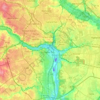
Name: Richmond topographic map, elevation, terrain.
Location: Richmond, Virginia, United States (37.44673 -77.60117 37.60281 -77.38551)
Average elevation: 49 m
Minimum elevation: -46 m
Maximum elevation: 105 m
Other topographic maps
Click on a map to view its topography, its elevation and its terrain.
Virginia Beach
United States > Virginia > Virginia Beach
According to the United States Census Bureau, the city has a total area of 497 square miles (1,290 km2), of which 249 square miles (640 km2) is land and 248 square miles (640 km2) (49.9%) is water. It is the largest city in Virginia by total area and third-largest city land area. The average elevation is 12…
Average elevation: 2 m
Prince William Forest Park
United States > Virginia > Prince William County > Triangle
Average elevation: 81 m





Hawksbill
United States > Virginia > Madison County
Hawksbill Mountain is a mountain with an elevation of 4,050 feet (1,234 m). Marking the border between Madison County and Page County in Virginia, the summit of Hawksbill Mountain is the highest point in Shenandoah National Park as well as the highest point in both Madison and Page Counties.
Average elevation: 993 m



Blue Ridge Mountains
United States > Virginia > Botetourt County
Although the term "Blue Ridge" is sometimes applied exclusively to the eastern edge or front range of the Appalachian Mountains, the geological definition of the Blue Ridge province extends westward to the Ridge and Valley area, encompassing the Great Smoky Mountains, the Great Balsams, the Roans, the Blacks,…
Average elevation: 460 m
















Eggleston
United States > Virginia > Giles County
It lies at an elevation of 1,821 feet.
Average elevation: 572 m