
Orleans County topographic map
Interactive map
Click on the map to display elevation.
About this map
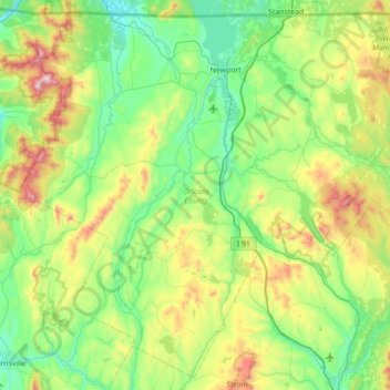
Name: Orleans County topographic map, elevation, terrain.
Location: Orleans County, Vermont, United States (44.54249 -72.57907 45.00883 -71.87786)
Average elevation: 409 m
Minimum elevation: 150 m
Maximum elevation: 1,148 m
Other topographic maps
Click on a map to view its topography, its elevation and its terrain.
Camels Hump
United States > Vermont > Chittenden County > Huntington
The summit of Camel's Hump is home to 10 acres (4 ha) of alpine tundra vegetation. Common plants found in this area include: Bigelow's sedge (Carex bigelowii), alpine bilberry (Vaccinium uliginosum), mountain sandwort (Minuartia groenlandica), crowberry (Empetrum nigrum), mountain cranberry (Vaccinium…
Average elevation: 843 m
Billings Mobile Manor
United States > Vermont > Rutland County > Rutland City
Average elevation: 211 m
Heineberg Bridge Fishing Wilderness Access
United States > Vermont > Chittenden County
Average elevation: 39 m
Mount Mansfield
United States > Vermont > Chittenden County > Underhill
Mount Mansfield is the highest mountain in Vermont, reaching an elevation of 4,393 feet (1,339 m) above sea level. Located in the northwest of the state, it is also the highest peak in the Green Mountains. Its summit is located within the town of Underhill in Chittenden County; the ridgeline, including some…
Average elevation: 914 m
Lake Dunmore
United States > Vermont > Addison County > Salisbury > Lake Dunmore
Average elevation: 192 m
Bellows Falls
United States > Vermont > Windham County > Rockingham > Bellows Falls
Average elevation: 161 m
Wilmington
United States > Vermont > Windham County > Wilmington > Wilmington
Wilmington experiences a humid continental climate (Koppen Dfb) with warm, humid summers and cold (sometimes severely cold) winters. While snowfall can vary greatly from year to year in nearby towns like Bennington and Brattleboro, Wilmington's snowfall is consistently heavy each year because of its elevation…
Average elevation: 515 m
Camels Hump
United States > Vermont > Chittenden County > Huntington
The summit of Camel's Hump is home to 10 acres (4 ha) of alpine tundra vegetation. Common plants found in this area include: Bigelow's sedge (Carex bigelowii), alpine bilberry (Vaccinium uliginosum), mountain sandwort (Minuartia groenlandica), crowberry (Empetrum nigrum), mountain cranberry (Vaccinium…
Average elevation: 843 m