
Make a donation
Gear up for your next adventure:
As an Amazon Associate, this site earns from qualifying purchases at no extra cost to you.
Tideswell CP topographic map
Click on the map to display elevation.
Make a donation
Gear up for your next adventure:
As an Amazon Associate, this site earns from qualifying purchases at no extra cost to you.
Tideswell CP
Tideswell is a village and civil parish in the Peak District of Derbyshire, England. It lies 6 miles (9.7 km) east of Buxton on the B6049, in a wide valley on a limestone plateau, at an altitude of 1,000 feet (300 m) above sea level, and is within the District of Derbyshire Dales. The population (including Wheston) was 1,820 in 2001, increasing slightly to 1,827 at the 2011 Census, making it the second-largest settlement within the National Park, after Bakewell. Tideswell Dale is a short limestone valley leading south from the village to the River Wye valley.
Make a donation
Gear up for your next adventure:
As an Amazon Associate, this site earns from qualifying purchases at no extra cost to you.
About this map
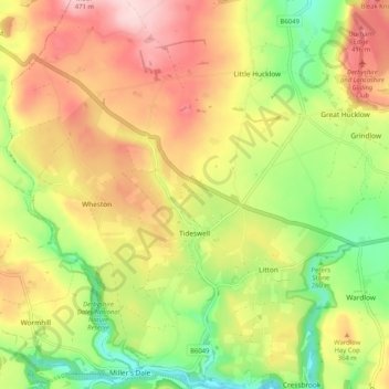
Name: Tideswell CP topographic map, elevation, terrain.
Average elevation: 321 m
Minimum elevation: 193 m
Maximum elevation: 453 m
Derbyshire trails, hiking, mountain biking, running and outdoor activities
Make a donation
Gear up for your next adventure:
As an Amazon Associate, this site earns from qualifying purchases at no extra cost to you.
Other topographic maps
Click on a map to view its topography, its elevation and its terrain.
Hallam Moors
United Kingdom > England > Derbyshire > Derbyshire Dales > Hathersage
Average elevation: 368 m
Slaley
United Kingdom > England > Derbyshire > Derbyshire Dales > Matlock > Bonsall CP
Average elevation: 263 m
Make a donation
Gear up for your next adventure:
As an Amazon Associate, this site earns from qualifying purchases at no extra cost to you.
Bolehill
United Kingdom > England > Derbyshire > Derbyshire Dales > Wirksworth CP
Average elevation: 220 m
Make a donation
Gear up for your next adventure:
As an Amazon Associate, this site earns from qualifying purchases at no extra cost to you.
Two Dales
United Kingdom > England > Derbyshire > Derbyshire Dales > Darley Dale CP > Darley Hillside
Average elevation: 189 m
Starkholmes
United Kingdom > England > Derbyshire > Derbyshire Dales > Matlock
Average elevation: 175 m
Make a donation
Gear up for your next adventure:
As an Amazon Associate, this site earns from qualifying purchases at no extra cost to you.
Farley Wood
United Kingdom > England > Derbyshire > Derbyshire Dales > Matlock
Average elevation: 255 m
Magpie Mine
United Kingdom > England > Derbyshire > Derbyshire Dales > Ashford in the Water CP
Average elevation: 303 m
Make a donation
Gear up for your next adventure:
As an Amazon Associate, this site earns from qualifying purchases at no extra cost to you.
Catcliff Wood
United Kingdom > England > Derbyshire > Derbyshire Dales > Bakewell CP
Average elevation: 173 m
Gang Mine
United Kingdom > England > Derbyshire > Derbyshire Dales > Cromford CP
Average elevation: 226 m
Make a donation
Gear up for your next adventure:
As an Amazon Associate, this site earns from qualifying purchases at no extra cost to you.
Taddington Dale
United Kingdom > England > Derbyshire > Derbyshire Dales > Brushfield CP
Average elevation: 281 m
Cressbrook Dale
United Kingdom > England > Derbyshire > Derbyshire Dales > Litton CP > Litton Mill
Average elevation: 286 m
Curbar Edge
United Kingdom > England > Derbyshire > Derbyshire Dales > Curbar CP
Average elevation: 252 m
Make a donation
Gear up for your next adventure:
As an Amazon Associate, this site earns from qualifying purchases at no extra cost to you.
Hathersage Booths
United Kingdom > England > Derbyshire > Derbyshire Dales > Hathersage
Average elevation: 260 m
Make a donation
Gear up for your next adventure:
As an Amazon Associate, this site earns from qualifying purchases at no extra cost to you.
Stanage Plantation
United Kingdom > England > Derbyshire > Derbyshire Dales > Hathersage
Average elevation: 360 m
Make a donation
Gear up for your next adventure:
As an Amazon Associate, this site earns from qualifying purchases at no extra cost to you.
Black Rocks
United Kingdom > England > Derbyshire > Derbyshire Dales > Cromford CP
Average elevation: 199 m
Make a donation
Gear up for your next adventure:
As an Amazon Associate, this site earns from qualifying purchases at no extra cost to you.
Curbar Edge
United Kingdom > England > Derbyshire > Derbyshire Dales > Calver Sough
Average elevation: 251 m
Riber Castle
United Kingdom > England > Derbyshire > Derbyshire Dales > Matlock > Starkholmes
Average elevation: 169 m
Monsal Head
United Kingdom > England > Derbyshire > Derbyshire Dales > Cressbrook > Monsal Head
Average elevation: 231 m
Padley Gorge
United Kingdom > England > Derbyshire > Derbyshire Dales > Grindleford
Average elevation: 316 m
Make a donation
Gear up for your next adventure:
As an Amazon Associate, this site earns from qualifying purchases at no extra cost to you.
Breamfield
United Kingdom > England > Derbyshire > Derbyshire Dales > Wirksworth CP > Breamfield
Average elevation: 213 m
Make a donation
Gear up for your next adventure:
As an Amazon Associate, this site earns from qualifying purchases at no extra cost to you.
Coplow Dale
United Kingdom > England > Derbyshire > Derbyshire Dales > Little Hucklow
Average elevation: 333 m
Stoke Brook
United Kingdom > England > Derbyshire > Derbyshire Dales > Calver Sough
Average elevation: 197 m
Yarncliff Wood
United Kingdom > England > Derbyshire > Derbyshire Dales > Grindleford
Average elevation: 260 m
Make a donation
Gear up for your next adventure:
As an Amazon Associate, this site earns from qualifying purchases at no extra cost to you.
Calver Sough
United Kingdom > England > Derbyshire > Derbyshire Dales > Calver Sough
Average elevation: 218 m
Parsley Hay
United Kingdom > England > Derbyshire > Derbyshire Dales > Parsley Hay
Average elevation: 334 m
Longstone Edge
United Kingdom > England > Derbyshire > Derbyshire Dales > Rowland
Average elevation: 290 m
Make a donation
Gear up for your next adventure:
As an Amazon Associate, this site earns from qualifying purchases at no extra cost to you.
Arbor Low
United Kingdom > England > Derbyshire > Derbyshire Dales > Parsley Hay
Average elevation: 342 m
Longcliffe
United Kingdom > England > Derbyshire > Derbyshire Dales > Brassington CP
Average elevation: 299 m
Lathkill Dale
United Kingdom > England > Derbyshire > Derbyshire Dales > Youlgreave
Average elevation: 269 m
Make a donation
Gear up for your next adventure:
As an Amazon Associate, this site earns from qualifying purchases at no extra cost to you.
Breamfield
United Kingdom > England > Derbyshire > Derbyshire Dales > Wirksworth CP
Average elevation: 213 m
Wirksworth Moor
United Kingdom > England > Derbyshire > Derbyshire Dales > Wirksworth CP
Average elevation: 207 m
Make a donation
Gear up for your next adventure:
As an Amazon Associate, this site earns from qualifying purchases at no extra cost to you.
Padley Gorge
United Kingdom > England > Derbyshire > Derbyshire Dales > Grindleford
Average elevation: 316 m
Make a donation
Gear up for your next adventure:
As an Amazon Associate, this site earns from qualifying purchases at no extra cost to you.