
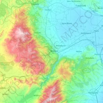
Imathia Regional Unit topographic map
Interactive map
Click on the map to display elevation.
About this map
Name: Imathia Regional Unit topographic map, elevation, terrain.
Average elevation: 490 m
Minimum elevation: -1 m
Maximum elevation: 2,169 m
Other topographic maps
Click on a map to view its topography, its elevation and its terrain.
Sithonia
Greece > Macedonia and Thrace > Chalkidiki Regional Unit > Toroni Municipal Unit
Average elevation: 473 m
Irakleia
Greece > Macedonia and Thrace > Serres Regional Unit > Iraklia Municipal Unit
Average elevation: 33 m
Toroni
Greece > Macedonia and Thrace > Chalkidiki Regional Unit > Toroni Municipal Unit
Average elevation: 48 m
Παλαιό Κεραμίδι
Greece > Macedonia and Thrace > Pieria Regional Unit > Katerini Municipality
Average elevation: 114 m
Νεόκτιστα
Greece > Macedonia and Thrace > Thessaloniki Regional Unit > Stavroupoli Municipal Unit
Average elevation: 69 m
Olympiaki Akti (Beach)
Greece > Macedonia and Thrace > Pieria Regional Unit > Katerini Municipality
Average elevation: 2 m
Paralia
Greece > Macedonia and Thrace > Pieria Regional Unit > Katerini Municipality
Average elevation: 5 m
Άγιος Δημήτριος
Greece > Macedonia and Thrace > Pieria Regional Unit > Katerini Municipality
Average elevation: 1,010 m
Neos Marmaras
Greece > Macedonia and Thrace > Chalkidiki Regional Unit > Sithonia Municipal Unit
Average elevation: 89 m
Komotini
Greece > Macedonia and Thrace > Rodopi Regional Unit
The city stands at an altitude of 32-38m on the Thracian plain near the foothills of the Rhodope Mountains. It is situated between two rivers, Boklutzas on the west and Trelohimaros on the east (which form, alongside the Karidia stream, the river Bosbozis). There is little urban planning in the older parts of…
Average elevation: 231 m
Paliouri
Greece > Macedonia and Thrace > Evros Regional Unit > Metaxades Municipal Unit
Average elevation: 132 m
Αγία Σοφία
Greece > Macedonia and Thrace > Thessaloniki Regional Unit > Municipal Unit of Echedoros
Average elevation: 9 m
Πέλεκας
Greece > Macedonia and Thrace > Pieria Regional Unit > Katerini Municipality > Αρωνάς
Average elevation: 140 m
Τόξο
Greece > Macedonia and Thrace > Pieria Regional Unit > Katerini Municipality
Average elevation: 236 m
Σίνδος
Greece > Macedonia and Thrace > Thessaloniki Regional Unit > Municipal Unit of Echedoros
Average elevation: 7 m
Αγγελοχώρι
Greece > Macedonia and Thrace > Thessaloniki Regional Unit
Angelochori (Greek: Αγγελοχώρι) is a village in the municipal unit of Thermaikos, in the Thessaloniki regional unit, Greece. It is located to the east of Cape Megalo Embolo (Μεγάλο έμβολο), at an average elevation of 16 meters above the sea level.
Average elevation: 16 m
Λιβάδι
Greece > Macedonia and Thrace > Thessaloniki Regional Unit
Livadi (Greek: Λιβάδι) is a village in Vasilika, Thermi, Thessaloniki, Greece. It is located at an average elevation of 716 meters above the sea level.
Average elevation: 716 m
Καστανιά
Greece > Macedonia and Thrace > Imathia Regional Unit > Veria Municipality
Average elevation: 1,434 m
Πεύκα
Greece > Macedonia and Thrace > Thessaloniki Regional Unit > Pefka Municipal Unit
Average elevation: 262 m
Ράχη
Greece > Macedonia and Thrace > Pieria Regional Unit > Katerini Municipality
Average elevation: 202 m
Sarti
Greece > Macedonia and Thrace > Chalkidiki Regional Unit > Toroni Municipal Unit
Average elevation: 41 m
Οικισμός "Φοίνικες"
Greece > Macedonia and Thrace > Chalkidiki Regional Unit > Οικισμός "Φοίνικες"
Average elevation: 8 m
Mani
Greece > Macedonia and Thrace > Evros Regional Unit > Didymoteicho Municipal Unit
Mani (Greek: Μάνη) is a village and a community in the municipality of Didymoteicho in the Evros regional unit, Greece. It is situated near the left bank of the river Erythropotamos, 2 km west of Karoti, 4 km northeast of Kyani and 10 km northwest of Didymoteicho town centre. In 2021 its population was 364…
Average elevation: 53 m
Μάτι
The Pangaion Hills (Greek Παγγαίο Pangéo; ancient Greek: Καρμάνιον Karmánion, Παγγαῖος Pangaîos, m., Παγγαῖον Pangaîon oder Πάγγαιον Pángaion , n.; Homeric name: Nysa; also called Pangaeon, Pangaeum) are a mountain range in Greece, approximately 40 km from Kavala.…
Average elevation: 1,678 m
Vergina
Greece > Macedonia and Thrace > Imathia Regional Unit > Veria Municipality
Average elevation: 141 m
Agia Foteini
Greece > Macedonia and Thrace > Pella Regional Unit > Agia Foteini
Average elevation: 700 m
Agios Athanasios
Greece > Macedonia and Thrace > Thessaloniki Regional Unit > Agios Athanasios
Average elevation: 26 m