
Sikkim topographic map
Interactive map
Click on the map to display elevation.
About this map
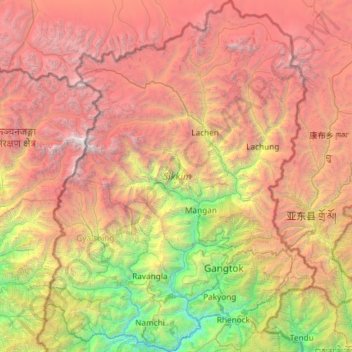
Name: Sikkim topographic map, elevation, terrain.
Location: Sikkim, India (27.07940 88.01203 28.12264 88.92137)
Average elevation: 3,786 m
Minimum elevation: 264 m
Maximum elevation: 8,447 m
Situated in the Himalayan mountains, the state of Sikkim is characterised by mountainous terrain. Almost the entire state is hilly, with an elevation ranging from 280 metres (920 ft) in the south at the border with West Bengal to 8,586 metres (28,169 ft) in northern peaks near Nepal and Tibet. The summit of Kangchenjunga, the world's third-highest peak, is the state's highest point, situated on the border between Sikkim and Nepal. For the most part, the land is unfit for agriculture because of the rocky, precipitous slopes. However, some hill slopes have been converted into terrace farms.
Other topographic maps
Click on a map to view its topography, its elevation and its terrain.
Chennai
India > Tamil Nadu > Chennai
Chennai, Chennai District, Tamil Nadu, India
Average elevation: 8 m
Bengaluru
India > Karnataka > Bangalore North
Bengaluru, Bangalore North, Bengaluru Urban District, Karnataka, India
Average elevation: 881 m
3d
India > Rajasthan > Ganganagar Tehsil > 1 LNP
3d, 1 LNP, Ganganagar Tehsil, Sri Ganganagar District, Rajasthan, India
Average elevation: 178 m
Whitefield
India > Karnataka > Bangalore East > Bengaluru
Whitefield, Bengaluru, Bangalore East, Bengaluru Urban District, Karnataka, 560066, India
Average elevation: 875 m
Pune
India > Maharashtra > Pune City > Pune
Pune, Pune City, Pune District, Maharashtra, 411001, India
Average elevation: 641 m
Kolkata
Kolkata, Kolkata District, West Bengal, 700073, India
Average elevation: 5 m
Mysuru
India > Karnataka > Mysuru taluk
Mysuru, Mysuru taluk, Mysuru District, Karnataka, 570001, India
Average elevation: 727 m
Coimbatore
India > Tamil Nadu > Coimbatore North
Coimbatore, Coimbatore North, Coimbatore District, Tamil Nadu, 641001, India
Average elevation: 452 m
Gurgaon
India > Haryana > Gurugram District
Gurgaon, Gurugram District, Haryana, India
Average elevation: 237 m
Kodaikanal
Kodaikanal, Dindigul District, Tamil Nadu, India
Average elevation: 869 m
Lucknow
India > Uttar Pradesh > Lucknow
Lucknow, Lucknow District, Uttar Pradesh, 226027, India
Average elevation: 120 m
Karaikudi
India > Tamil Nadu > Karaikkudi
Karaikudi, Karaikkudi, Sivagangai District, Tamil Nadu, 623001, India
Average elevation: 87 m
Pimpri-Chinchwad
India > Maharashtra > Haveli
Pimpri-Chinchwad, Haveli, Pune District, Maharashtra, 411089, India
Average elevation: 605 m
Western Ghats
Western Ghats, Idukki, Kerala, 685614, India
Average elevation: 2,225 m
Chhota Bhanuja
India > Rajasthan > Khamnor Tehsil
Chhota Bhanuja, Khamnor Tehsil, Rajsamand District, Rajasthan, 313321, India
Average elevation: 644 m
Chikodi taluk
Chikodi taluk, Belagavi District, Karnataka, India
Average elevation: 613 m
Narhe
India > Maharashtra > Bhor
Narhe, Bhor, Pune District, Maharashtra, India
Average elevation: 683 m
Nathdwara
India > Rajasthan > Nathdwara Tehsil
Nathdwara, Nathdwara Tehsil, Rajsamand District, Rajasthan, 313301, India
Average elevation: 590 m
Kukshi
India > Madhya Pradesh > Kukshi Tahsil > Kukshi
Kukshi, Kukshi Tahsil, Dhar District, Madhya Pradesh, 454331, India
Average elevation: 176 m
Thoothukudi
India > Tamil Nadu > Thoothukkudi
Thoothukudi, Thoothukkudi, Thoothukudi District, Tamil Nadu, 628001, India
Average elevation: 10 m
North Sentinel Island
India > Andaman and Nicobar Islands > Ferrargunj
North Sentinel Island, Ferrargunj, South Andaman District, Andaman and Nicobar Islands, India
Average elevation: 20 m
Bachupally mandal
Bachupally mandal, Medchal–Malkajgiri District, Telangana, 500090, India
Average elevation: 593 m
Tehri-Garhwal
Tehri-Garhwal, Tehri Garhwal District, Uttarakhand, 249125, India
Average elevation: 2,339 m