
Chilton topographic map
Click on the map to display elevation.
About this map
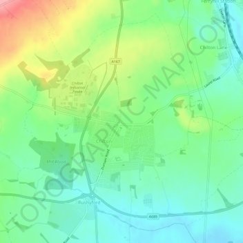
Name: Chilton topographic map, elevation, terrain.
Location: Chilton, County Durham, North East, England, United Kingdom (54.64949 -1.57888 54.67949 -1.52099)
Average elevation: 112 m
Minimum elevation: 74 m
Maximum elevation: 186 m
County Durham trails, hiking, mountain biking, running and outdoor activities
Other topographic maps
Click on a map to view its topography, its elevation and its terrain.
High Shincliffe
United Kingdom > England > County Durham
High Shincliffe is a village in County Durham, England. It is situated about two miles south-east of Durham City, on the A177 road to Stockton-on-Tees. The altitude of High Shincliffe is approximately 90 metres (300 ft), and it lies 55 metres (180 ft) above the River Wear at Shincliffe bridge. Latest…
Average elevation: 77 m
South Agnew Plantation
United Kingdom > England > County Durham > Newton Aycliffe
Average elevation: 100 m
South Moor
United Kingdom > England > County Durham > Stanley > Quaking Houses > South Moor
Average elevation: 202 m
West Shield Row Villas
United Kingdom > England > County Durham > Stanley > Tanfield Lea
Average elevation: 180 m
Mickle Fell
United Kingdom > England > County Durham
Mickle Fell is a mountain in the Pennines, the range of hills and moors running down the middle of Northern England. It has a maximum elevation of 788 m (2,585 ft). It lies slightly off the main watershed of the Pennines, about 10 miles (16 kilometres) south of Cross Fell. After Cross Fell, Mickle Fell is the…
Average elevation: 658 m