
Maule Region topographic map
Interactive map
Click on the map to display elevation.
About this map
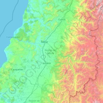
Name: Maule Region topographic map, elevation, terrain.
Location: Maule Region, Chile (-36.54362 -72.78638 -34.68453 -70.30761)
Average elevation: 908 m
Minimum elevation: 0 m
Maximum elevation: 4,855 m
Other topographic maps
Click on a map to view its topography, its elevation and its terrain.
Cerro Castillo
Chile > Magallanes and Chilean Antarctica Region > Provincia de Última Esperanza > Torres del Paine
Average elevation: 155 m
Santiago
Chile > Santiago Metropolitan Region > Provincia de Santiago > Santiago
The city lies in the center of the Santiago Basin, a large bowl-shaped valley consisting of broad and fertile lands surrounded by mountains. The city has a varying elevation, gradually increasing from 400 m (1,312 ft) in the western areas to more than 700 m (2,297 ft) in the eastern areas. Santiago's…
Average elevation: 724 m
Puerto Cisnes
Chile > Aysen del General Carlos Ibanez del Campo Region > Provincia de Aysén > Cisnes
Average elevation: 168 m
Duperre
Chile > Magallanes and Chilean Antarctica Region > Provincia de la Antártica Chilena > Cape Horn
Average elevation: 80 m
Isla Florencia
Chile > Aysen del General Carlos Ibanez del Campo Region > Provincia de Aysén > Cisnes
Average elevation: 13 m
Cerro Corona del Diablo
Chile > O'Higgins Region > Provincia de Colchagua > San Fernando
Average elevation: 4,051 m
Suriplaza
Chile > Arica y Parinacota Region > Provincia de Parinacota > General Lagos
Average elevation: 4,776 m
Clear water
Chile > Aysen del General Carlos Ibanez del Campo Region > Provincia de Capitán Prat > O’Higgins
Average elevation: 399 m
Chiuchiu
Chile > Antofagasta Region > Provincia de El Loa > Calama
San Francisco de Chiu Chiu, or simply Chiu Chiu, is a village located about 30 km (19 mi) northeast of the city of Calama, in El Loa Province of Chile's northern Antofagasta Region. It lies at an elevation of 2,525 m (8,284 ft) above sea level, close to the confluence of the Loa and Salado rivers.
Average elevation: 2,543 m
Sierra Colorada
Chile > Atacama Region > Provincia de Chañaral > Diego de Almagro
Average elevation: 4,816 m
Fitzroy Channel
Chile > Magallanes and Chilean Antarctica Region > Provincia de Magallanes > Río Verde
Average elevation: 83 m
Volcán Licancabur
Chile > Antofagasta Region > Provincia de El Loa > San Pedro de Atacama
The volcano is in the Puna de Atacama/Cordillera Occidental of the Andes. Politically, it is located in the Antofagasta Region of Chile and the Potosí Department of Bolivia; the border goes over Licancabur. Less than 20 kilometres (12 mi) south is the Llano del Chajnantor Observatory. San Pedro de Atacama is…
Average elevation: 5,285 m
La Laguna de Zapallar
Chile > Valparaiso Region > Provincia de Petorca > Zapallar
Average elevation: 58 m
Volcán Tátio
Chile > Antofagasta Region > Provincia de El Loa > San Pedro de Atacama
Average elevation: 4,850 m
Termas del Flaco
Chile > O'Higgins Region > Provincia de Colchagua > San Fernando
Average elevation: 2,033 m
Puerto Sánchez
Chile > Aysen del General Carlos Ibanez del Campo Region > Provincia de General Carrera > Río Ibáñez
Average elevation: 323 m
Los Cántaros
Chile > Santiago Metropolitan Region > Provincia de Chacabuco > Batuco
Average elevation: 493 m
Santuario de la Naturaleza y RENAMU Humedal Desembocadura Río Lluta
Chile > Arica and Parinacota Region > Provincia de Arica > Arica > Villa Frontera > Las Machas
Average elevation: 10 m
Piko Bay
Chile > Valparaiso Region > Easter Island Province > Easter Island > Hanga Roa
Average elevation: 32 m
Cerro Castillo
Chile > Region of Magallanes and Chilean Antarctica > Provincia de Tierra del Fuego > Timaukel
Average elevation: 814 m
Baños Morales
Chile > Santiago Metropolitan Region > Provincia de Cordillera > San José de Maipo
Average elevation: 2,269 m
Puerto Williams
Chile > Region of Magallanes and Chilean Antarctica > Provincia de la Antártica Chilena > Cape Horn
The climate of Puerto Williams is a temperate subpolar oceanic climate (Cfc) bordering closely on a tundra climate (ET) according to the Köppen climate classification. The summers are short and cool while the winters are long, wet, but moderate. Rainfall is around 512.3 mm (20 in) a year and temperatures are…
Average elevation: 151 m
Bahía Inglesa
Chile > Atacama Region > Provincia de Copiapó > Caldera
Bahia Inglesa ("English Bay") is a locality located near the port of Caldera in Atacama Region, Chile. It is situated at an average elevation of 10 meters above the sea level. As of 2017, it had a population of 535.
Average elevation: 10 m
Valle de la Luna
Chile > Antofagasta Region > Provincia de El Loa > San Pedro de Atacama
Average elevation: 2,531 m
Población Los Castaños 1
Chile > Araucanía Region > Provincia de Cautín > Vilcún > Cajón
Average elevation: 146 m
Ojo de Agua
Chile > Antofagasta Region > Provincia de Antofagasta > Antofagasta
Average elevation: 19 m
Zona Sur
Chile > Los Ríos Region > Provincia de Ranco > Río Bueno
Although many lakes can be found in the Andean and coastal regions of central Chile, the south (Sur de Chile) has the country's most lakes. Southern Chile stretches from below the Río Bío-Bío at about 37° south latitude to below Isla de Chiloé at about 43.4° south latitude. In this lake district of…
Average elevation: 399 m
Ocoa
Chile > Valparaiso Region > Provincia de Quillota > Hijuelas > La Sombra
Average elevation: 349 m
Cerro Torre
Chile > Magallanes and Chilean Antarctica Region > Provincia de Última Esperanza > Puerto Natales
Average elevation: 1,916 m
Volcán Parinacota
Chile > Arica y Parinacota Region > Provincia de Parinacota > Putre
Parinacota (in Hispanicized spelling), Parina Quta or Parinaquta is a dormant stratovolcano on the border of Bolivia and Chile. Together with Pomerape it forms the Nevados de Payachata volcanic chain. Part of the Central Volcanic Zone of the Andes, its summit reaches an elevation of 6,380 metres (20,930 ft)…
Average elevation: 5,808 m
Osorno Volcano
Chile > Los Lagos Region > Provincia de Llanquihue > Puerto Varas
The basalt and andesite lava flows generated during these eruptions reached both Lago Llanquihue and Lago Todos Los Santos. The upper slopes of the volcano are almost entirely covered in glaciers despite its very modest altitude and latitude, sustained by the substantial annual snowfall in the very moist…
Average elevation: 1,994 m
Volcán Aucanquilcha
Chile > Antofagasta Region > Provincia de El Loa > Ollagüe
At Aucanquilcha volcano there is some fumarolic activity, and sulfur deposits are found at the summit. Several sulfur mines lie in the complex. One mine at an altitude of 5,950 metres (19,520 ft) was opened in 1913 and remained in use from 1950 to 1992. It was the world's highest mine during that period.…
Average elevation: 5,808 m
Nueva Braunau
Chile > Los Lagos Region > Provincia de Llanquihue > Puerto Varas
Average elevation: 105 m
Peak
Chile > Region of Magallanes and Chilean Antarctica > Provincia de Magallanes > Punta Arenas
Average elevation: 48 m
Longovilo
Chile > Santiago Metropolitan Region > Provincia de Melipilla > San Pedro
Average elevation: 181 m
Monte San Valentin
Chile > Aysén Region > Provincia de Aysén > Aysén
There is some confusion about the elevation. It was originally estimated at 3,876m by Nordenskjold in 1921 but later thought to be 4,058m. The latter is the most commonly quoted elevation and is quoted here. A French group that climbed the San Valentin in 1993 included two surveyors, who calculated an…
Average elevation: 3,370 m
Tupungato
Chile > Santiago Metropolitan Region > Provincia de Cordillera > San José de Maipo
Average elevation: 6,002 m
Río Colorado
Chile > Santiago Metropolitan Region > Provincia de Cordillera > San José de Maipo
Average elevation: 1,407 m
Volcán Calbuco
Chile > Los Lagos Region > Provincia de Llanquihue > Puerto Varas
Calbuco (/kɑːlˈbuːkoʊ/ kahl-BOO-koh; Spanish: Volcán Calbuco, pronounced ) is a stratovolcano in southern Chile, located southeast of Llanquihue Lake and northwest of Chapo Lake, in the Los Lagos Region, and close to the cities of Puerto Varas and Puerto Montt. With an elevation of 2,015 meters above sea…
Average elevation: 1,581 m
Volcán Lautaro
Chile > Region of Magallanes and Chilean Antarctica > Provincia de Última Esperanza > Puerto Natales
Average elevation: 3,028 m
Los Loros
Chile > Valparaiso Region > Provincia de San Felipe de Aconcagua > Llay-Llay
Average elevation: 523 m
Cerro Paine Grande
Chile > XII Region of Magallanes and Chilean Antarctica > Torres del Paine
Average elevation: 1,907 m
Ritoque
Chile > Valparaiso Region > Provincia de Valparaíso > Quintero > Ritoque
Average elevation: 18 m
Puerto Varas
Chile > Los Lagos Region > Provincia de Llanquihue > Puerto Varas > Puerto Varas
Average elevation: 91 m
Marchigüe
Chile > O'Higgins Region > Provincia de Cardenal Caro > Marchigüe > Marchigüe
Average elevation: 150 m
Monte Fitz Roy
Chile > XII Region of Magallanes and Chilean Antarctica > Natales
Average elevation: 2,023 m
Salto Grande
Chile > XII Region of Magallanes and Chilean Antarctica > Torres del Paine
Average elevation: 104 m
Valle Nevado
Chile > Santiago Metropolitan Region > Provincia de Santiago > Lo Barnechea
Due to its elevation, Valle Nevado has a subalpine climate (Dfc, according to the Köppen climate classification, bordering on Dfb and ET), with drier summers and humid winters, with an average annual precipitation of 1,042 mm (41 in). Summers are chilly and dry, while winters are cold and snowy.
Average elevation: 2,811 m
Paine Oriente
Chile > Santiago Metropolitan Region > Provincia de Maipo > Paine
Average elevation: 402 m