
Make a donation
Gear up for your next adventure:
As an Amazon Associate, this site earns from qualifying purchases at no extra cost to you.
Thandrampet topographic map
Click on the map to display elevation.
Make a donation
Gear up for your next adventure:
As an Amazon Associate, this site earns from qualifying purchases at no extra cost to you.
About this map
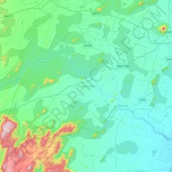
Name: Thandrampet topographic map, elevation, terrain.
Location: Thandrampet, Tiruvannamalai District, Tamil Nadu, India (11.98339 78.66224 12.24993 79.04281)
Average elevation: 258 m
Minimum elevation: 113 m
Maximum elevation: 1,022 m
Make a donation
Gear up for your next adventure:
As an Amazon Associate, this site earns from qualifying purchases at no extra cost to you.
Other topographic maps
Click on a map to view its topography, its elevation and its terrain.
Hosur
India > Tamil Nadu > Hosur
Hosur experiences a tropical savanna climate (Köppen climate classification) with distinct wet and dry seasons. Due to its high elevation, Hosur usually enjoys salubrious and moderate climate throughout the year, with occasional heat waves. The coolest month is January with an average low temperature of 17.1…
Average elevation: 859 m
Make a donation
Gear up for your next adventure:
As an Amazon Associate, this site earns from qualifying purchases at no extra cost to you.
Make a donation
Gear up for your next adventure:
As an Amazon Associate, this site earns from qualifying purchases at no extra cost to you.
Vellore Fort
India > Tamil Nadu > Vellore > Vellore
It is mentioned that "there is no such fort on the face of earth like the one in Vellore. It had a deep wet ditch (moat) where once 10,000 crocodiles swarmed, waiting to grab every intruder into this impregnable fort. It has huge double walls with bastions projecting irregularly, where two carts can be driven…
Average elevation: 214 m
Make a donation
Gear up for your next adventure:
As an Amazon Associate, this site earns from qualifying purchases at no extra cost to you.
Cuddalore
India > Tamil Nadu > Cuddalore
Cuddalore is located at 11°45′N 79°45′E / 11.75°N 79.75°E / 11.75; 79.75. It has an average elevation of 6 m (20 ft). The land is completely flat with large black and alluvial soil inland and coarse sand near the seashore. The sandstone deposits in the town are popular. The Pennayar River runs north of…
Average elevation: 8 m
Make a donation
Gear up for your next adventure:
As an Amazon Associate, this site earns from qualifying purchases at no extra cost to you.
Ambasamudram
India > Tamil Nadu > Ambasamudram
Maancholai Hills is located between elevations ranging from 1,000 to 1,500 metres. The Maancholai area is deep within the Western Ghats, within the Kalakad Mundanthurai Tiger Reserve in the Tirunelveli District. Located on top of the Manimuthar Dam and the Manimuthar Water Falls, the Maancholai area comprises…
Average elevation: 71 m
Make a donation
Gear up for your next adventure:
As an Amazon Associate, this site earns from qualifying purchases at no extra cost to you.
Make a donation
Gear up for your next adventure:
As an Amazon Associate, this site earns from qualifying purchases at no extra cost to you.
Sirkazhi
India > Tamil Nadu > Sirkali
Sirkazhi is located at 11°14′N 79°44′E / 11.23°N 79.73°E / 11.23; 79.73, on the eastern flank of the Kumbakonam-Shiyali ridge, which runs along the Kollidam River. Sirkazhi has an average elevation of 5.18 m (17.0 ft) above sea level and is located at 13 km (8.1 mi) west of Bay of Bengal. It…
Average elevation: 5 m
Make a donation
Gear up for your next adventure:
As an Amazon Associate, this site earns from qualifying purchases at no extra cost to you.
Kolukkumalai
India > Tamil Nadu > Bodinayakanur
Kolukkumalai is a small village/hamlet in Bodinayakanur Taluk in the Theni district of the Indian state of Tamil Nadu. It is home to the highest tea plantation in the world with the tea grown here possessing a special flavour and freshness because of the high altitude. It is located near Munnar in Idukki…
Average elevation: 1,726 m
Make a donation
Gear up for your next adventure:
As an Amazon Associate, this site earns from qualifying purchases at no extra cost to you.
Vaniyambadi
India > Tamil Nadu > Vaniyambadi
Vaniyambadi is located at 12.6872° N, 78.6303° E. It has an average elevation of 354 metres (1,161 ft) and lies in the Eastern Ghats region and on the banks of the Palar river. Yelagiri and Javadi Hills are located to the south of the town. By road Vaniyambadi is surrounded by Ambur and Tirupathur which are…
Average elevation: 371 m
Make a donation
Gear up for your next adventure:
As an Amazon Associate, this site earns from qualifying purchases at no extra cost to you.
Make a donation
Gear up for your next adventure:
As an Amazon Associate, this site earns from qualifying purchases at no extra cost to you.
Sulur
India > Tamil Nadu > Sulur
Sulur is located at 11°01′31″N 77°07′29″E / 11.0254°N 77.1246°E / 11.0254; 77.1246. It has an average elevation of 340 metres (1115 feet). Sulur is regarded as a pleasant town situated very close to the cities of Coimbatore "Manchester of South India" (19 km) and Tirupur (35 km). Thus it…
Average elevation: 371 m
Make a donation
Gear up for your next adventure:
As an Amazon Associate, this site earns from qualifying purchases at no extra cost to you.
Make a donation
Gear up for your next adventure:
As an Amazon Associate, this site earns from qualifying purchases at no extra cost to you.
Make a donation
Gear up for your next adventure:
As an Amazon Associate, this site earns from qualifying purchases at no extra cost to you.
Make a donation
Gear up for your next adventure:
As an Amazon Associate, this site earns from qualifying purchases at no extra cost to you.
Pallapalayam - Kannampalayam Canal
India > Tamil Nadu > Sulur > Kannampalayam
Average elevation: 381 m
Make a donation
Gear up for your next adventure:
As an Amazon Associate, this site earns from qualifying purchases at no extra cost to you.
Srivaikuntam
India > Tamil Nadu > Srivaikuntam
Tiruvaikuntam is located at 8°37′52″N 77°54′34″E / 8.63115°N 77.9095017°E / 8.63115; 77.9095017. It has an average elevation of 17 metres (55 feet). The town is located on the north bank of the Tamirabarani river. It is 30 km east of Tirunelveli , 30 km west of Tiruchendur and 39 km from Tuticorin.
Average elevation: 19 m
Make a donation
Gear up for your next adventure:
As an Amazon Associate, this site earns from qualifying purchases at no extra cost to you.
Tindivanam
India > Tamil Nadu > Tindivanam
Tindivanam is located at 12°15′N 79°39′E / 12.25°N 79.65°E / 12.25; 79.65. It has an average elevation of 58 metres (190 feet). Tindivanam is 120 km (75 mi) southwest from Chennai and 35 km (22 mi) northwest from Pondicherry. Tindivanam is one among the three sub-divisions of Viluppuram…
Average elevation: 44 m
Make a donation
Gear up for your next adventure:
As an Amazon Associate, this site earns from qualifying purchases at no extra cost to you.
Make a donation
Gear up for your next adventure:
As an Amazon Associate, this site earns from qualifying purchases at no extra cost to you.
Make a donation
Gear up for your next adventure:
As an Amazon Associate, this site earns from qualifying purchases at no extra cost to you.
Make a donation
Gear up for your next adventure:
As an Amazon Associate, this site earns from qualifying purchases at no extra cost to you.
Thengapattinam
India > Tamil Nadu > Vilavancode
Thengapattanam is located in the South western coast of India bordering the Arabian Sea to the west, western ghats to the north, and vast fertile plains with intermittent Rocky hills to the east. The town is 11 km into the Tamil Nadu border from Kerala. The Kerala state capital Thiruvananthapuram is 45 km away…
Average elevation: 17 m
Make a donation
Gear up for your next adventure:
As an Amazon Associate, this site earns from qualifying purchases at no extra cost to you.
Make a donation
Gear up for your next adventure:
As an Amazon Associate, this site earns from qualifying purchases at no extra cost to you.
Make a donation
Gear up for your next adventure:
As an Amazon Associate, this site earns from qualifying purchases at no extra cost to you.
Aravakurichi
India > Tamil Nadu > Aravakurichi
Aravakurichi is located at 10°46′N 77°55′E / 10.77°N 77.92°E / 10.77; 77.92. and has an average elevation of 174 m (571 ft). The town is located off the Varnasi - Kanyakumari National Highway 7 (India). The time zone is IST (UTC+5:30).
Average elevation: 171 m
Make a donation
Gear up for your next adventure:
As an Amazon Associate, this site earns from qualifying purchases at no extra cost to you.
Make a donation
Gear up for your next adventure:
As an Amazon Associate, this site earns from qualifying purchases at no extra cost to you.