
Hoogeveen topographic map
Interactive map
Click on the map to display elevation.
About this map
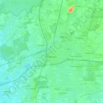
Name: Hoogeveen topographic map, elevation, terrain.
Location: Hoogeveen, Drenthe, Pays-Bas (52.65451 6.40360 52.80056 6.63241)
Average elevation: 12 m
Minimum elevation: 2 m
Maximum elevation: 51 m
Other topographic maps
Click on a map to view its topography, its elevation and its terrain.
De Tippe
Pays-Bas > Drenthe > Drogteropslagen > De Tippe
De Tippe, Drogteropslagen, De Wolden, Drenthe, Pays-Bas, 7701RW, Pays-Bas
Average elevation: 8 m
Wezuperbrug
Pays-Bas > Drenthe > Coevorden
Wezuperbrug, Coevorden, Drenthe, Pays-Bas
Average elevation: 20 m