
Chandigarh topographic map
Interactive map
Click on the map to display elevation.
About this map
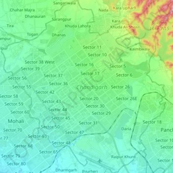
Name: Chandigarh topographic map, elevation, terrain.
Location: Chandigarh, India (30.66497 76.70499 30.79495 76.84903)
Average elevation: 343 m
Minimum elevation: 300 m
Maximum elevation: 511 m
Chandigarh is located by the foothills of the Shivalik Range of the Himalayas in northwest India. It covers an area of approximately 114 km2. It borders the states of Punjab and Haryana. The exact geographic coordinates of Chandigarh are 30°44′N 76°47′E / 30.74°N 76.79°E / 30.74; 76.79. It has an average elevation of 321 metres (1053 ft).
Other topographic maps
Click on a map to view its topography, its elevation and its terrain.
Bengaluru
India > Karnataka > Bangalore North
Bengaluru, Bangalore North, Bengaluru Urban District, Karnataka, India
Average elevation: 881 m
Chennai
India > Tamil Nadu > Chennai
Chennai, Chennai District, Tamil Nadu, India
Average elevation: 8 m
3d
India > Rajasthan > Ganganagar Tehsil > 1 LNP
3d, 1 LNP, Ganganagar Tehsil, Sri Ganganagar District, Rajasthan, India
Average elevation: 178 m
Gunjuru
India > Karnataka > Bangalore East
Gunjuru, Kachamaranahalli, Bangalore East, Bengaluru Urban, Karnataka, 560087, India
Average elevation: 884 m
Whitefield
India > Karnataka > Bangalore East > Bengaluru
Whitefield, Bengaluru, Bangalore East, Bengaluru Urban District, Karnataka, 560066, India
Average elevation: 875 m
Pune
India > Maharashtra > Pune City > Pune
Pune, Pune City, Pune District, Maharashtra, 411001, India
Average elevation: 641 m
Kolkata
Kolkata, Kolkata District, West Bengal, 700073, India
Average elevation: 5 m
Mysuru
India > Karnataka > Mysuru taluk
Mysuru, Mysuru taluk, Mysuru District, Karnataka, 570001, India
Average elevation: 727 m
Coimbatore
India > Tamil Nadu > Coimbatore North
Coimbatore, Coimbatore North, Coimbatore District, Tamil Nadu, 641001, India
Average elevation: 452 m
Kodigehalli
India > Karnataka > Bangalore East
Kodigehalli, Bangalore East, Bengaluru Urban, Karnataka, 560067, India
Average elevation: 881 m
Gurgaon
India > Haryana > Gurugram District
Gurgaon, Gurugram District, Haryana, India
Average elevation: 237 m
Kodaikanal
Kodaikanal, Dindigul District, Tamil Nadu, India
Average elevation: 869 m
Lucknow
India > Uttar Pradesh > Lucknow
Lucknow, Lucknow District, Uttar Pradesh, 226027, India
Average elevation: 120 m
Karaikudi
India > Tamil Nadu > Karaikkudi
Karaikudi, Karaikkudi, Sivagangai District, Tamil Nadu, 623001, India
Average elevation: 87 m
Pimpri-Chinchwad
India > Maharashtra > Haveli
Pimpri-Chinchwad, Haveli, Pune District, Maharashtra, 411089, India
Average elevation: 605 m
Western Ghats
Western Ghats, Idukki, Kerala, 685614, India
Average elevation: 2,225 m
Chhota Bhanuja
India > Rajasthan > Khamnor Tehsil
Chhota Bhanuja, Khamnor Tehsil, Rajsamand District, Rajasthan, 313321, India
Average elevation: 644 m
Chikodi taluk
Chikodi taluk, Belagavi District, Karnataka, India
Average elevation: 613 m
Narhe
India > Maharashtra > Bhor
Narhe, Bhor, Pune District, Maharashtra, India
Average elevation: 683 m
Nathdwara
India > Rajasthan > Nathdwara Tehsil
Nathdwara, Nathdwara Tehsil, Rajsamand District, Rajasthan, 313301, India
Average elevation: 590 m
Kukshi
India > Madhya Pradesh > Kukshi Tahsil > Kukshi
Kukshi, Kukshi Tahsil, Dhar District, Madhya Pradesh, 454331, India
Average elevation: 176 m