
Make a donation
Gear up for your next adventure:
As an Amazon Associate, this site earns from qualifying purchases at no extra cost to you.
Lichfield topographic map
Click on the map to display elevation.
Make a donation
Gear up for your next adventure:
As an Amazon Associate, this site earns from qualifying purchases at no extra cost to you.
About this map
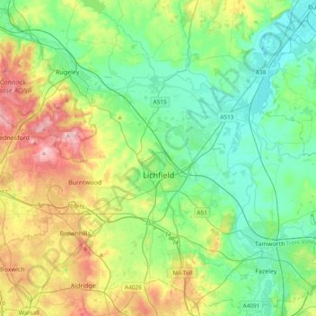
Name: Lichfield topographic map, elevation, terrain.
Location: Lichfield, Staffordshire, England, United Kingdom (52.58489 -1.96323 52.80779 -1.58629)
Average elevation: 103 m
Minimum elevation: 43 m
Maximum elevation: 241 m
Staffordshire trails, hiking, mountain biking, running and outdoor activities
Make a donation
Gear up for your next adventure:
As an Amazon Associate, this site earns from qualifying purchases at no extra cost to you.
Other topographic maps
Click on a map to view its topography, its elevation and its terrain.
College Gardens
United Kingdom > England > Staffordshire > Newcastle-under-Lyme > Madeley
Average elevation: 123 m
Tutbury Castle
United Kingdom > England > Staffordshire > East Staffordshire > Tutbury
Average elevation: 66 m
Burton upon Trent
United Kingdom > England > Staffordshire > East Staffordshire
Burton is about 109 miles (175 km) north west of London, about 30 miles north east of Birmingham, the UK's second largest city and about 23 miles east of the county town Stafford. It is at the easternmost border of the county of Staffordshire with Derbyshire, its suburbs and the course of the River Trent…
Average elevation: 69 m
Make a donation
Gear up for your next adventure:
As an Amazon Associate, this site earns from qualifying purchases at no extra cost to you.
Werrington
United Kingdom > England > Staffordshire > Staffordshire Moorlands
Average elevation: 229 m
Stubwood
United Kingdom > England > Staffordshire > East Staffordshire > Denstone
Average elevation: 113 m
Birch Cross
United Kingdom > England > Staffordshire > East Staffordshire > Marchington
Average elevation: 92 m
Make a donation
Gear up for your next adventure:
As an Amazon Associate, this site earns from qualifying purchases at no extra cost to you.
Biddulph Moor
United Kingdom > England > Staffordshire > Staffordshire Moorlands
Average elevation: 242 m
Make a donation
Gear up for your next adventure:
As an Amazon Associate, this site earns from qualifying purchases at no extra cost to you.
Wain Lea
United Kingdom > England > Staffordshire > Newcastle-under-Lyme > Harriseahead
Average elevation: 207 m
Weston Park
United Kingdom > England > Staffordshire > South Staffordshire > Weston under Lizard
Average elevation: 113 m
Make a donation
Gear up for your next adventure:
As an Amazon Associate, this site earns from qualifying purchases at no extra cost to you.
Make a donation
Gear up for your next adventure:
As an Amazon Associate, this site earns from qualifying purchases at no extra cost to you.
Stepping Stones
United Kingdom > England > Staffordshire > Staffordshire Moorlands
Average elevation: 224 m
Bottomhouse
United Kingdom > England > Staffordshire > Staffordshire Moorlands > Ipstones
Average elevation: 312 m
Make a donation
Gear up for your next adventure:
As an Amazon Associate, this site earns from qualifying purchases at no extra cost to you.
Apedale
United Kingdom > England > Staffordshire > Newcastle-under-Lyme > Chesterton
Average elevation: 168 m
Levedale
United Kingdom > England > Staffordshire > South Staffordshire > Penkridge
Average elevation: 98 m
Make a donation
Gear up for your next adventure:
As an Amazon Associate, this site earns from qualifying purchases at no extra cost to you.
Roughcote
United Kingdom > England > Staffordshire > Staffordshire Moorlands > Caverswall
Average elevation: 217 m
Blackshaw Moor
United Kingdom > England > Staffordshire > Staffordshire Moorlands > Thorncliffe
Average elevation: 282 m
Make a donation
Gear up for your next adventure:
As an Amazon Associate, this site earns from qualifying purchases at no extra cost to you.
Castle Ring
United Kingdom > England > Staffordshire > Cannock Chase > Cannock Wood
It is the highest point on The Chase with an elevation of 242 metres (794 ft).
Average elevation: 191 m
Make a donation
Gear up for your next adventure:
As an Amazon Associate, this site earns from qualifying purchases at no extra cost to you.
Newcastle-under-Lyme
United Kingdom > England > Staffordshire > Newcastle-under-Lyme
Average elevation: 147 m
Bignall End
United Kingdom > England > Staffordshire > Newcastle-under-Lyme > Audley
Average elevation: 150 m
Make a donation
Gear up for your next adventure:
As an Amazon Associate, this site earns from qualifying purchases at no extra cost to you.
Bednall
United Kingdom > England > Staffordshire > South Staffordshire > Bednall
Average elevation: 118 m
Halfpenny Green
United Kingdom > England > Staffordshire > South Staffordshire
Average elevation: 91 m
Blithfield Reservoir
United Kingdom > England > Staffordshire > East Staffordshire > Admaston
Average elevation: 108 m
Make a donation
Gear up for your next adventure:
As an Amazon Associate, this site earns from qualifying purchases at no extra cost to you.
Betley Mere
United Kingdom > England > Staffordshire > Borough of Newcastle-under-Lyme > Wrinehill > Cracow Moss
Average elevation: 81 m
Horton
United Kingdom > England > Staffordshire > Staffordshire Moorlands > Gratton
Average elevation: 199 m
Make a donation
Gear up for your next adventure:
As an Amazon Associate, this site earns from qualifying purchases at no extra cost to you.
Merryton Low
United Kingdom > England > Staffordshire > Staffordshire Moorlands
Average elevation: 412 m
Wood Lane
United Kingdom > England > Staffordshire > Newcastle-under-Lyme > Bignall Hill
Average elevation: 168 m
Make a donation
Gear up for your next adventure:
As an Amazon Associate, this site earns from qualifying purchases at no extra cost to you.
Rushton Spencer
United Kingdom > England > Staffordshire > Staffordshire Moorlands
Average elevation: 204 m
Calf Heath
United Kingdom > England > Staffordshire > South Staffordshire > Hatherton Junction
Average elevation: 113 m
Chasewater
United Kingdom > England > Staffordshire > Lichfield > Burntwood > Chasetown
Average elevation: 155 m
Make a donation
Gear up for your next adventure:
As an Amazon Associate, this site earns from qualifying purchases at no extra cost to you.
Wetley Rocks
United Kingdom > England > Staffordshire > Staffordshire Moorlands
Average elevation: 229 m
Old Hannah's Hole
United Kingdom > England > Staffordshire > Staffordshire Moorlands > Wetton
Average elevation: 276 m
Make a donation
Gear up for your next adventure:
As an Amazon Associate, this site earns from qualifying purchases at no extra cost to you.
Make a donation
Gear up for your next adventure:
As an Amazon Associate, this site earns from qualifying purchases at no extra cost to you.
Moneystone
United Kingdom > England > Staffordshire > Staffordshire Moorlands > Cotton
Average elevation: 231 m
Biddulph Grange Country Park
United Kingdom > England > Staffordshire > Staffordshire Moorlands > Biddulph > Biddulph Moor
Average elevation: 229 m
Make a donation
Gear up for your next adventure:
As an Amazon Associate, this site earns from qualifying purchases at no extra cost to you.
Moneystone Quarry
United Kingdom > England > Staffordshire > Staffordshire Moorlands > Kingsley > Whiston Eaves
Average elevation: 202 m
Rudyard Lake
United Kingdom > England > Staffordshire > Staffordshire Moorlands > Rudyard > Horton
Average elevation: 205 m
Hales Hall Pool
United Kingdom > England > Staffordshire > Staffordshire Moorlands > Cheadle
Average elevation: 182 m
Make a donation
Gear up for your next adventure:
As an Amazon Associate, this site earns from qualifying purchases at no extra cost to you.
Mottey Meadows NNR
United Kingdom > England > Staffordshire > South Staffordshire > Wheaton Aston
Average elevation: 110 m
Brown Edge
United Kingdom > England > Staffordshire > Staffordshire Moorlands
Average elevation: 197 m
Make a donation
Gear up for your next adventure:
As an Amazon Associate, this site earns from qualifying purchases at no extra cost to you.
Whiston
United Kingdom > England > Staffordshire > South Staffordshire > Penkridge
Average elevation: 95 m
Cellarhead
United Kingdom > England > Staffordshire > Staffordshire Moorlands
Average elevation: 240 m
Make a donation
Gear up for your next adventure:
As an Amazon Associate, this site earns from qualifying purchases at no extra cost to you.
Whitmore Heath
United Kingdom > England > Staffordshire > Newcastle-under-Lyme > Whitmore
Average elevation: 141 m
Make a donation
Gear up for your next adventure:
As an Amazon Associate, this site earns from qualifying purchases at no extra cost to you.
Birks Wood
United Kingdom > England > Staffordshire > Newcastle-under-Lyme > Shraleybrook
Average elevation: 109 m
Gratwich
United Kingdom > England > Staffordshire > East Staffordshire > Kingstone
Average elevation: 143 m
Make a donation
Gear up for your next adventure:
As an Amazon Associate, this site earns from qualifying purchases at no extra cost to you.
Hope
United Kingdom > England > Staffordshire > Staffordshire Moorlands > Alstonefield
Average elevation: 274 m
Burgess Brook
United Kingdom > England > Staffordshire > Newcastle-under-Lyme
Average elevation: 149 m
Make a donation
Gear up for your next adventure:
As an Amazon Associate, this site earns from qualifying purchases at no extra cost to you.
Lutley
United Kingdom > England > Staffordshire > South Staffordshire > Enville
Average elevation: 100 m
Make a donation
Gear up for your next adventure:
As an Amazon Associate, this site earns from qualifying purchases at no extra cost to you.
Make a donation
Gear up for your next adventure:
As an Amazon Associate, this site earns from qualifying purchases at no extra cost to you.