
Fussa topographic map
Interactive map
Click on the map to display elevation.
About this map
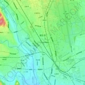
Name: Fussa topographic map, elevation, terrain.
Location: Fussa, Tokyo, Japan (35.71207 139.31387 35.75485 139.35987)
Average elevation: 126 m
Minimum elevation: 98 m
Maximum elevation: 192 m
Fussa is approximately in the geographic center of Tokyo Metropolis, on the Musashino Terrace, bordered by the floodplains of the Tama River. The land slopes gently from north to south, with an elevation of 124 meters above sea level at the location of the city hall, which is almost at the geographic center of the city area. The highest elevation is 143.5 meters in the northeast, and the lowest is 104 meters in the southwest. The area along the river is home to many parks and almost 300 cherry blossom trees, recreational facilities and bicycle paths.
Other topographic maps
Click on a map to view its topography, its elevation and its terrain.
Mount Fuji
Japan > Sunto County > Oyama
Mount Fuji, Oyama, Sunto County, Shizuoka Prefecture, Chubu Region, Japan
Average elevation: 3,261 m
Observation Deck (North Terminal)
Observation Deck (North Terminal), Osakaden, Itami, Hyogo Prefecture, Japan
Average elevation: 21 m
Lake Ashi
Japan > Ashigarashimo County > Hakone
Lake Ashi, Hakone, Ashigarashimo County, Kanagawa Prefecture, Japan
Average elevation: 869 m
Nishi Mera
Nishi Mera, Koyu County, Miyazaki Prefecture, Japan
Average elevation: 656 m
Maborikaigan 4-chome Park
Maborikaigan 4-chome Park, Maboricho 3-chome, Yokosuka, Kanagawa Prefecture, 238-8550, Japan
Average elevation: 22 m
Ibaraki
Ibaraki, Higashiibaraki County, Ibaraki Prefecture, 311-3116, Japan
Average elevation: 26 m
Lake Sanaru
Lake Sanaru, Hamamatsu, Shizuoka Prefecture, Chubu Region, Japan
Average elevation: 16 m
Motoyama
Motoyama, Nagaoka County, Kochi Prefecture, 781-3601, Japan
Average elevation: 679 m
Setouchi
Setouchi, Oshima County, Kagoshima Prefecture, Japan
Average elevation: 26 m
Higashishirakawa
Higashishirakawa, Kamo County, Gifu Prefecture, Chubu Region, 509-1392, Japan
Average elevation: 658 m