
Make a donation
Gear up for your next adventure:
As an Amazon Associate, this site earns from qualifying purchases at no extra cost to you.
Río Tambo topographic map
Click on the map to display elevation.
Make a donation
Gear up for your next adventure:
As an Amazon Associate, this site earns from qualifying purchases at no extra cost to you.
About this map
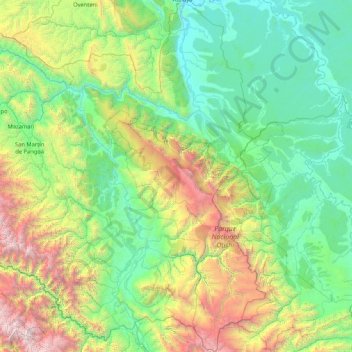
Name: Río Tambo topographic map, elevation, terrain.
Location: Río Tambo, Satipo, Junín, Perú (-12.38699 -74.70202 -10.73401 -73.35513)
Average elevation: 1,174 m
Minimum elevation: 205 m
Maximum elevation: 4,901 m
Make a donation
Gear up for your next adventure:
As an Amazon Associate, this site earns from qualifying purchases at no extra cost to you.
Other topographic maps
Click on a map to view its topography, its elevation and its terrain.
Make a donation
Gear up for your next adventure:
As an Amazon Associate, this site earns from qualifying purchases at no extra cost to you.
Make a donation
Gear up for your next adventure:
As an Amazon Associate, this site earns from qualifying purchases at no extra cost to you.
La Merced
Perú > Junín > Chanchamayo
La ciudad en un importante centro comercial agrícola de la selva central. Está a una altitud de 750 m.s.n.m. sobre la orilla occidental del río Chanchamayo, que luego se convierte en el río Perené. Las áreas circundantes de la ciudad cuentan con cascadas, ríos y bosque de selva con abundante vida silvestre.
Average elevation: 1,079 m
Laguna de Paca
La Laguna de Paca es un lago de montaña del Perú situado en la provincia de Jauja en el departamento de Junín, a unos 3.5 km al norte de la ciudad de Jauja. Se encuentra a 3.418 metros de altitud, presenta una extensión de 21.40 km² y tiene una capacidad de 85.50 mil m³.
Average elevation: 3,420 m
Make a donation
Gear up for your next adventure:
As an Amazon Associate, this site earns from qualifying purchases at no extra cost to you.
Rajuntay
Perú > Junín > Marcapomacocha
Rajuntay o Raujunte es una montaña del Perú con una altitud de 5,475 m s. n. m. Está situada en los Andes del Perú, en la provincia de Yauli en el departamento de Junín.
Average elevation: 4,931 m
Make a donation
Gear up for your next adventure:
As an Amazon Associate, this site earns from qualifying purchases at no extra cost to you.
Make a donation
Gear up for your next adventure:
As an Amazon Associate, this site earns from qualifying purchases at no extra cost to you.
Make a donation
Gear up for your next adventure:
As an Amazon Associate, this site earns from qualifying purchases at no extra cost to you.
Make a donation
Gear up for your next adventure:
As an Amazon Associate, this site earns from qualifying purchases at no extra cost to you.
Make a donation
Gear up for your next adventure:
As an Amazon Associate, this site earns from qualifying purchases at no extra cost to you.
Puerto Ocopa
Es una de las comunidades nativas más grandes con las que cuenta el distrito de Río Tambo. Se encuentra a una altitud de 358 m s. n. m.
Average elevation: 428 m
Make a donation
Gear up for your next adventure:
As an Amazon Associate, this site earns from qualifying purchases at no extra cost to you.
Make a donation
Gear up for your next adventure:
As an Amazon Associate, this site earns from qualifying purchases at no extra cost to you.
San Martín de Pangoa
San Martín de Pangoa es una localidad peruana ubicada en la región Junín, provincia de Satipo, distrito de Pangoa. Es asimismo capital del distrito de Pangoa. Se encuentra a una altitud de 676 m s. n. m. Tiene una población de 4246 habitantes en 1993.
Average elevation: 831 m
Make a donation
Gear up for your next adventure:
As an Amazon Associate, this site earns from qualifying purchases at no extra cost to you.
Make a donation
Gear up for your next adventure:
As an Amazon Associate, this site earns from qualifying purchases at no extra cost to you.
Make a donation
Gear up for your next adventure:
As an Amazon Associate, this site earns from qualifying purchases at no extra cost to you.
Make a donation
Gear up for your next adventure:
As an Amazon Associate, this site earns from qualifying purchases at no extra cost to you.
Huancayo
Debido a su latitud (12° LS), Huancayo debería tener un clima cálido. Sin embargo, la presencia de la Cordillera de los Andes y la altitud de la ciudad (3250 m s. n. m.) causan grandes variaciones en el clima. Huancayo tiene un clima templado subhúmedo pero inestable durante todo el año, variando entre…
Average elevation: 3,818 m
Make a donation
Gear up for your next adventure:
As an Amazon Associate, this site earns from qualifying purchases at no extra cost to you.
Make a donation
Gear up for your next adventure:
As an Amazon Associate, this site earns from qualifying purchases at no extra cost to you.
Make a donation
Gear up for your next adventure:
As an Amazon Associate, this site earns from qualifying purchases at no extra cost to you.
Make a donation
Gear up for your next adventure:
As an Amazon Associate, this site earns from qualifying purchases at no extra cost to you.
Make a donation
Gear up for your next adventure:
As an Amazon Associate, this site earns from qualifying purchases at no extra cost to you.
Make a donation
Gear up for your next adventure:
As an Amazon Associate, this site earns from qualifying purchases at no extra cost to you.
Make a donation
Gear up for your next adventure:
As an Amazon Associate, this site earns from qualifying purchases at no extra cost to you.
Nevado Huaytapallana
El nevado Huaytapallana tiene una altitud en su pico más alto de 5.557 metros. Su segundo pico, el Yanahucsha, mide 5.530 metros. El área total de la zona comprende 378,40 km² de superficie. Además, en la cordillera cabe destacar numerosos picos, entre los que se encuentran los siguientes.
Average elevation: 5,088 m
Make a donation
Gear up for your next adventure:
As an Amazon Associate, this site earns from qualifying purchases at no extra cost to you.
Make a donation
Gear up for your next adventure:
As an Amazon Associate, this site earns from qualifying purchases at no extra cost to you.
Make a donation
Gear up for your next adventure:
As an Amazon Associate, this site earns from qualifying purchases at no extra cost to you.
Make a donation
Gear up for your next adventure:
As an Amazon Associate, this site earns from qualifying purchases at no extra cost to you.