
赤牛岳 topographic map
Interactive map
Click on the map to display elevation.
About this map
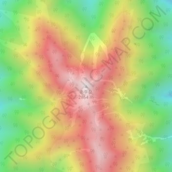
Name: 赤牛岳 topographic map, elevation, terrain.
Location: 赤牛岳, 富山市, 富山県, 日本 (36.46155 137.60324 36.46165 137.60334)
Average elevation: 2,434 m
Minimum elevation: 1,982 m
Maximum elevation: 2,860 m
赤牛岳(あかうしだけ)は、飛騨山脈中部にある標高2,864mの山。山域は1934年(昭和9年)12月4日に中部山岳国立公園の特別保護地区に指定され、日本二百名山に選定されている山である。
Other topographic maps
Click on a map to view its topography, its elevation and its terrain.