
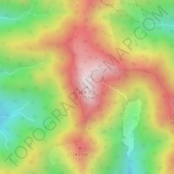
越中沢岳 topographic map
Interactive map
Click on the map to display elevation.
About this map
Name: 越中沢岳 topographic map, elevation, terrain.
Location: 越中沢岳, 富山市, 富山県, 日本 (36.51499 137.58297 36.51509 137.58307)
Average elevation: 2,160 m
Minimum elevation: 1,752 m
Maximum elevation: 2,571 m
越中沢岳(えっちゅうさわたけ)は富山県富山市にある山。立山連峰の主尾根上の山であり、標高は2591.4m。富山県登山連盟の富山の百山の一つ。
Other topographic maps
Click on a map to view its topography, its elevation and its terrain.