
Kota topographic map
Interactive map
Click on the map to display elevation.
About this map
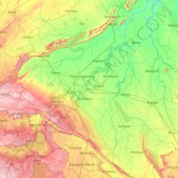
Name: Kota topographic map, elevation, terrain.
Location: Kota, Rajasthan, India (24.54335 75.61720 25.84879 76.59696)
Average elevation: 309 m
Minimum elevation: 181 m
Maximum elevation: 587 m
Other topographic maps
Click on a map to view its topography, its elevation and its terrain.
3d
India > Rajasthan > Ganganagar Tehsil > 1 LNP
3d, 1 LNP, Ganganagar Tehsil, Sri Ganganagar District, Rajasthan, India
Average elevation: 178 m
Jaipur
India > Rajasthan > Jaipur Tehsil
Jaipur, Jaipur Municipal Corporation, Jaipur Tehsil, Jaipur District, Rajasthan, 302001, India
Average elevation: 408 m
Jaisamand
India > Rajasthan > Sarada Tehsil
Jaisamand, Sarada Tehsil, Salumbar District, Rajasthan, India
Average elevation: 306 m
Gordhanpura
India > Rajasthan > Kotpuli Tehsil
Gordhanpura, Kotpuli Tehsil, Jaipur District, Rajasthan, India
Average elevation: 374 m
Dungarpur
India > Rajasthan > Dungarpur Tehsil
Dungarpur, Dungarpur Tehsil, Dungarpur District, Rajasthan, 314001, India
Average elevation: 299 m
Aspur
India > Rajasthan > Raipur Tehsil
Aspur, Raipur Tehsil, Bhilwara District, Rajasthan, India
Average elevation: 500 m
Sujangarh
India > Rajasthan > Sujangarh Tehsil
Sujangarh, Sujangarh Tehsil, Churu District, Rajasthan, 331507, India
Average elevation: 318 m
Tonk
India > Rajasthan > Tonk Tehsil
Tonk, Tonk Tehsil, Tonk District, Rajasthan, 304001, India
Average elevation: 282 m
Khamnor
India > Rajasthan > Khamnor Tehsil
Khamnor, Khamnor Tehsil, Rajsamand District, Rajasthan, 313322, India
Average elevation: 617 m
Behror
India > Rajasthan > Behror Tehsil
Behror, Behror Tehsil, Kotputli-Behror District, Rajasthan, 301700, India
Average elevation: 318 m
Mahi Reservoir
India > Rajasthan > Banswara Tehsil > Katiyor
Mahi Reservoir, Katiyor, Banswara Tehsil, Banswara District, Rajasthan, India
Average elevation: 296 m
Jodhpur
India > Rajasthan > Jodhpur Tehsil
Jodhpur, Jodhpur Tehsil, Jodhpur District, Rajasthan, India
Average elevation: 238 m
Bahadurpura
India > Rajasthan > Viratnagar Tehsil > Surajpura
Bahadurpura, Surajpura, Viratnagar Tehsil, Jaipur District, Rajasthan, India
Average elevation: 410 m
Abhanpur
India > Rajasthan > Tijara Tehsil
Abhanpur, Tijara Tehsil, Kherthal-Tijara District, Rajasthan, India
Average elevation: 294 m
Chhota Bhanuja
India > Rajasthan > Khamnor Tehsil
Chhota Bhanuja, Khamnor Tehsil, Rajsamand District, Rajasthan, 313321, India
Average elevation: 644 m
Nathdwara
India > Rajasthan > Nathdwara Tehsil
Nathdwara, Nathdwara Tehsil, Rajsamand District, Rajasthan, 313301, India
Average elevation: 590 m
Jaisalmer Tehsil
Jaisalmer Tehsil, Jaisalmer District, Rajasthan, India
Average elevation: 140 m
Bor Baori
India > Rajasthan > Begun Tehsil > Turkari
Bor Baori, Turkari, Begun Tehsil, Chittorgarh District, Rajasthan, India
Average elevation: 401 m
Sheoganj
India > Rajasthan > Sheoganj Tehsil
Sheoganj, Sheoganj Tehsil, Sirohi District, Rajasthan, 306902, India
Average elevation: 271 m
Nosal
India > Rajasthan > Roopangarh Tehsil
Nosal, Roopangarh Tehsil, Ajmer District, Rajasthan, 305814, India
Average elevation: 382 m
Didwana
India > Rajasthan > Didwana Tehsil
Didwana, Didwana Tehsil, Didwalna-Kuchaman District, Rajasthan, 341300, India
Average elevation: 343 m
Udaipur
India > Rajasthan > Girwa Tehsil
Udaipur, Girwa Tehsil, Udaipur District, Rajasthan, 313001, India
Average elevation: 656 m
Sariska
India > Rajasthan > Thanagazi Tehsil
Sariska, Thanagazi Tehsil, Alwar District, Rajasthan, India
Average elevation: 400 m
Bundi
India > Rajasthan > Bundi Tehsil
Bundi, Bundi Tehsil, Bundi District, Rajasthan, 323001, India
Average elevation: 284 m
Madho Singh Circle
India > Rajasthan > Jaipur Tehsil > Jaipur
Madho Singh Circle, Bani Park, Jaipur, Jaipur Municipal Corporation, Jaipur Tehsil, Jaipur District, Rajasthan, 302006, India
Average elevation: 447 m
Piplantri
India > Rajasthan > Rajsamand Tehsil
Piplantri, Rajsamand Tehsil, Rajsamand District, Rajasthan, India
Average elevation: 661 m
Vanasthali
India > Rajasthan > Niwai Tehsil
Vanasthali, Niwai Tehsil, Tonk District, Rajasthan, 304022, India
Average elevation: 312 m
Neelkanth
India > Rajasthan > Ahore Tehsil
Neelkanth, Ahore Tehsil, Jalore District, Rajasthan, India
Average elevation: 146 m
Jajiwal Gehlota
India > Rajasthan > Jodhpur Tehsil
Jajiwal Gehlota, Jodhpur Tehsil, Jodhpur District, Rajasthan, India
Average elevation: 222 m
(Shree Pravshnath park )Prabhu Pravshnath nagar pal balaji
India > Rajasthan > Jodhpur Tehsil > Jodhpur
(Shree Pravshnath park )Prabhu Pravshnath nagar pal balaji, 82, Jodhpur, Jodhpur Tehsil, Jodhpur District, Rajasthan, 342001, India
Average elevation: 231 m
Ratangarh
India > Rajasthan > Ratangarh Tehsil
Ratangarh, Ratangarh Tehsil, Churu District, Rajasthan, 331022, India
Average elevation: 316 m
Todabhim Tehsil
Todabhim Tehsil, Gangapur City District, Rajasthan, India
Average elevation: 247 m
Balal
India > Rajasthan > Sardarshahar Tehsil
Balal, Sardarshahar Tehsil, Churu District, Rajasthan, India
Average elevation: 246 m
Peeploon
India > Rajasthan > Siwana Tehsil
Peeploon, Siwana Tehsil, Balotra District, Rajasthan, India
Average elevation: 264 m
Rampura
India > Rajasthan > Shahpura Tehsil
Rampura, Shahpura Tehsil, Jaipur(Rural) District, Rajasthan, India
Average elevation: 438 m
Musepur
India > Rajasthan > Tijara Tehsil > Phullabas
Musepur, Phullabas, Tijara Tehsil, Kherthal-Tijara District, Rajasthan, India
Average elevation: 286 m
Mount Abu
India > Rajasthan > Abu Road Tehsil
Mount Abu, Abu Road Tehsil, Sirohi District, Rajasthan, 307500, India
Average elevation: 914 m
Kalwara
India > Rajasthan > Sanganer Tehsil
Kalwara, Sanganer Tehsil, Jaipur District, Rajasthan, 302037, India
Average elevation: 360 m
Kashmir
India > Rajasthan > Sheo Tehsil
Kashmir, Sheo Tehsil, Barmer District, Rajasthan, India
Average elevation: 226 m
Sangath
India > Rajasthan > Badgaon Tehsil
Sangath, Badgaon Tehsil, Udaipur District, Rajasthan, India
Average elevation: 750 m
Bigod
India > Rajasthan > Mandalgarh Tehsil
Bigod, Mandalgarh Tehsil, Bhilwara District, Rajasthan, India
Average elevation: 363 m
Ajmer
India > Rajasthan > Ajmer Tehsil
Ajmer, Ajmer Tehsil, Ajmer District, Rajasthan, India
Average elevation: 523 m
Bhitarli Ki Ganwari
India > Rajasthan > Neem Ka Thana Tehsil > Ganwari
Bhitarli Ki Ganwari, Ganwari, Neem Ka Thana Tehsil, Neem Ka Thana District, Rajasthan, India
Average elevation: 542 m
9DD
India > Rajasthan > Padampur Tehsil
9DD, Padampur Tehsil, Sri Ganganagar District, Rajasthan, India
Average elevation: 166 m
Eral
India > Rajasthan > Chittaurgarh Tehsil
Eral, Chittaurgarh Tehsil, Chittorgarh District, Rajasthan, India
Average elevation: 424 m
Leswa
India > Rajasthan > Pushkar Tehsil
Leswa, Pushkar Tehsil, Ajmer District, Rajasthan, 305201, India
Average elevation: 403 m
Desert National Park (Thar)
India > Rajasthan > Fatehgarh Tehsil
Desert National Park (Thar), Fatehgarh Tehsil, Jaisalmer District, Rajasthan, 345027, India
Average elevation: 164 m
Sawai Madhopur
India > Rajasthan > Sawai Madhopur Tehsil
Sawai Madhopur, Sawai Madhopur Tehsil, Sawai Madhopur District, Rajasthan, 322021, India
Average elevation: 284 m