
Brandenburg topographic map
Interactive map
Click on the map to display elevation.
About this map
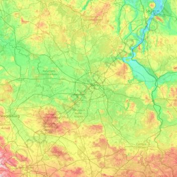
Name: Brandenburg topographic map, elevation, terrain.
Location: Brandenburg, Germany (51.35906 11.26623 53.55909 14.76582)
Average elevation: 68 m
Minimum elevation: -2 m
Maximum elevation: 314 m
Other topographic maps
Click on a map to view its topography, its elevation and its terrain.
Frankfurt am Main
Germany > Hesse > Frankfurt am Main
Frankfurt am Main, Hesse, 60311, Germany
Average elevation: 162 m
Stuttgart
Germany > Baden-Württemberg > Stuttgart
Stuttgart, Regierungsbezirk Stuttgart, Baden-Württemberg, 70173, Germany
Average elevation: 353 m
Lauchröden
Germany > Thuringia > Wartburgkreis
Lauchröden, Gerstungen, Wartburgkreis, Thuringia, 99819, Germany
Average elevation: 242 m
Aachen
Germany > North Rhine-Westphalia > Städteregion Aachen
Aachen, Städteregion Aachen, North Rhine-Westphalia, Germany
Average elevation: 225 m
Cologne
Germany > North Rhine – Westphalia
Cologne, North Rhine-Westphalia, Germany
Average elevation: 69 m
Oberkatz
Germany > Thuringia > Landkreis Schmalkalden-Meiningen > Kaltennordheim
Oberkatz, Kaltennordheim, Hohe Rhön, Landkreis Schmalkalden-Meiningen, Thuringia, Germany
Average elevation: 538 m
Alperstedt
Germany > Thuringia > Landkreis Sömmerda
Alperstedt, Gramme-Vippach, Landkreis Sömmerda, Thuringia, 99195, Germany
Average elevation: 159 m
Saalbach
Germany > Baden-Württemberg > Landkreis Karlsruhe
Saalbach, Landkreis Karlsruhe, Baden-Württemberg, Germany
Average elevation: 142 m
Hohen Viecheln
Germany > Mecklenburg-Vorpommern > Nordwestmecklenburg
Hohen Viecheln, Dorf Mecklenburg-Bad Kleinen, Nordwestmecklenburg, Mecklenburg-Vorpommern, Germany
Average elevation: 46 m
Kleiner Brombachsee
Germany > Bavaria > Weißenburg-Gunzenhausen > Langlau
Kleiner Brombachsee, Langlau, Pfofeld, Gunzenhausen (VGem), Weißenburg-Gunzenhausen, Bavaria, Germany
Average elevation: 427 m
Landkreis Weimarer Land
Landkreis Weimarer Land, Thuringia, Germany
Average elevation: 291 m
Mariental
Germany > Lower Saxony > Landkreis Helmstedt
Mariental, Samtgemeinde Grasleben, Landkreis Helmstedt, Lower Saxony, Germany
Average elevation: 142 m
Möhnesee
Germany > North Rhine – Westphalia > Kreis Soest
Möhnesee, Kreis Soest, North Rhine – Westphalia, 59519, Germany
Average elevation: 265 m
Ismaninger Speichersee und Fischteiche
Germany > Bavaria > Landkreis München > Unterföhring
Ismaninger Speichersee und Fischteiche, Unterföhring, Kirchheim bei München, Landkreis München, Bavaria, Germany
Average elevation: 496 m
Elten
Germany > North Rhine – Westphalia > Kreis Kleve > Emmerich on the Rhine
Elten, Emmerich on the Rhine, Kreis Kleve, North Rhine – Westphalia, Germany
Average elevation: 21 m
Langeneß
Germany > Schleswig-Holstein > Northern Friesland > Langeneß
Langeneß, Pellworm, Northern Friesland, Schleswig-Holstein, 25863, Germany
Average elevation: 0 m
Nürburg
Germany > Rhineland-Palatinate > Landkreis Ahrweiler
Nürburg, Adenau, Landkreis Ahrweiler, Rhineland-Palatinate, Germany
Average elevation: 560 m
Ergoldsbach
Germany > Bavaria > Landkreis Landshut
Ergoldsbach, Ergoldsbach (VGem), Landkreis Landshut, Bavaria, 84061, Germany
Average elevation: 454 m
99718
Germany > Thuringia > Kyffhäuserkreis > Wasserthaleben
99718, Wasserthaleben, Greußen, Kyffhäuserkreis, Thuringia, Germany
Average elevation: 235 m
Bremen
Germany > Free Hanseatic City of Bremen
Bremen, Free Hanseatic City of Bremen, Germany
Average elevation: 11 m
Illertissen
Germany > Bavaria > Landkreis Neu-Ulm
Illertissen, Landkreis Neu-Ulm, Bavaria, 89257, Germany
Average elevation: 522 m
Wind
Germany > Bavaria > Landkreis Bamberg
Wind, Pommersfelden, Landkreis Bamberg, Bavaria, 96178, Germany
Average elevation: 284 m
Waldesch
Germany > Rhineland-Palatinate > Landkreis Mayen-Koblenz
Waldesch, Rhein-Mosel, Landkreis Mayen-Koblenz, Rhineland-Palatinate, 56323, Germany
Average elevation: 331 m
Horn-Bad Meinberg
Germany > North Rhine – Westphalia > Kreis Lippe
Horn-Bad Meinberg, Kreis Lippe, North Rhine – Westphalia, 32805, Germany
Average elevation: 238 m
Meinberg
Germany > Bavaria > Landkreis Bayreuth > Goldkronach
Meinberg, Goldkronach, Landkreis Bayreuth, Bavaria, 95497, Germany
Average elevation: 450 m
Bad Orb
Germany > Hesse > Main-Kinzig-Kreis
Bad Orb, Main-Kinzig-Kreis, Hesse, 63619, Germany
Average elevation: 325 m
Bad Saulgau
Germany > Baden-Württemberg > Landkreis Sigmaringen
Bad Saulgau, Verwaltungsgemeinschaft Bad Saulgau, Landkreis Sigmaringen, Baden-Württemberg, 88348, Germany
Average elevation: 613 m
Langen
Germany > Hesse > Landkreis Offenbach
Langen, Landkreis Offenbach, Hesse, 63225, Germany
Average elevation: 137 m
Ebringen
Germany > Baden-Württemberg > Landkreis Breisgau-Hochschwarzwald
Ebringen, VVG der Gemeinde Schallstadt, Landkreis Breisgau-Hochschwarzwald, Baden-Württemberg, 79285, Germany
Average elevation: 354 m
Diedorf
Germany > Bavaria > Augsburg (district)
Diedorf, Augsburg (district), Bavaria, 86420, Germany
Average elevation: 506 m
Oberhorbach
Germany > North Rhine – Westphalia > Rhein-Sieg-Kreis > Neunkirchen-Seelscheid
Oberhorbach, Eischeid, Neunkirchen-Seelscheid, Rhein-Sieg-Kreis, North Rhine – Westphalia, 53819, Germany
Average elevation: 183 m
Klein Förste
Germany > Lower Saxony > Landkreis Hildesheim
Klein Förste, Harsum, Landkreis Hildesheim, Lower Saxony, 31180, Germany
Average elevation: 76 m
Hinterkaifeck
Germany > Bavaria > Landkreis Neuburg-Schrobenhausen > Gröbern
Hinterkaifeck, Gröbern, Waidhofen, Schrobenhausen, Landkreis Neuburg-Schrobenhausen, Bavaria, 86579, Germany
Average elevation: 423 m
Wehringen
Germany > Bavaria > Augsburg (district)
Wehringen, Augsburg (district), Bavaria, 86517, Germany
Average elevation: 533 m
Belecke
Germany > North Rhine – Westphalia > Kreis Soest > Warstein
Belecke, Warstein, Kreis Soest, North Rhine – Westphalia, 59581, Germany
Average elevation: 291 m
Hopfenweiler
Germany > Baden-Württemberg > Landkreis Ravensburg > Bad Waldsee
Hopfenweiler, Bad Waldsee, Verwaltungsgemeinschaft Bad Waldsee, Landkreis Ravensburg, Baden-Württemberg, 88339, Germany
Average elevation: 618 m