
Ashland topographic map
Interactive map
Click on the map to display elevation.
About this map
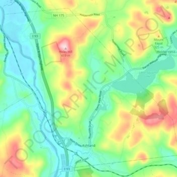
Name: Ashland topographic map, elevation, terrain.
Location: Ashland, Grafton County, New Hampshire, 03217, United States (43.68621 -71.67801 43.74946 -71.58207)
Average elevation: 231 m
Minimum elevation: 136 m
Maximum elevation: 417 m
Other topographic maps
Click on a map to view its topography, its elevation and its terrain.
Warren
United States > New Hampshire > Grafton County
From 1909 until 1970, Glencliff, located in the northern part of Warren, was the mailing address for the New Hampshire State Sanatorium, located just over the town line in Benton, at an elevation of 1,650 feet (500 m) on the slopes of Mount Moosilauke. Before the discovery of antibiotics, pure mountain air was…
Average elevation: 475 m
Stinson Lake
United States > New Hampshire > Grafton County > Rumney > Stinson Lake
Average elevation: 460 m
Holderness
United States > New Hampshire > Grafton County
According to the United States Census Bureau, the town has a total area of 35.7 square miles (92.5 km2), of which 30.3 square miles (78.6 km2) are land and 5.4 square miles (13.9 km2) are water, comprising 15.05% of the town.[1] Bounded on the northwest by the Pemigewasset River, Holderness is drained by Owl…
Average elevation: 252 m
Bristol
United States > New Hampshire > Grafton County
According to the United States Census Bureau, the town has a total area of 21.9 square miles (56.8 km2), of which 16.8 square miles (43.4 km2) are land and 5.2 square miles (13.4 km2) are water, comprising 23.60% of the town. Bristol is drained by the Pemigewasset River (forming the southeastern boundary of…
Average elevation: 254 m
Mount Kineo, East Peak
United States > New Hampshire > Grafton County > Ellsworth
Average elevation: 710 m
Enfield
United States > New Hampshire > Grafton County
According to the United States Census Bureau, the town has a total area of 43.1 square miles (111.6 km2), of which 40.3 sq mi (104.3 km2) is land and 2.9 sq mi (7.4 km2) is water, comprising 6.59% of the town. Enfield is drained by the Mascoma River. Mascoma Lake, in the west, represents Enfield's lowest…
Average elevation: 366 m
North Littleton
United States > New Hampshire > Grafton County > Littleton > North Littleton
Average elevation: 333 m
West Lebanon
United States > New Hampshire > Grafton County > Lebanon > West Lebanon
Average elevation: 165 m
LeBruns Mobile Home Park
United States > New Hampshire > Grafton County > Lebanon > LeBruns Mobile Home Park
Average elevation: 326 m
Bethlehem
United States > New Hampshire > Grafton County
According to the United States Census Bureau, the town has a total area of 91.0 square miles (235.6 km2), of which 90.6 square miles (234.7 km2) are land and 0.3 square miles (0.9 km2) are water, comprising 0.39% of the town. Bethlehem is drained by the Ammonoosuc, Gale, Zealand and Little rivers, together…
Average elevation: 528 m
Lincoln
United States > New Hampshire > Grafton County
Lincoln is drained by the Pemigewasset River and its East Branch. Lincoln lies almost fully within the Merrimack River watershed, with the western edge of town in the Connecticut River watershed. Kancamagus Pass, elevation 2,860 feet (870 m), is on the Kancamagus Highway at the eastern boundary. The highest…
Average elevation: 677 m