
Marmaris National Park topographic map
Interactive map
Click on the map to display elevation.
About this map
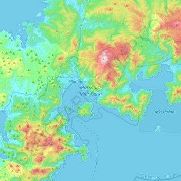
Name: Marmaris National Park topographic map, elevation, terrain.
Location: Marmaris National Park, Muğla, Aegean Region, Turkey (36.74514 28.19452 36.92849 28.56278)
Average elevation: 179 m
Minimum elevation: -1 m
Maximum elevation: 997 m
Other topographic maps
Click on a map to view its topography, its elevation and its terrain.
Cappadocia
Turkey > Central Anatolia Region > Göreme
The area was featured in several films due to its topography. The 1983 Italian/French/Turkish film Yor, the Hunter from the Future was filmed in Cappadocia. The region was used for the 1989 science fiction film Slipstream to depict a cult of wind worshippers. In 2010 and early 2011, the film Ghost Rider:…
Average elevation: 1,144 m