
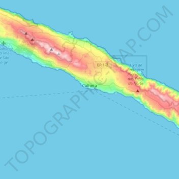
Calheta topographic map
Interactive map
Click on the map to display elevation.
About this map
Name: Calheta topographic map, elevation, terrain.
Location: Calheta, Azores, Portugal (38.53338 -28.06413 38.66638 -27.74363)
Average elevation: 101 m
Minimum elevation: 0 m
Maximum elevation: 1,034 m
Other topographic maps
Click on a map to view its topography, its elevation and its terrain.
Santo António da Serra
The parish of Santo António da Serra, located in the interior of the southern coast of Madeira, pertains to the municipality of Machico, confronted in the north and east by the parish of Porto da Cruz, west by the municipality of Santa Cruz, and by extent 20 kilometres from Funchal, the regional capital. It…
Average elevation: 624 m
Parque do Bonito
Portugal > Santarém > Entroncamento > Nossa Senhora de Fátima
Average elevation: 50 m
Soutelinho do Monte
Portugal > Vila Real > Vila Pouca de Aguiar > Vreia de Bornes
Average elevation: 577 m
Mount Pico
Mount Pico (Portuguese: Montanha do Pico) is a currently dormant stratovolcano located on Pico Island, in the mid-Atlantic archipelago of the Azores. It is the highest mountain in Portugal, at 2,351 metres (7,713 ft) above sea level, and is one of the highest Atlantic mountains; it is more than twice the…
Average elevation: 1,694 m
Cidadelha de Jales
Portugal > Vila Real > Vila Pouca de Aguiar > Alfarela de Jales
Average elevation: 783 m