
Bakewell CP topographic map
Click on the map to display elevation.
Bakewell CP
The Manchester, Buxton, Matlock and Midlands Junction Railway opened Bakewell railway station in 1862, then became part of the Midland Railway and later of the LMS main line from London to Manchester. John Ruskin objected to what he saw as desecration of the Derbyshire countryside and to the fact that "a Buxton fool may be able to find himself in Bakewell in twelve minutes and vice versa." In return for the Duke of Rutland's permission for the line to pass through his estate at Haddon Hall, Bakewell station buildings on the hillside overlooking the town are more imposing than expected and the Duke's coat of arms is carved in the stonework. Such pandering to landowners was common at the time, as their support was needed to pass the Act of Parliament allowing the line to be built. However, the inconvenient altitude of the line forced Bakewell station to be placed out of town, as the Duke insisted it be out of sight of Haddon Hall. These buildings are now used by small businesses, as the line between Matlock and Buxton was closed in 1968. Most of it has been designated the Monsal Trail, a bridle path for walking, cycling and riding.
About this map
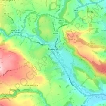
Name: Bakewell CP topographic map, elevation, terrain.
Average elevation: 194 m
Minimum elevation: 103 m
Maximum elevation: 353 m
Derbyshire trails, hiking, mountain biking, running and outdoor activities
Other topographic maps
Click on a map to view its topography, its elevation and its terrain.
Black Rocks
United Kingdom > England > Derbyshire > Derbyshire Dales > Cromford CP
Average elevation: 199 m
Hallam Moors
United Kingdom > England > Derbyshire > Derbyshire Dales > Hathersage
Average elevation: 368 m
Slaley
United Kingdom > England > Derbyshire > Derbyshire Dales > Matlock > Bonsall CP
Average elevation: 263 m
Bolehill
United Kingdom > England > Derbyshire > Derbyshire Dales > Wirksworth CP
Average elevation: 220 m
Riber Castle
United Kingdom > England > Derbyshire > Derbyshire Dales > Matlock > Starkholmes
Average elevation: 169 m
Monsal Head
United Kingdom > England > Derbyshire > Derbyshire Dales > Cressbrook > Monsal Head
Average elevation: 231 m
Parsley Hay
United Kingdom > England > Derbyshire > Derbyshire Dales > Parsley Hay
Average elevation: 334 m
Arbor Low
United Kingdom > England > Derbyshire > Derbyshire Dales > Parsley Hay
Average elevation: 342 m
Two Dales
United Kingdom > England > Derbyshire > Derbyshire Dales > Darley Dale CP > Darley Hillside
Average elevation: 189 m
Starkholmes
United Kingdom > England > Derbyshire > Derbyshire Dales > Matlock
Average elevation: 175 m
Farley Wood
United Kingdom > England > Derbyshire > Derbyshire Dales > Matlock
Average elevation: 255 m
Magpie Mine
United Kingdom > England > Derbyshire > Derbyshire Dales > Ashford in the Water CP
Average elevation: 303 m
Catcliff Wood
United Kingdom > England > Derbyshire > Derbyshire Dales > Bakewell CP
Average elevation: 173 m
Gang Mine
United Kingdom > England > Derbyshire > Derbyshire Dales > Cromford CP
Average elevation: 226 m
Taddington Dale
United Kingdom > England > Derbyshire > Derbyshire Dales > Brushfield CP
Average elevation: 281 m
Cressbrook Dale
United Kingdom > England > Derbyshire > Derbyshire Dales > Litton CP > Litton Mill
Average elevation: 286 m
Curbar Edge
United Kingdom > England > Derbyshire > Derbyshire Dales > Curbar CP
Average elevation: 252 m
Hathersage Booths
United Kingdom > England > Derbyshire > Derbyshire Dales > Hathersage
Average elevation: 260 m
Stanage Plantation
United Kingdom > England > Derbyshire > Derbyshire Dales > Hathersage
Average elevation: 360 m
Padley Gorge
United Kingdom > England > Derbyshire > Derbyshire Dales > Grindleford
Average elevation: 316 m
Horseshoe Quarry
United Kingdom > England > Derbyshire > Derbyshire Dales > Eyam CP
Average elevation: 293 m
Curbar Edge
United Kingdom > England > Derbyshire > Derbyshire Dales > Calver Sough
Average elevation: 251 m
Calver Sough
United Kingdom > England > Derbyshire > Derbyshire Dales > Calver Sough
Average elevation: 218 m
Breamfield
United Kingdom > England > Derbyshire > Derbyshire Dales > Wirksworth CP > Breamfield
Average elevation: 213 m
Coplow Dale
United Kingdom > England > Derbyshire > Derbyshire Dales > Little Hucklow
Average elevation: 333 m
Stoke Brook
United Kingdom > England > Derbyshire > Derbyshire Dales > Calver Sough
Average elevation: 197 m
Longstone Edge
United Kingdom > England > Derbyshire > Derbyshire Dales > Rowland
Average elevation: 290 m
Longcliffe
United Kingdom > England > Derbyshire > Derbyshire Dales > Brassington CP
Average elevation: 299 m
Lathkill Dale
United Kingdom > England > Derbyshire > Derbyshire Dales > Youlgreave
Average elevation: 269 m
Yarncliff Wood
United Kingdom > England > Derbyshire > Derbyshire Dales > Grindleford
Average elevation: 260 m
Breamfield
United Kingdom > England > Derbyshire > Derbyshire Dales > Wirksworth CP
Average elevation: 213 m
Padley Gorge
United Kingdom > England > Derbyshire > Derbyshire Dales > Grindleford
Average elevation: 316 m
Wirksworth Moor
United Kingdom > England > Derbyshire > Derbyshire Dales > Wirksworth CP
Average elevation: 207 m