
Make a donation
Gear up for your next adventure:
As an Amazon Associate, this site earns from qualifying purchases at no extra cost to you.
Italy topographic map
Click on the map to display elevation.
Make a donation
Gear up for your next adventure:
As an Amazon Associate, this site earns from qualifying purchases at no extra cost to you.
About this map
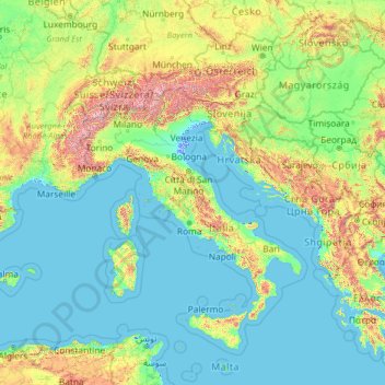
Name: Italy topographic map, elevation, terrain.
Location: Italy (35.13843 5.17430 50.13843 20.17430)
Average elevation: 335 m
Minimum elevation: -5 m
Maximum elevation: 4,188 m
Make a donation
Gear up for your next adventure:
As an Amazon Associate, this site earns from qualifying purchases at no extra cost to you.
Other topographic maps
Click on a map to view its topography, its elevation and its terrain.
Sardinia
The climate of the island is variable from area to area, due to several factors including the extension in latitude and the elevation. It can be classified in two different macrobioclimates (Mediterranean pluviseasonal oceanic and Temperate oceanic), one macrobioclimatic variant, called Submediterranean, and…
Average elevation: 115 m
Lake Como
Lake Como weather is humid subtropical (Cfa in the Köppen climate classification). In winter, the lake helps to maintain a higher temperature in the surrounding region. Average daily temperatures range from ~3.7 °C (39 °F) in January to 23.4 °C (74 °F) in July, according to historical weather data from…
Average elevation: 885 m
Make a donation
Gear up for your next adventure:
As an Amazon Associate, this site earns from qualifying purchases at no extra cost to you.
Alps
The altitude and size of the range affects the climate in Europe; in the mountains precipitation levels vary greatly and climatic conditions consist of distinct zones. Wildlife such as ibex live in the higher peaks to elevations of 3,400 m (11,155 ft), and plants such as Edelweiss grow in rocky areas in lower…
Average elevation: 1,284 m
Lake Garda
The particularly mild climate favours the growth of some hardy Mediterranean plants, including the olive tree, parasol pine, mediterranean cypress, chinese windmill palm and Canary Island Date Palm. Some hardy citrus trees, such as hardy lemons and satsuma can also be found, which are extremely rare at this…
Average elevation: 571 m
Lake Maggiore
Italy > Piedmont > Verbano-Cusio-Ossola
Lake Maggiore weather is humid subtropical (Cfa in the Köppen climate classification). During winter, the lake helps to maintain a higher temperature in the surrounding region (since water releases heat energy more slowly than air). The temperatures are cooled down in summer by the breezes that blow on the…
Average elevation: 655 m
Make a donation
Gear up for your next adventure:
As an Amazon Associate, this site earns from qualifying purchases at no extra cost to you.
Matera
Italy > Basilicata > Matera
The Sassi consist of around twelve levels spanning the height of 380 m, connected by a network of paths, stairways, and courtyards (vicinati). The medieval city clinging on to the edge of the canyon for its defence is invisible from the western approach. The tripartite urban structure of Civita and the two…
Average elevation: 293 m
Make a donation
Gear up for your next adventure:
As an Amazon Associate, this site earns from qualifying purchases at no extra cost to you.
Eppan an der Weinstraße - Appiano sulla Strada del Vino
Italy > Trentino – Alto Adige/Südtirol > South Tyrol
Average elevation: 701 m
Make a donation
Gear up for your next adventure:
As an Amazon Associate, this site earns from qualifying purchases at no extra cost to you.
Castel del Monte
Castel del Monte is situated on a small hill close to the monastery of Santa Maria del Monte, at an altitude of 540 metres (1,770 ft). When the castle was built, the region was famously fertile with a plentiful supply of water and lush vegetation. It lies in the comune of Andria, province of…
Average elevation: 453 m
Make a donation
Gear up for your next adventure:
As an Amazon Associate, this site earns from qualifying purchases at no extra cost to you.
Seiser Alm-Gruppe - Gruppo Mont de Sëuc - Gruppo dell'Alpe di Siusi
Italy > Trentino – Alto Adige/Südtirol > South Tyrol > Kastelruth - Castelrotto
Seiser Alm (Italian: Alpe di Siusi, Ladin: Mont Sëuc) is a Dolomite plateau and the largest high-elevation Alpine meadow (German: Alm) in Europe. Located in Italy's South Tyrol province in the Dolomites mountain range, it is a major tourist attraction, notably for skiing and hiking.
Average elevation: 1,466 m
Albeins - Albes
Italy > Trentino – Alto Adige/Südtirol > South Tyrol > Brixen - Bressanone
Average elevation: 729 m
Make a donation
Gear up for your next adventure:
As an Amazon Associate, this site earns from qualifying purchases at no extra cost to you.
Make a donation
Gear up for your next adventure:
As an Amazon Associate, this site earns from qualifying purchases at no extra cost to you.
Corleone
Along the road that connects Corleone with Ficuzza, following the old railway line connecting Palermo to San Carlo (a hamlet of Chiusa Sclafani) (now the bike path), is an old bridge where the Frattina River streams between the limestone rocks. The erosive action of water has produced karst topography over…
Average elevation: 625 m
Make a donation
Gear up for your next adventure:
As an Amazon Associate, this site earns from qualifying purchases at no extra cost to you.
Make a donation
Gear up for your next adventure:
As an Amazon Associate, this site earns from qualifying purchases at no extra cost to you.
Make a donation
Gear up for your next adventure:
As an Amazon Associate, this site earns from qualifying purchases at no extra cost to you.
Make a donation
Gear up for your next adventure:
As an Amazon Associate, this site earns from qualifying purchases at no extra cost to you.
Make a donation
Gear up for your next adventure:
As an Amazon Associate, this site earns from qualifying purchases at no extra cost to you.
Make a donation
Gear up for your next adventure:
As an Amazon Associate, this site earns from qualifying purchases at no extra cost to you.
Make a donation
Gear up for your next adventure:
As an Amazon Associate, this site earns from qualifying purchases at no extra cost to you.
Make a donation
Gear up for your next adventure:
As an Amazon Associate, this site earns from qualifying purchases at no extra cost to you.
Dolina Seghina / Šeginov Dol
Italy > Friuli-Venezia Giulia > Trieste > Gabrovizza / Gabrovec > Stazione di Prosecco / Proseška Postaja
Average elevation: 249 m
Make a donation
Gear up for your next adventure:
As an Amazon Associate, this site earns from qualifying purchases at no extra cost to you.
Make a donation
Gear up for your next adventure:
As an Amazon Associate, this site earns from qualifying purchases at no extra cost to you.
Make a donation
Gear up for your next adventure:
As an Amazon Associate, this site earns from qualifying purchases at no extra cost to you.
Roccasecca
The history of Roccasecca is tightly bound to its strategic position, a "dry rocca" at the entrance to two narrow defiles that give access to the Valle di Comino below the slopes of Monte Asprano, whose elevation at 553 metres (1,814 ft) provides a natural position to control the wide Valle del Liri. Remains…
Average elevation: 327 m
Make a donation
Gear up for your next adventure:
As an Amazon Associate, this site earns from qualifying purchases at no extra cost to you.
Castello Tesino
Italy > Trentino – Alto Adige/Südtirol > Provincia di Trento
Average elevation: 1,350 m
Make a donation
Gear up for your next adventure:
As an Amazon Associate, this site earns from qualifying purchases at no extra cost to you.
Make a donation
Gear up for your next adventure:
As an Amazon Associate, this site earns from qualifying purchases at no extra cost to you.
Guardiagrele
Guardiagrele (Italian pronunciation: [ɡuardiaˈɡreːle]; Abruzzese: La 'Uàrdije; Latin: Guardia Graelis) is a town and comune in the province of Chieti, part of the Abruzzo region of central Italy. It is in the foothills of the Maiella mountain at an elevation of around 576 metres (1,890 ft). Its population…
Average elevation: 534 m
Make a donation
Gear up for your next adventure:
As an Amazon Associate, this site earns from qualifying purchases at no extra cost to you.
Make a donation
Gear up for your next adventure:
As an Amazon Associate, this site earns from qualifying purchases at no extra cost to you.
Make a donation
Gear up for your next adventure:
As an Amazon Associate, this site earns from qualifying purchases at no extra cost to you.
Riserva naturale orientata Sughereta di Niscemi
Italy > Sicily > Catania > Caltagirone
Average elevation: 176 m
Make a donation
Gear up for your next adventure:
As an Amazon Associate, this site earns from qualifying purchases at no extra cost to you.