
Make a donation
Gear up for your next adventure:
As an Amazon Associate, this site earns from qualifying purchases at no extra cost to you.
Hulland Ward CP topographic map
Click on the map to display elevation.
Make a donation
Gear up for your next adventure:
As an Amazon Associate, this site earns from qualifying purchases at no extra cost to you.
About this map
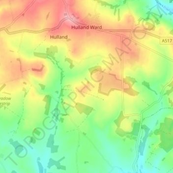
Name: Hulland Ward CP topographic map, elevation, terrain.
Average elevation: 169 m
Minimum elevation: 112 m
Maximum elevation: 239 m
Derbyshire trails, hiking, mountain biking, running and outdoor activities
Make a donation
Gear up for your next adventure:
As an Amazon Associate, this site earns from qualifying purchases at no extra cost to you.
Other topographic maps
Click on a map to view its topography, its elevation and its terrain.
Hallam Moors
United Kingdom > England > Derbyshire > Derbyshire Dales > Hathersage
Average elevation: 368 m
Slaley
United Kingdom > England > Derbyshire > Derbyshire Dales > Matlock > Bonsall CP
Average elevation: 263 m
Make a donation
Gear up for your next adventure:
As an Amazon Associate, this site earns from qualifying purchases at no extra cost to you.
Bolehill
United Kingdom > England > Derbyshire > Derbyshire Dales > Wirksworth CP
Average elevation: 220 m
Make a donation
Gear up for your next adventure:
As an Amazon Associate, this site earns from qualifying purchases at no extra cost to you.
Two Dales
United Kingdom > England > Derbyshire > Derbyshire Dales > Darley Dale CP > Darley Hillside
Average elevation: 189 m
Make a donation
Gear up for your next adventure:
As an Amazon Associate, this site earns from qualifying purchases at no extra cost to you.
Starkholmes
United Kingdom > England > Derbyshire > Derbyshire Dales > Matlock
Average elevation: 175 m
Farley Wood
United Kingdom > England > Derbyshire > Derbyshire Dales > Matlock
Average elevation: 255 m
Magpie Mine
United Kingdom > England > Derbyshire > Derbyshire Dales > Ashford in the Water CP
Average elevation: 303 m
Make a donation
Gear up for your next adventure:
As an Amazon Associate, this site earns from qualifying purchases at no extra cost to you.
Catcliff Wood
United Kingdom > England > Derbyshire > Derbyshire Dales > Bakewell CP
Average elevation: 173 m
Make a donation
Gear up for your next adventure:
As an Amazon Associate, this site earns from qualifying purchases at no extra cost to you.
Gang Mine
United Kingdom > England > Derbyshire > Derbyshire Dales > Cromford CP
Average elevation: 226 m
Taddington Dale
United Kingdom > England > Derbyshire > Derbyshire Dales > Brushfield CP
Average elevation: 281 m
Cressbrook Dale
United Kingdom > England > Derbyshire > Derbyshire Dales > Litton CP > Litton Mill
Average elevation: 286 m
Make a donation
Gear up for your next adventure:
As an Amazon Associate, this site earns from qualifying purchases at no extra cost to you.
Curbar Edge
United Kingdom > England > Derbyshire > Derbyshire Dales > Curbar CP
Average elevation: 252 m
Hathersage Booths
United Kingdom > England > Derbyshire > Derbyshire Dales > Hathersage
Average elevation: 260 m
Make a donation
Gear up for your next adventure:
As an Amazon Associate, this site earns from qualifying purchases at no extra cost to you.
Stanage Plantation
United Kingdom > England > Derbyshire > Derbyshire Dales > Hathersage
Average elevation: 360 m
Make a donation
Gear up for your next adventure:
As an Amazon Associate, this site earns from qualifying purchases at no extra cost to you.
Black Rocks
United Kingdom > England > Derbyshire > Derbyshire Dales > Cromford CP
Average elevation: 199 m
Make a donation
Gear up for your next adventure:
As an Amazon Associate, this site earns from qualifying purchases at no extra cost to you.
Padley Gorge
United Kingdom > England > Derbyshire > Derbyshire Dales > Grindleford
Average elevation: 316 m
Curbar Edge
United Kingdom > England > Derbyshire > Derbyshire Dales > Calver Sough
Average elevation: 251 m
Riber Castle
United Kingdom > England > Derbyshire > Derbyshire Dales > Matlock > Starkholmes
Average elevation: 169 m
Make a donation
Gear up for your next adventure:
As an Amazon Associate, this site earns from qualifying purchases at no extra cost to you.
Monsal Head
United Kingdom > England > Derbyshire > Derbyshire Dales > Cressbrook > Monsal Head
Average elevation: 231 m
Breamfield
United Kingdom > England > Derbyshire > Derbyshire Dales > Wirksworth CP > Breamfield
Average elevation: 213 m
Make a donation
Gear up for your next adventure:
As an Amazon Associate, this site earns from qualifying purchases at no extra cost to you.
Coplow Dale
United Kingdom > England > Derbyshire > Derbyshire Dales > Little Hucklow
Average elevation: 333 m
Stoke Brook
United Kingdom > England > Derbyshire > Derbyshire Dales > Calver Sough
Average elevation: 197 m
Yarncliff Wood
United Kingdom > England > Derbyshire > Derbyshire Dales > Grindleford
Average elevation: 260 m
Make a donation
Gear up for your next adventure:
As an Amazon Associate, this site earns from qualifying purchases at no extra cost to you.
Calver Sough
United Kingdom > England > Derbyshire > Derbyshire Dales > Calver Sough
Average elevation: 218 m
Parsley Hay
United Kingdom > England > Derbyshire > Derbyshire Dales > Parsley Hay
Average elevation: 334 m
Longstone Edge
United Kingdom > England > Derbyshire > Derbyshire Dales > Rowland
Average elevation: 290 m
Make a donation
Gear up for your next adventure:
As an Amazon Associate, this site earns from qualifying purchases at no extra cost to you.
Arbor Low
United Kingdom > England > Derbyshire > Derbyshire Dales > Parsley Hay
Average elevation: 342 m
Longcliffe
United Kingdom > England > Derbyshire > Derbyshire Dales > Brassington CP
Average elevation: 299 m
Lathkill Dale
United Kingdom > England > Derbyshire > Derbyshire Dales > Youlgreave
Average elevation: 269 m
Make a donation
Gear up for your next adventure:
As an Amazon Associate, this site earns from qualifying purchases at no extra cost to you.
Breamfield
United Kingdom > England > Derbyshire > Derbyshire Dales > Wirksworth CP
Average elevation: 213 m
Wirksworth Moor
United Kingdom > England > Derbyshire > Derbyshire Dales > Wirksworth CP
Average elevation: 207 m
Make a donation
Gear up for your next adventure:
As an Amazon Associate, this site earns from qualifying purchases at no extra cost to you.
Padley Gorge
United Kingdom > England > Derbyshire > Derbyshire Dales > Grindleford
Average elevation: 316 m
Make a donation
Gear up for your next adventure:
As an Amazon Associate, this site earns from qualifying purchases at no extra cost to you.