
Make a donation
Gear up for your next adventure:
As an Amazon Associate, this site earns from qualifying purchases at no extra cost to you.
Kadar topographic map
Click on the map to display elevation.
Make a donation
Gear up for your next adventure:
As an Amazon Associate, this site earns from qualifying purchases at no extra cost to you.
About this map
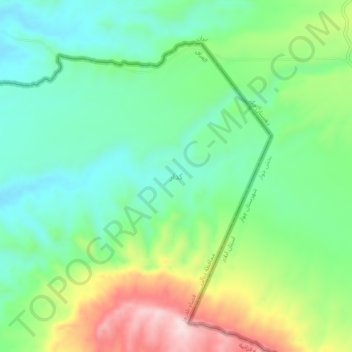
Name: Kadar topographic map, elevation, terrain.
Location: Kadar, Qazaniyah Subdistrict, Balad Ruz District, Iraq (33.60303 45.88363 33.64303 45.92363)
Average elevation: 429 m
Minimum elevation: 314 m
Maximum elevation: 658 m
Make a donation
Gear up for your next adventure:
As an Amazon Associate, this site earns from qualifying purchases at no extra cost to you.
Other topographic maps
Click on a map to view its topography, its elevation and its terrain.
Make a donation
Gear up for your next adventure:
As an Amazon Associate, this site earns from qualifying purchases at no extra cost to you.
Make a donation
Gear up for your next adventure:
As an Amazon Associate, this site earns from qualifying purchases at no extra cost to you.
Al-Anbar Governorate
Anbar is one of the driest governorates in Iraq's western desert climate. Some of Al Anbar is part of the Syrian Desert, characterized by steppe and desert terrain. Most of Al Anbar is considered as a topographical continuation of the Arabian Peninsula plateau region. It has some small hills and a number of…
Average elevation: 399 m
Darbandikhan Dam
Iraq > Sulaymaniyah Governorate > Darbandikhan
The dam is located within a gorge on a foundation of sedimentary rocks. It is a rock-fill embankment type with a central clay core. The dam is 128 m (420 ft) tall and 445 m (1,460 ft) long (535 m (1,755 ft) if the spillway section is included). Its crest is 17 m (56 ft) wide and at an elevation of 495 m (1,624…
Average elevation: 571 m
Make a donation
Gear up for your next adventure:
As an Amazon Associate, this site earns from qualifying purchases at no extra cost to you.
Make a donation
Gear up for your next adventure:
As an Amazon Associate, this site earns from qualifying purchases at no extra cost to you.
Babylon
Iraq > Babil Governorate > Qaryat Annan
A topographical survey at the site was conducted in 1974, followed in 1977 by a review of the stratigraphical position of the main monuments and reconsideration of ancient water levels, by the Turin Centre for Archaeological Research and Excavations in the Middle East and Asia, and the Iraqi-Italian Institute…
Average elevation: 32 m
Umm al Binni lake
Based on the interpretation of satellite imagery, Sharad Master suggests the 3.4 km (2.1 mi) in diameter dry lake may be an impact crater based on its nearly circular, slightly polygonal rim shape, and contrasting shape to other lakes in the region. However, the circularity of its shape has been disputed, with…
Average elevation: 2 m
Make a donation
Gear up for your next adventure:
As an Amazon Associate, this site earns from qualifying purchases at no extra cost to you.
Al-Anbar Governorate
Anbar is one of the driest governorates in Iraq's western desert climate. Some of Al Anbar is part of the Syrian Desert, characterized by steppe and desert terrain. Most of Al Anbar is considered as a topographical continuation of the Arabian Peninsula plateau region. It has some small hills and a number of…
Average elevation: 399 m
Make a donation
Gear up for your next adventure:
As an Amazon Associate, this site earns from qualifying purchases at no extra cost to you.
Darbandikhan Dam
The dam is located within a gorge on a foundation of sedimentary rocks. It is a rock-fill embankment type with a central clay core. The dam is 128 m (420 ft) tall and 445 m (1,460 ft) long (535 m (1,755 ft) if the spillway section is included). Its crest is 17 m (56 ft) wide and at an elevation of 495 m (1,624…
Average elevation: 571 m
Make a donation
Gear up for your next adventure:
As an Amazon Associate, this site earns from qualifying purchases at no extra cost to you.
Al-Anbar Governorate
Anbar is one of the driest governorates in Iraq's western desert climate. Some of Al Anbar is part of the Syrian Desert, characterized by steppe and desert terrain. Most of Al Anbar is considered as a topographical continuation of the Arabian Peninsula plateau region. It has some small hills and a number of…
Average elevation: 399 m
Make a donation
Gear up for your next adventure:
As an Amazon Associate, this site earns from qualifying purchases at no extra cost to you.
Make a donation
Gear up for your next adventure:
As an Amazon Associate, this site earns from qualifying purchases at no extra cost to you.
Make a donation
Gear up for your next adventure:
As an Amazon Associate, this site earns from qualifying purchases at no extra cost to you.
Make a donation
Gear up for your next adventure:
As an Amazon Associate, this site earns from qualifying purchases at no extra cost to you.
Make a donation
Gear up for your next adventure:
As an Amazon Associate, this site earns from qualifying purchases at no extra cost to you.
Make a donation
Gear up for your next adventure:
As an Amazon Associate, this site earns from qualifying purchases at no extra cost to you.
Make a donation
Gear up for your next adventure:
As an Amazon Associate, this site earns from qualifying purchases at no extra cost to you.
Make a donation
Gear up for your next adventure:
As an Amazon Associate, this site earns from qualifying purchases at no extra cost to you.
Make a donation
Gear up for your next adventure:
As an Amazon Associate, this site earns from qualifying purchases at no extra cost to you.
Make a donation
Gear up for your next adventure:
As an Amazon Associate, this site earns from qualifying purchases at no extra cost to you.
Make a donation
Gear up for your next adventure:
As an Amazon Associate, this site earns from qualifying purchases at no extra cost to you.
Make a donation
Gear up for your next adventure:
As an Amazon Associate, this site earns from qualifying purchases at no extra cost to you.
Make a donation
Gear up for your next adventure:
As an Amazon Associate, this site earns from qualifying purchases at no extra cost to you.
Halabja Governorate
Halabja is located in the Shahrizor plain, a fertile valley nestled in the foothills of the Zagros Mountains in the Kurdistan Region of Iraq. The city's elevation is around 700 meters above sea level. The surrounding area is characterized by mountainous terrain, with the Hawraman Mountain range to the east,…
Average elevation: 1,055 m
Make a donation
Gear up for your next adventure:
As an Amazon Associate, this site earns from qualifying purchases at no extra cost to you.
Make a donation
Gear up for your next adventure:
As an Amazon Associate, this site earns from qualifying purchases at no extra cost to you.
Make a donation
Gear up for your next adventure:
As an Amazon Associate, this site earns from qualifying purchases at no extra cost to you.
Make a donation
Gear up for your next adventure:
As an Amazon Associate, this site earns from qualifying purchases at no extra cost to you.
Make a donation
Gear up for your next adventure:
As an Amazon Associate, this site earns from qualifying purchases at no extra cost to you.