
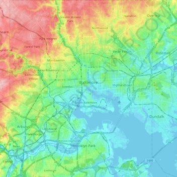
Baltimore topographic map
Interactive map
Click on the map to display elevation.
About this map
Name: Baltimore topographic map, elevation, terrain.
Location: Baltimore, Maryland, United States (39.19723 -76.71130 39.37200 -76.52968)
Average elevation: 47 m
Minimum elevation: -4 m
Maximum elevation: 158 m
Baltimore is in north-central Maryland on the Patapsco River close to where it empties into the Chesapeake Bay. The city is also located on the fall line between the Piedmont Plateau and the Atlantic coastal plain, which divides Baltimore into "lower city" and "upper city". The city's elevation ranges from sea level at the harbor to 480 feet (150 m) in the northwest corner near Pimlico.
Other topographic maps
Click on a map to view its topography, its elevation and its terrain.
Annapolis
United States > Maryland > Anne Arundel County
Annapolis, Anne Arundel County, Maryland, United States
Average elevation: 8 m
Baltimore
United States > Maryland > Baltimore
Baltimore, Maryland, 21233, United States
Average elevation: 65 m
Golts
United States > Maryland > Kent County
Golts, Kent County, Maryland, United States
Average elevation: 22 m
Middle East
United States > Maryland > Baltimore
Middle East, Baltimore, Maryland, United States
Average elevation: 29 m
Frederick County
Frederick County, Maryland, United States
Average elevation: 186 m
Prince George's County
Prince George's County, Maryland, United States
Average elevation: 45 m
Rockville
United States > Maryland > Montgomery County
Rockville, Montgomery County, Maryland, United States
Average elevation: 122 m
Ellicott City
United States > Maryland > Howard County
Ellicott City, Howard County, Maryland, 21043, United States
Average elevation: 119 m
Gambrills
United States > Maryland > Anne Arundel County > Gambrills
Gambrills, Anne Arundel County, Maryland, United States
Average elevation: 37 m
Carderock
United States > Maryland > Montgomery County > Potomac
Carderock, Potomac, Montgomery County, Maryland, 20818, United States
Average elevation: 58 m
Thurmont
United States > Maryland > Frederick County
Thurmont, Frederick County, Maryland, United States
Average elevation: 184 m
Patapsco Valley State Park
United States > Maryland > Howard County > Ilchester
Patapsco Valley State Park, Ilchester, Howard County, Maryland, 21163, United States
Average elevation: 131 m
Salisbury
United States > Maryland > Wicomico County
Salisbury, Wicomico County, Maryland, United States
Average elevation: 12 m
Old Colony
United States > Maryland > Charles County > La Plata
Old Colony, La Plata, Charles County, Maryland, 20646, United States
Average elevation: 52 m
Highfield Park
United States > Maryland > Harford County > Bel Air
Highfield Park, Bel Air, Harford County, Maryland, United States
Average elevation: 153 m
West Frederick Highlands
United States > Maryland > Frederick County > Ballenger Creek
West Frederick Highlands, Ballenger Creek, Frederick County, Maryland, 21703, United States
Average elevation: 113 m
Centennial Lake
United States > Maryland > Howard County
Centennial Lake, Dorsey's Search, Howard County, Maryland, United States
Average elevation: 116 m
Ridgely
United States > Maryland > Caroline County
Ridgely, Caroline County, Maryland, 21660, United States
Average elevation: 18 m
Gist
United States > Maryland > Carroll County
Gist, Carroll County, Maryland, United States
Average elevation: 203 m
Temple Hills
United States > Maryland > Prince George's County
Temple Hills, Prince George's County, Maryland, 20748, United States
Average elevation: 66 m
Colt Terrace Neighborhood Park
United States > Maryland > Montgomery County > Silver Spring
Colt Terrace Neighborhood Park, 11400, Silver Spring, Montgomery County, Maryland, 20902, United States
Average elevation: 119 m
Bel Air
United States > Maryland > Harford County
Bel Air, Harford County, Maryland, 21014, United States
Average elevation: 103 m
Cecil Manor
United States > Maryland > Cecil County
Cecil Manor, Cecil County, Maryland, 21920, United States
Average elevation: 44 m
Fox Field
United States > Maryland > Caroline County
Fox Field, Caroline County, Maryland, 21641, United States
Average elevation: 15 m
Queensberry
United States > Maryland > Calvert County > Prince Frederick
Queensberry, Prince Frederick, Calvert County, Maryland, 20678, United States
Average elevation: 37 m
Jersey Island
United States > Maryland > Somerset County > Crisfield
Jersey Island, Crisfield, Somerset County, Maryland, 21817, United States
Average elevation: 2 m
Calvert Cliffs
United States > Maryland > Calvert County
Calvert Cliffs, Calvert County, Maryland, 20657, United States
Average elevation: 11 m
Accident
United States > Maryland > Garrett County
Accident, Garrett County, Maryland, United States
Average elevation: 751 m
Cumberland
United States > Maryland > Allegany County
Cumberland, Allegany County, Maryland, 21502, United States
Average elevation: 264 m
Dundalk
United States > Maryland > Baltimore County
Dundalk, Baltimore County, Maryland, 21222, United States
Average elevation: 33 m
Lutherville
United States > Maryland > Baltimore County
Lutherville, Baltimore County, Maryland, 21204, United States
Average elevation: 117 m
Elkridge
United States > Maryland > Howard County
Elkridge, Howard County, Maryland, 21075, United States
Average elevation: 39 m
Severn
United States > Maryland > Anne Arundel County > Severn
Severn, Anne Arundel County, Maryland, United States
Average elevation: 47 m
Towson
United States > Maryland > Baltimore County
Towson, Baltimore County, Maryland, 21252, United States
Average elevation: 101 m
Heritage Valley
United States > Maryland > Cecil County > Elkton
Heritage Valley, Elkton, Cecil County, Maryland, 21922, United States
Average elevation: 15 m
Nottingham
United States > Maryland > Anne Arundel County
Nottingham, Anne Arundel County, Maryland, 21405, United States
Average elevation: 16 m
Severna Park
United States > Maryland > Anne Arundel County
Severna Park, Anne Arundel County, Maryland, 21146, United States
Average elevation: 14 m
Arnold
United States > Maryland > Anne Arundel County
Arnold, Anne Arundel County, Maryland, 21012, United States
Average elevation: 15 m
Lusby
United States > Maryland > Calvert County
Lusby, Calvert County, Maryland, United States
Average elevation: 26 m
Millersville
United States > Maryland > Anne Arundel County
Millersville, Anne Arundel County, Maryland, 21054, United States
Average elevation: 38 m
Riva
United States > Maryland > Anne Arundel County
Riva, Anne Arundel County, Maryland, 21041, United States
Average elevation: 11 m
Sturbridge
United States > Maryland > Anne Arundel County > Arnold
Sturbridge, Arnold, Anne Arundel County, Maryland, 22409, United States
Average elevation: 21 m
Ragged Island
United States > Maryland > Dorchester County
Ragged Island, Dorchester County, Maryland, United States
Average elevation: 0 m
Colesville Park
United States > Maryland > Montgomery County > Cloverly
Colesville Park, Cloverly, Montgomery County, Maryland, 20905, United States
Average elevation: 131 m
Pasadena
United States > Maryland > Anne Arundel County
Pasadena, Anne Arundel County, Maryland, 21122, United States
Average elevation: 16 m
Washington County
Washington County, Maryland, United States
Average elevation: 195 m
Parkville
United States > Maryland > Baltimore County
Parkville, Baltimore County, Maryland, 21234, United States
Average elevation: 91 m
Queen Anne's County
Queen Anne's County, Maryland, United States
Average elevation: 10 m
Wicomico County
Wicomico County, Maryland, United States
Average elevation: 9 m
Glen Burnie
United States > Maryland > Anne Arundel County
Glen Burnie, Anne Arundel County, Maryland, 21061, United States
Average elevation: 25 m