
Ankober topographic map
Interactive map
Click on the map to display elevation.
About this map
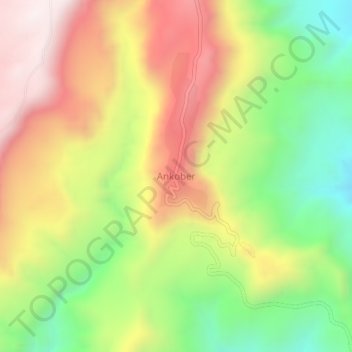
Name: Ankober topographic map, elevation, terrain.
Location: Ankober, North Shewa (Amhara Region), Amhara, Éthiopie (9.57115 39.71382 9.61115 39.75382)
Average elevation: 2,672 m
Minimum elevation: 2,185 m
Maximum elevation: 3,183 m
Ankober (également appelée Gorobela) est une ville d'Éthiopie, ancienne capitale du royaume de Shoa. Elle est située dans la zone de Semien Shewa de la région Amhara, elle se trouve à 40 kilomètres à l'est de Debre Berhan, à 2 465 mètres d'altitude.
Other topographic maps
Click on a map to view its topography, its elevation and its terrain.
Bahir Dar zone spéciale
Bahir Dar zone spéciale, Amhara, Éthiopie
Average elevation: 1,794 m
North Shewa (Amhara Region)
North Shewa (Amhara Region), Amhara, Éthiopie
Average elevation: 1,808 m