Geolocate

Washington County topographic map

Interactive map

Click on the map to display elevation.

Washington County

The economy of Washington County was based on apples in the late 19th century. A mixture of wet weather, altitude, and loamy soils provided a good environment for apple orchards. First planted in areas around Lincoln, Evansville, and Cane Hill in the 1830s, apple orchards began all across the county. The United States Census reported a crop of 614,924 bushels of apples produced by the county in 1900, the highest in the state. Several varieties of apple were discovered in the area including Shannon Pippin, Wilson June, and most notably the Arkansas Black. The Ben Davis became the apple of choice in the area for sale and shipment across the region. Corn became the dominant crop, outselling apples by almost $500,000 in 1900.

Wikipedia (CC-BY-SA 3.0)

About this map

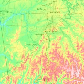
Name: Washington County topographic map, elevation, terrain.

Location: Washington County, Arkansas, United States (35.75031 -94.55217 36.23610 -93.88789)

Average elevation: 424 m

Minimum elevation: 267 m

Maximum elevation: 735 m

Other topographic maps

Click on a map to view its topography, its elevation and its terrain.

Barringer

United States > Arkansas > Clark County

Average elevation: 75 m

North Pole Knob

United States > Arkansas > Newton County

Average elevation: 412 m

Perkins

United States > Arkansas > Howard County

Average elevation: 160 m

Moscow

United States > Arkansas > Jefferson County

Average elevation: 58 m

Toad Suck

United States > Arkansas > Perry County

Average elevation: 93 m

Florence

United States > Arkansas > Drew County

Average elevation: 55 m

Mesa View

United States > Arkansas > Pulaski County > Little Rock

Average elevation: 141 m

Antioch

United States > Arkansas > Randolph County

Average elevation: 130 m

Springhill

United States > Arkansas > Saline County > Bryant

Average elevation: 136 m

Magazine Mountain

United States > Arkansas > Logan County

Mount Magazine is often called "the highest point between the Alleghenies and the Rockies" (there are mountains located in the Trans-Pecos region of far-west Texas which exceed Mount Magazine in elevation and prominence, although the Trans-Pecos region lies so far south of the Rockies, that region arguably…

Average elevation: 670 m

Whitaker Point

United States > Arkansas > Newton County

Average elevation: 571 m

Wolf Pinnacle

United States > Arkansas > Saline County

Average elevation: 297 m

Ryker

United States > Arkansas > Newton County

Average elevation: 641 m

Buffalo City

United States > Arkansas > Baxter County

Average elevation: 176 m

Petit Jean

United States > Arkansas > Yell County

Average elevation: 108 m

Pinnacle

United States > Arkansas > Washington County

Average elevation: 360 m

Petit Jean

United States > Arkansas > Yell County

Average elevation: 108 m

Moreland

United States > Arkansas > Pope County

Average elevation: 236 m

Brister

United States > Arkansas > Columbia County

Average elevation: 83 m

Glory Hole

United States > Arkansas > Newton County

Average elevation: 590 m

Canehill

United States > Arkansas > Washington County

Average elevation: 446 m

Witter

United States > Arkansas > Madison County

Average elevation: 494 m

Fox

United States > Arkansas > Stone County

Average elevation: 407 m

Crosses

United States > Arkansas > Madison County

Average elevation: 490 m

Briar

United States > Arkansas > Howard County

Average elevation: 152 m

Hensley

United States > Arkansas > Pulaski County > Hensley

Average elevation: 75 m

Sonora

United States > Arkansas > Washington County

Average elevation: 388 m

River Mountain

United States > Arkansas > Logan County

Average elevation: 257 m

Kirby

United States > Arkansas > Pike County

Average elevation: 198 m

Ben Hur

United States > Arkansas > Newton County

Average elevation: 501 m

Sills

United States > Arkansas > Yell County

Average elevation: 128 m

Forum

United States > Arkansas > Madison County

Average elevation: 454 m

Durham

United States > Arkansas > Washington County

Average elevation: 411 m

Wayton

United States > Arkansas > Newton County

Average elevation: 561 m

Bass

United States > Arkansas > Newton County

Average elevation: 322 m

Strickler

United States > Arkansas > Washington County

Average elevation: 486 m

Greenfield

United States > Arkansas > Poinsett County

Average elevation: 87 m

Columbus

United States > Arkansas > Hempstead County

Average elevation: 123 m

Cord

United States > Arkansas > Independence County

Average elevation: 93 m

Price Place

United States > Arkansas > Marion County

Average elevation: 219 m

Patrick

United States > Arkansas > Madison County

Average elevation: 479 m

Ponca

United States > Arkansas > Newton County

Average elevation: 443 m

Pettigrew

United States > Arkansas > Madison County

Average elevation: 632 m

Peppers Lake

United States > Arkansas > Prairie County

Average elevation: 64 m

Alma

United States > Arkansas > Crawford County

Average elevation: 167 m

Hagarville

United States > Arkansas > Johnson County

Average elevation: 173 m

Delmar

United States > Arkansas > Carroll County

Average elevation: 535 m

Carryville

United States > Arkansas > Clay County

Average elevation: 83 m

Kimberley

United States > Arkansas > Pike County > Murfreesboro

Average elevation: 106 m

Gavin

United States > Arkansas > Crittenden County > Marion

Average elevation: 67 m

Avilla

United States > Arkansas > Saline County

Average elevation: 154 m

Hogeye

United States > Arkansas > Washington County

Average elevation: 414 m

De Queen Dam

United States > Arkansas > Sevier County

Average elevation: 144 m

Monte Ne Shores

United States > Arkansas > Benton County

Average elevation: 380 m

Shady Grove

United States > Arkansas > Baxter County

Average elevation: 214 m

Fouke

United States > Arkansas > Miller County

Average elevation: 86 m

Mount Nebo

United States > Arkansas > Yell County

Average elevation: 351 m

Lono

United States > Arkansas > Hot Spring County

Average elevation: 141 m

Joplin

United States > Arkansas > Montgomery County

Average elevation: 231 m

Tulip

United States > Arkansas > Dallas County

Average elevation: 132 m

Natural Dam

United States > Arkansas > Crawford County

Average elevation: 246 m

Erbie

United States > Arkansas > Newton County

Average elevation: 361 m

Jones Mills

United States > Arkansas > Hot Spring County

Average elevation: 120 m

Smyrna

United States > Arkansas > Pope County

Average elevation: 402 m

Pruitt

United States > Arkansas > Newton County

Average elevation: 300 m

Center Ridge

United States > Arkansas > Conway County

Average elevation: 211 m

Scotland

United States > Arkansas > Van Buren County

Average elevation: 242 m

Bill Hill

United States > Arkansas > Independence County

Average elevation: 127 m

Indian

United States > Arkansas > Chicot County

Average elevation: 38 m