
Tripura topographic map
Interactive map
Click on the map to display elevation.
About this map
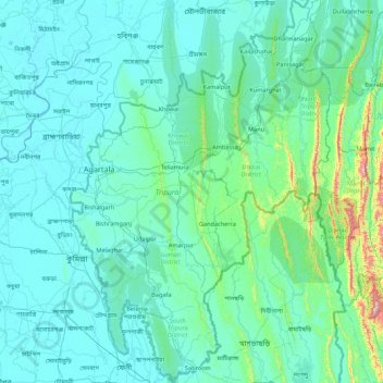
Name: Tripura topographic map, elevation, terrain.
Location: Tripura, India (22.93761 91.15081 24.53088 92.33585)
Average elevation: 85 m
Minimum elevation: 0 m
Maximum elevation: 1,320 m
The physiography is characterised by hill ranges, valleys and plains. The state has five anticlinal ranges of hills running north to south, from Boromura in the west, through Atharamura, Longtharai and Shakhan, to the Jampui Hills in the east. The intervening synclines are the Agartala–Udaipur, Khowai–Teliamura, Kamalpur–Ambasa, Kailasahar–Manu and Dharmanagar–Kanchanpur valleys. At an altitude of 939 m (3,081 ft), Betling Shib in the Jampui range is the state's highest point. The small isolated hillocks interspersed throughout the state are known as tillas, and the narrow fertile alluvial valleys, mostly present in the west, are called Doóng/lungas. A number of rivers originate in the hills of Tripura and flow into Bangladesh. The Khowai, Dhalai, Manu, Juri and Longai flow towards the north; the Gumti to the west; and the Muhuri and Feni to the south west.
Other topographic maps
Click on a map to view its topography, its elevation and its terrain.
Bengaluru
India > Karnataka > Bangalore North
Bengaluru, Bangalore North, Bengaluru Urban District, Karnataka, India
Average elevation: 881 m
Chennai
India > Tamil Nadu > Chennai
Chennai, Chennai District, Tamil Nadu, India
Average elevation: 8 m
3d
India > Rajasthan > Ganganagar Tehsil > 1 LNP
3d, 1 LNP, Ganganagar Tehsil, Sri Ganganagar District, Rajasthan, India
Average elevation: 178 m
Yellanalli
India > Tamil Nadu > Coonoor
Yellanalli, Coonoor, Nilgiris District, Tamil Nadu, 643243, India
Average elevation: 2,100 m
Old Valparai
India > Tamil Nadu > Valparai
Old Valparai, Valparai, Coimbatore District, Tamil Nadu, 642127, India
Average elevation: 1,043 m
Indhira Nagar
India > Tamil Nadu > Perambalur
Indhira Nagar, Perambalur, Perambalur District, Tamil Nadu, 621220, India
Average elevation: 129 m
Gurgaon
India > Haryana > Gurugram District
Gurgaon, Gurugram District, Haryana, India
Average elevation: 237 m
Rottikkadai
India > Tamil Nadu > Valparai
Rottikkadai, Valparai, Coimbatore District, Tamil Nadu, 642127, India
Average elevation: 1,158 m
Srinagar
India > Jammu and Kashmir > Srinagar (South)
Srinagar, Srinagar (South), Srinagar District, Jammu and Kashmir, 190001, India
Average elevation: 1,805 m
Pune
India > Maharashtra > Pune City > Pune
Pune, Pune City, Pune District, Maharashtra, 411001, India
Average elevation: 641 m
Kodigehalli
India > Karnataka > Bangalore East
Kodigehalli, Bangalore East, Bengaluru Urban, Karnataka, 560067, India
Average elevation: 881 m
Gunjuru
India > Karnataka > Bangalore East
Gunjuru, Kachamaranahalli, Bangalore East, Bengaluru Urban, Karnataka, 560087, India
Average elevation: 884 m
Whitefield
India > Karnataka > Bangalore East > Bengaluru
Whitefield, Bengaluru, Bangalore East, Bengaluru Urban District, Karnataka, 560066, India
Average elevation: 875 m
Mysuru
India > Karnataka > Mysuru taluk
Mysuru, Mysuru taluk, Mysuru District, Karnataka, 570001, India
Average elevation: 727 m
Coimbatore
India > Tamil Nadu > Coimbatore North
Coimbatore, Coimbatore North, Coimbatore District, Tamil Nadu, 641001, India
Average elevation: 452 m
Patna
India > Bihar > Patna Rural
Patna, Patna Rural, Patna District, Bihar, 800001, India
Average elevation: 51 m
Lucknow
India > Uttar Pradesh > Lucknow
Lucknow, Lucknow District, Uttar Pradesh, 226027, India
Average elevation: 120 m
Kolkata
Kolkata, Kolkata District, West Bengal, 700073, India
Average elevation: 5 m
Kada
India > Maharashtra > Ashti
Kada, Ashti, Beed District, Maharashtra, 414202, India
Average elevation: 596 m
Thoothukudi
India > Tamil Nadu > Thoothukkudi
Thoothukudi, Thoothukkudi, Thoothukudi District, Tamil Nadu, 628001, India
Average elevation: 10 m
Karaikudi
India > Tamil Nadu > Karaikkudi
Karaikudi, Karaikkudi, Sivagangai District, Tamil Nadu, 623001, India
Average elevation: 87 m
Pimpri-Chinchwad
India > Maharashtra > Haveli
Pimpri-Chinchwad, Haveli, Pune District, Maharashtra, 411089, India
Average elevation: 605 m
Kodaikanal
Kodaikanal, Dindigul District, Tamil Nadu, India
Average elevation: 869 m
Western Ghats
Western Ghats, Idukki, Kerala, 685614, India
Average elevation: 2,225 m