
La Palma topographic map
Interactive map
Click on the map to display elevation.
About this map
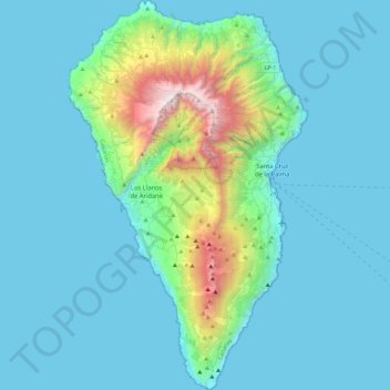
Name: La Palma topographic map, elevation, terrain.
Location: La Palma, Santa Cruz de Tenerife, Canary Islands, Spain (28.45269 -18.00725 28.85757 -17.72422)
Average elevation: 296 m
Minimum elevation: 0 m
Maximum elevation: 2,410 m
In a programme transmitted by the British Broadcasting Corporation BBC Horizon broadcast on 12 October 2000, two geologists (Day and McGuire) cited La Grieta as proof that half of the Cumbre Vieja had moved towards the Atlantic Ocean (Day et al. 1999, and Ward and Day, 2001). They postulate that this process was driven by the pressure caused by the rising magma heating water trapped within the structure of the island. They hypothesised that during a future eruption, the western flank of the Cumbre Vieja, with a mass of approximately 1.5 x10¹⁵ kg, could slide into the ocean. This could then potentially generate a giant wave, known as a "megatsunami" around 650–900 m (2,130–2,950 ft) high in the region of the islands. The wave would radiate out across the Atlantic and inundate much of the eastern seaboard of North America about 7 hours later, many of the islands in the Caribbean and northern coasts of South America between six and eight hours later. They estimate that the tsunami will have waves possibly 50 m (164 ft) or higher causing massive devastation along the coastlines. Modelling suggests that the tsunami could inundate up to 25 km (16 mi) inland – depending upon topography. The basis for Ward and Day (2001) modelling the collapse of a much larger portion of the western flank than what the currently visible surface crack indicates as being potentially unstable, was based on geological mapping by Day et al. (1999). In this paper they argue that a large part of the western flank has been constructed in the scar of a previous collapse and therefore sits upon unstable debris.
Other topographic maps
Click on a map to view its topography, its elevation and its terrain.
Truchas / Trueitas
Spain > Castile and León > Truchas
Truchas / Trueitas, Truchas, León, Castile and León, 24740, Spain
Average elevation: 1,210 m
Málaga
Spain > Andalusia > Málaga-Costa del Sol
Málaga, Málaga-Costa del Sol, Malaga, Andalusia, Spain
Average elevation: 276 m
As Brañas
Spain > Galicia > Betanzos > O Pazo de Irixoa
As Brañas, Mántaras, O Pazo de Irixoa, Irixoa, Betanzos, A Coruña, Galicia, 15313, Spain
Average elevation: 379 m
Barcelona
Spain > Catalonia > Barcelonès
Barcelona, Barcelonès, Barcelona, Catalonia, 08001, Spain
Average elevation: 65 m
As Brañas
Spain > Galicia > Bergantiños > A Laracha
As Brañas, Torás, A Laracha, Bergantiños, A Coruña, Galicia, 15145, Spain
Average elevation: 176 m
As Brañas
Spain > Galicia > A Mariña Oriental
As Brañas, San Pedro de Benquerencia, Barreiros, A Mariña Oriental, Lugo, Galicia, 27793, Spain
Average elevation: 20 m
Casas del Lomo
Casas del Lomo, Tejeda, Las Palmas, Canary Islands, 35360, Spain
Average elevation: 1,226 m
Iznate
Spain > Andalusia > La Axarquía
Iznate, La Axarquía, Malaga, Andalusia, 29792, Spain
Average elevation: 251 m
Granada
Spain > Andalusia > Comarca de la Vega de Granada
Granada, Comarca de la Vega de Granada, Granada, Andalusia, Spain
Average elevation: 829 m
Cornudella de Montsant
Cornudella de Montsant, Priorat, Tarragona, Catalonia, 43360, Spain
Average elevation: 700 m
Panticosa
Spain > Aragon > Alto Gállego
Panticosa, Alto Gállego, Huesca, Aragon, Spain
Average elevation: 1,916 m
Veleta
Spain > Castile and León > Valle del Retortillo
Veleta, Valle del Retortillo, Palencia, Castile and León, 34307, Spain
Average elevation: 791 m
Campell
Spain > Valencian Community > Pedreguer
Campell, Pedreguer, la Marina Alta, Alacant / Alicante, Valencian Community, 03750, Spain
Average elevation: 115 m
Ronda
Spain > Andalusia > Serranía de Ronda
Ronda, Serranía de Ronda, Malaga, Andalusia, Spain
Average elevation: 801 m
Alicante
Alicante, l'Alacantí, Alacant / Alicante, Valencian Community, Spain
Average elevation: 143 m
Trillo
Trillo, Guadalajara, Castile-La Mancha, 19450, Spain
Average elevation: 899 m
Sant Martí
Spain > Catalonia > Barcelonès > Barcelona
Sant Martí, Barcelona, Barcelonès, Barcelona, Catalonia, 08001, Spain
Average elevation: 17 m
Hospital
Spain > Galicia > Os Ancares > Pedrafita do Cebreiro
Hospital, Pedrafita do Cebreiro, Os Ancares, Lugo, Galicia, Spain
Average elevation: 1,184 m
Aldeatejada
Aldeatejada, Salamanca, Castile and León, Spain
Average elevation: 838 m
Vinaròs
Vinaròs, el Baix Maestrat, Castelló / Castellón, Valencian Community, 12500, Spain
Average elevation: 54 m
Vitales
Spain > Aragon > Hoya de Huesca / Plana de Uesca > Monflorite-Lascasas
Vitales, Monflorite-Lascasas, Hoya de Huesca / Plana de Uesca, Aragon, 22112, Spain
Average elevation: 492 m
Navajas
Navajas, l'Alt Palància, Castelló / Castellón, Valencian Community, 12470, Spain
Average elevation: 441 m
la Coma
Spain > Catalonia > Solsonès > la Coma i la Pedra
la Coma, la Coma i la Pedra, Solsonès, Lleida, Catalonia, 25284, Spain
Average elevation: 1,308 m
Benifato
Benifato, la Marina Baixa, Alacant / Alicante, Valencian Community, Spain
Average elevation: 939 m