
Wannock topographic map
Click on the map to display elevation.
About this map
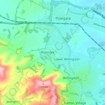
Name: Wannock topographic map, elevation, terrain.
Location: Wannock, Wealden, East Sussex, England, BN26 5PE, United Kingdom (50.79019 0.21606 50.83019 0.25606)
Average elevation: 50 m
Minimum elevation: 1 m
Maximum elevation: 198 m
East Sussex trails, hiking, mountain biking, running and outdoor activities
Other topographic maps
Click on a map to view its topography, its elevation and its terrain.
Ashdown Forest
United Kingdom > England > East Sussex > Wealden
Ashdown Forest is an ancient area of open heathland occupying the highest sandy ridge-top of the High Weald Area of Outstanding Natural Beauty. It is situated 30 miles (48 km) south of London in the county East Sussex, England. Rising to an elevation of 732 feet (223 m) above sea level, its heights provide…
Average elevation: 117 m
Punnetts Town Recreation Ground
United Kingdom > England > East Sussex > Wealden > Punnett's Town > Chapel Cross
Average elevation: 125 m
Crowborough
United Kingdom > England > East Sussex > Wealden
In the late 19th century, Crowborough was promoted as a health resort based on its high elevation, the rolling hills and surrounding forest. Estate Agents even called it "Scotland in Sussex". The town's golf course opened in 1895, followed by a fire station and hospital in 1900.
Average elevation: 146 m
Frant Lakes
United Kingdom > England > East Sussex > Wealden > Bells Yew Green
Average elevation: 110 m
Heathfield Park
United Kingdom > England > East Sussex > Wealden > Cade Street
Average elevation: 132 m
Broadwater Warren Nature Reserve
United Kingdom > England > East Sussex > Wealden > Groombridge
Average elevation: 84 m
Crowborough
United Kingdom > England > East Sussex > Wealden
In the late 19th century, Crowborough was promoted as a health resort based on its high elevation, the rolling hills and surrounding forest. Estate agents even called it "Scotland in Sussex". The town's golf course opened in 1895, followed by a fire station and hospital in 1900.
Average elevation: 146 m