
Arkansas topographic map
Click on the map to display elevation.
Arkansas
Arkansas's plant life varies with its climate and elevation. The pine belt stretching from the Arkansas delta to Texas consists of dense oak-hickory-pine growth. Lumbering and paper milling activity is active throughout the region. In eastern Arkansas, one can find Taxodium (cypress), Quercus nigra (water oaks), and hickories with their roots submerged in the Mississippi Valley bayous indicative of the deep south. Nearby Crowley's Ridge is the only home of the tulip tree in the state, and generally hosts more northeastern plant life such as the beech tree. The northwestern highlands are covered in an oak-hickory mixture, with Ozark white cedars, cornus (dogwoods), and Cercis canadensis (redbuds) also present. The higher peaks in the Arkansas River Valley play host to scores of ferns, including the Woodsia scopulina and Adiantum (maidenhair fern) on Mount Magazine. Arkansas wildlife is famous for the white-tailed deer, elk, and bald eagle. The white-tailed deer is the official state mammal.
About this map
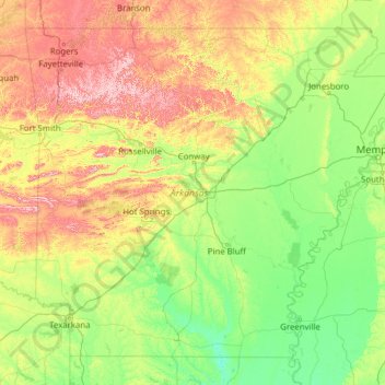
Name: Arkansas topographic map, elevation, terrain.
Location: Arkansas, United States (33.00425 -94.61788 36.49960 -89.64440)
Average elevation: 156 m
Minimum elevation: 13 m
Maximum elevation: 817 m
Other topographic maps
Click on a map to view its topography, its elevation and its terrain.
San Francisco Bay Area
United States > California > San Francisco
The San Francisco Bay Area is characterized by a diverse and dynamic topography shaped by geological processes over millions of years. This region features a combination of coastal plains, steep hills, and rugged mountains, all influenced by the tectonic activity associated with the nearby San Andreas Fault…
Average elevation: 113 m
Appalachian Mountains
United States > North Carolina > Yancey County
The Appalachian Mountains (French: Appalaches), often called the Appalachians, are a system of mountains in eastern to northeastern North America. The Appalachians first formed roughly 480 million years ago during the Ordovician Period. They once reached elevations similar to those of the Alps and the Rocky…
Average elevation: 1,463 m
Baltimore
United States > Maryland > Baltimore
Baltimore is in north-central Maryland on the Patapsco River close to where it empties into the Chesapeake Bay. The city is also located on the fall line between the Piedmont Plateau and the Atlantic coastal plain, which divides Baltimore into "lower city" and "upper city". The city's elevation ranges from sea…
Average elevation: 65 m
Virginia Beach
United States > Virginia > Virginia Beach
According to the United States Census Bureau, the city has a total area of 497 square miles (1,290 km2), of which 249 square miles (640 km2) is land and 248 square miles (640 km2) (49.9%) is water. It is the largest city in Virginia by total area and third-largest city land area. The average elevation is 12…
Average elevation: 2 m
Santa Cruz Mountains
United States > California > Santa Clara County
The Santa Cruz Mountains are a region of great biological diversity, encompassing cool, moist coastal ecosystems as well as warm, dry chaparral. Much of the area in the Santa Cruz mountains is considered temperate rainforest. In valleys and moist ocean-facing slopes some of the southernmost coast redwoods…
Average elevation: 230 m
Palm Harbor
United States > Florida > Pinellas County
Palm Harbor is characterized by its unique topography, which features a relatively rare hilly landscape for the region. Unlike much of the surrounding areas in Pinellas County, which are predominantly flat, Palm Harbor includes elevations that can reach up to about 75 feet above sea level. This elevation gives…
Average elevation: 9 m
Scottsdale
United States > Arizona > Maricopa County > Scottsdale
The city is in the Salt River Valley, or the "Valley of the Sun," in the northern reaches of the Sonoran Desert. Scottsdale, 31 mi (50 km) long and 11.4 mi (18.3 km) wide at its widest point, shares boundaries with many other municipalities and entities. On the west, Scottsdale is bordered by Phoenix, Paradise…
Average elevation: 414 m
Willcox
United States > Arizona > Cochise County
Willcox's high elevation gives it a milder climate than the nearby Valley of the Sun and Sonoran Desert. It also receives more rainfall than Tucson and Phoenix due to the summer monsoon rains and thus it has a hot semi-arid climate (Koppen: BSh)
Average elevation: 1,274 m
Pocono Summit
United States > Pennsylvania > Monroe County > Tobyhanna Township
Average elevation: 550 m
Evergreen
United States > Colorado > Jefferson County
Evergreen sits at an elevation of 7,220 feet (2,200 m) in the Rocky Mountains, 19 miles west of Denver, Colorado. Its addresses are oriented according to the Street_system_of_Denver.
Average elevation: 2,309 m
Georgetown
United States > Texas > Georgetown
The city is located on the northeastern edge of Texas Hill Country. Portions of Georgetown are located on either side of the Balcones Escarpment, a fault line in which the areas roughly east of IH-35 are flat and characterized by having black, fertile soils of the Blackland Prairie, and the west side of the…
Average elevation: 219 m
Appalachian Mountains
United States > North Carolina > Yancey County
The Appalachian Mountains (French: Appalaches), often called the Appalachians, are a system of mountains in eastern to northeastern North America. The Appalachians first formed roughly 480 million years ago during the Ordovician Period. They once reached elevations similar to those of the Alps and the Rocky…
Average elevation: 1,463 m
Parrish
United States > Florida > Manatee County
Parrish features a predominantly flat terrain with an average elevation of approximately 36 feet above sea level. The area's landscape is characterized by gently rolling hills and low-lying regions, making it typical of the Central Florida topography. Surrounding Parrish are numerous wetlands and drainage…
Average elevation: 12 m
Kecksburg
United States > Pennsylvania > Westmoreland County > Mount Pleasant Township
Average elevation: 404 m
Wolf Creek Lake
United States > North Carolina > Jackson County > Wolf Mountain
Average elevation: 1,021 m
Browns Corner
United States > Connecticut > Northwest Hills Planning Region > New Hartford
Average elevation: 212 m
Mount Katahdin
United States > Maine > Piscataquis County > Mount Katahdin Township
It is commonly thought that Katahdin is the first place in the United States mainland to receive sunlight in the morning, but this is incorrect. Other mountains lower in elevation but farther to the east or southeast see the first sunrise of the day, depending on the season. Regardless, the summit of Katahdin…
Average elevation: 1,216 m
Little Saint James Island
United States > United States Virgin Islands > Saint Thomas - Saint John District
Average elevation: 1 m
Rancho Peñasquitos
United States > California > San Diego County > San Diego
The highest point in the community is Black Mountain, which rises to an elevation of 1,500 feet (460 m).
Average elevation: 157 m
Albuquerque
United States > New Mexico > Bernalillo County
Albuquerque is located in north-central New Mexico. To its east are the Sandia–Manzano Mountains. The Rio Grande flows north to south through its center, while the West Mesa and Petroglyph National Monument make up the western part of the city. Albuquerque has one of the highest elevations of any major city…
Average elevation: 1,671 m
Longwood Gardens
United States > Pennsylvania > Chester County > East Marlborough Township
Average elevation: 125 m
Indianapolis
United States > Indiana > Indianapolis
Indianapolis is within the Tipton Till Plain, a flat to gently sloping terrain underlain by glacial deposits known as till. The lowest point in the city is about 650 feet (198 m) above mean sea level, with the highest natural elevation at about 900 feet (274 m) above sea level. Few hills or short ridges, known…
Average elevation: 241 m
Uinta Mountains
The high Uintas were extensively glaciated during the last ice age, and most of the large stream valleys on both the north and south sides of the range held long valley glaciers. However, despite reaching to over 13,500 feet (4,110 m) in elevation, the climate today is sufficiently dry that no glaciers…
Average elevation: 2,363 m
Ponte Vedra Beach
United States > Florida > Saint Johns County > Ponte Vedra Beach
Ponte Vedra Beach is characterized by its gently rolling terrain that is primarily flat and lies only about 15 feet above sea level. The landscape is predominantly shaped by coastal dunes and the proximity to the Atlantic Ocean, resulting in sandy beaches interspersed with vegetation typical of barrier island…
Average elevation: 3 m
Newalla
United States > Oklahoma > Oklahoma County > Oklahoma City
Newalla, with a current elevation of 1,148 feet, is located within the Eastern bounds of Oklahoma County and appears on the Harrah, Oklahoma U.S. Geological Survey Map due to their proximity. Newalla is a geographic area which spans unincorporated Oklahoma County and unincorporated Cleveland County (also…
Average elevation: 343 m
Humphreys Peak
United States > Arizona > Coconino County
Humphreys Peak (Hopi: Aaloosaktukwi, Navajo: Dookʼoʼoosłííd "its summit never melts") is the highest mountain and the second most prominent peak after Mount Graham in the U.S. state of Arizona. With an elevation of 12,637 feet (3,852 m), it is located within the Kachina Peaks Wilderness in the Coconino…
Average elevation: 3,412 m
Johnston Island
The climate is tropical but generally dry. Northeast trade winds are consistent and there is little seasonal temperature variation. With elevation ranging from sea level to 5 m (16 ft) at Summit Peak, the islands contain some low-growing vegetation and palm trees on mostly flat terrain, and no natural fresh…
Average elevation: 1 m
Lake Peekskill
United States > New York > Putnam County > Town of Putnam Valley
Average elevation: 103 m
Phoenix
United States > Arizona > Maricopa County > Phoenix
Phoenix is in the south-central portion of Arizona; about halfway between Tucson to the southeast and Flagstaff to the north, in the southwestern United States. By car, the city is approximately 150 miles (240 kilometers) north of the US–Mexico border at Sonoyta and 180 mi (290 km) north of the border at…
Average elevation: 368 m
Groveland
United States > California > Tuolumne County
Groveland is a census-designated place (CDP) in Tuolumne County, California. Groveland sits at an elevation of 3,136 feet (956 m). The 2020 United States census reported Groveland's population was 540.
Average elevation: 898 m
Vinings
United States > Georgia > Cobb County
Vinings features a varied topography characterized by rolling hills and lush, wooded areas that provide a picturesque backdrop to the community. The area is nestled alongside the Chattahoochee River, which contributes to the gentle slopes and valleys that define the landscape. Elevations in Vinings typically…
Average elevation: 281 m
Black Hills
United States > South Dakota > Pennington County
The Black Hills is an isolated mountain range rising from the Great Plains of North America in western South Dakota and extending into Wyoming, United States. Black Elk Peak, which rises to 7,242 feet (2,207 m), is the range's highest summit. The name of the range in Lakota is Pahá Sápa. It encompasses the…
Average elevation: 1,894 m
Cajon Pass
United States > California > San Bernardino County
Cajon Pass (/kəˈhoʊn/; Spanish: Puerto del Cajón or Paso del Cajón) is a mountain pass between the San Bernardino Mountains to the east and the San Gabriel Mountains to the west in Southern California. Created by the movements of the San Andreas Fault, it has an elevation of 3,777 ft (1,151 m). Located in…
Average elevation: 1,169 m
Palmyra Atoll
In 1962, the Department of Defense used Palmyra as an observation site during several high-altitude nuclear weapons tests high above Johnston Atoll. A group of about ten men supported the observation posts during this series of tests, while about 40 people carried out the observations.
Average elevation: 0 m
Mauna Kea
United States > Hawaii > Hawaiʻi County
Mauna Kea (/ˌmaʊnə ˈkeɪə/; Hawaiian: [ˈmɐwnə ˈkɛjə]; abbreviation for Mauna a Wākea) is a dormant volcano on the island of Hawaiʻi. Its peak is 4,207.3 m (13,803 ft) above sea level, making it the highest point in the state of Hawaiʻi and second-highest peak of an island on Earth. The peak is…
Average elevation: 3,978 m
Central Park
United States > New York > New York County > New York
In June 1856, Fernando Wood appointed a "consulting board" of seven people, headed by author Washington Irving, to inspire public confidence in the proposed development. Wood hired military engineer Egbert Ludovicus Viele as the park's chief engineer, tasking him with a topographical survey of the site. The…
Average elevation: 26 m
Old Mission
United States > Michigan > Grand Traverse County
Old Mission is located just east of M-37 near the tip of Old Mission Peninsula about 16 miles (25.75 km) north of Traverse City. The community was built along Old Mission Harbor, which is a small safe haven along the East Arm of Grand Traverse Bay. The community sits at an elevation of 587 feet (179 m) above…
Average elevation: 190 m
Blood Mountain
United States > Georgia > Union County
Blood Mountain is the highest peak on the Georgia section of the Appalachian Trail and the sixth-tallest mountain in Georgia, with an elevation of 4,458 feet (1,359 m). It is located on the border of Lumpkin County with Union County and is within the boundaries of the Chattahoochee National Forest and the…
Average elevation: 1,048 m
Coarsegold
United States > California > Madera County
Coarsegold is located on Highway 41 between Fresno and the southern entrance to Yosemite National Park, at an elevation of 2,218 ft (676 m). Fresno is 38 miles (61 km) to the south, and the south entrance of Yosemite is 23 miles (37 km) to the north. Nearby communities include Oakhurst 8 miles (13 km) to the…
Average elevation: 764 m