
Make a donation
Gear up for your next adventure:
As an Amazon Associate, this site earns from qualifying purchases at no extra cost to you.
Sandwell topographic map
Click on the map to display elevation.
Make a donation
Gear up for your next adventure:
As an Amazon Associate, this site earns from qualifying purchases at no extra cost to you.
About this map
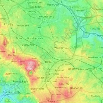
Name: Sandwell topographic map, elevation, terrain.
Location: Sandwell, West Midlands, England, United Kingdom (52.46072 -2.09711 52.56907 -1.91816)
Average elevation: 152 m
Minimum elevation: 86 m
Maximum elevation: 270 m
England trails, hiking, mountain biking, running and outdoor activities
Make a donation
Gear up for your next adventure:
As an Amazon Associate, this site earns from qualifying purchases at no extra cost to you.
Other topographic maps
Click on a map to view its topography, its elevation and its terrain.
Cambridge
United Kingdom > England > Cambridge
The city, like most of the UK, has a maritime climate highly influenced by the Gulf Stream. Located in the driest region of Britain, Cambridge's rainfall averages around 570 mm (22.44 in) per year, around half the national average, with some years occasionally falling into the semi-arid (under 500 mm (19.69…
Average elevation: 18 m
Make a donation
Gear up for your next adventure:
As an Amazon Associate, this site earns from qualifying purchases at no extra cost to you.
Make a donation
Gear up for your next adventure:
As an Amazon Associate, this site earns from qualifying purchases at no extra cost to you.
Castle Donington
United Kingdom > England > North West Leicestershire > Castle Donington
Average elevation: 62 m
Make a donation
Gear up for your next adventure:
As an Amazon Associate, this site earns from qualifying purchases at no extra cost to you.
Atherton
There were several ministers of note of Chowbent Chapel including James Wood, the "General" (1672–1759), who distinguished himself at the Battle of Preston in 1715. Thomas Walker Horsfield (1792–1837) was a historian and topographer. Joseph Nightingale (1775–1824), born in Chowbent, was a prolific…
Average elevation: 69 m
Wallasey
Wallasey is situated at the north-east of the Wirral Peninsula, on the western side of the River Mersey and adjoining the Irish Sea. The area is approximately 9.5 km (5.9 mi) east-north-east of the Dee Estuary at Hoylake. Wallasey is at an elevation of between 0–50 m (0–164 ft) above sea level, with the…
Average elevation: 12 m
Make a donation
Gear up for your next adventure:
As an Amazon Associate, this site earns from qualifying purchases at no extra cost to you.
Make a donation
Gear up for your next adventure:
As an Amazon Associate, this site earns from qualifying purchases at no extra cost to you.
Make a donation
Gear up for your next adventure:
As an Amazon Associate, this site earns from qualifying purchases at no extra cost to you.
Make a donation
Gear up for your next adventure:
As an Amazon Associate, this site earns from qualifying purchases at no extra cost to you.
Make a donation
Gear up for your next adventure:
As an Amazon Associate, this site earns from qualifying purchases at no extra cost to you.
Make a donation
Gear up for your next adventure:
As an Amazon Associate, this site earns from qualifying purchases at no extra cost to you.
Hull
United Kingdom > England > Kingston upon Hull
Kingston upon Hull is on the northern bank of the Humber Estuary. The city centre is west of the River Hull and close to the Humber. The city is built upon alluvial and glacial deposits which overlie chalk rocks but the underlying chalk has no influence on the topography. The land within the city is generally…
Average elevation: 21 m
Make a donation
Gear up for your next adventure:
As an Amazon Associate, this site earns from qualifying purchases at no extra cost to you.
Bedford
United Kingdom > England > Bedford
As with the rest of the United Kingdom, Bedford has a maritime climate, with a limited range of temperatures, and generally even rainfall throughout the year. The nearest Met Office weather station to Bedford is Bedford (Thurleigh) airport, about 6.5 miles (10.5 km) north of Bedford town centre at an elevation…
Average elevation: 37 m
Make a donation
Gear up for your next adventure:
As an Amazon Associate, this site earns from qualifying purchases at no extra cost to you.
Swindon
United Kingdom > England > Swindon
Swindon has an oceanic climate (Cfb in the Köppen climate classification), like the vast majority of the British Isles, with cool winters and warm summers. The nearest official weather station is RAF Lyneham, about 10 miles (16 km) west southwest of Swindon town centre. The weather station's elevation is 145…
Average elevation: 108 m
Make a donation
Gear up for your next adventure:
As an Amazon Associate, this site earns from qualifying purchases at no extra cost to you.
Make a donation
Gear up for your next adventure:
As an Amazon Associate, this site earns from qualifying purchases at no extra cost to you.
Make a donation
Gear up for your next adventure:
As an Amazon Associate, this site earns from qualifying purchases at no extra cost to you.
Rother Valley Country Park
United Kingdom > England > Derbyshire > Rotherham > Swallownest
Average elevation: 62 m
Donnington Park
United Kingdom > England > West Sussex > Chichester > Donnington
Average elevation: 8 m
Make a donation
Gear up for your next adventure:
As an Amazon Associate, this site earns from qualifying purchases at no extra cost to you.
Make a donation
Gear up for your next adventure:
As an Amazon Associate, this site earns from qualifying purchases at no extra cost to you.
Basingstoke
United Kingdom > England > Hampshire > Basingstoke and Deane
Situated in a valley through the Hampshire Downs at an average elevation of 88 metres (289 ft) Basingstoke is a major interchange between Reading, Newbury, Andover, Winchester, and Alton, and lies on the natural trade route between the southwest of England and London. The area had been something of an…
Average elevation: 107 m
Make a donation
Gear up for your next adventure:
As an Amazon Associate, this site earns from qualifying purchases at no extra cost to you.
Leeds
Lying in the eastern foothills of the Pennines, there is a significant variation in elevation within the city's built-up area. The district ranges from 1,115 feet (340 m) in the far west on the slopes of Ilkley Moor to about 33 feet (10 m) where the rivers Aire and Wharfe cross the eastern boundary. Land rises…
Average elevation: 94 m
Make a donation
Gear up for your next adventure:
As an Amazon Associate, this site earns from qualifying purchases at no extra cost to you.
Make a donation
Gear up for your next adventure:
As an Amazon Associate, this site earns from qualifying purchases at no extra cost to you.
Helvellyn
United Kingdom > England > Westmorland and Furness > Patterdale
Red Tarn, a classic corrie tarn, is a high-elevation tarn with low nutrient levels and poor in the number of species it supports. Characteristic vegetation zones include a water-starwort (Callitriche) in shallower areas and the alga Nitella flexilis in deeper water and around the inlet. Other species include a…
Average elevation: 680 m
Weston Park
United Kingdom > England > Staffordshire > South Staffordshire > Weston under Lizard
Average elevation: 113 m
Make a donation
Gear up for your next adventure:
As an Amazon Associate, this site earns from qualifying purchases at no extra cost to you.
Make a donation
Gear up for your next adventure:
As an Amazon Associate, this site earns from qualifying purchases at no extra cost to you.
Alderley Edge
United Kingdom > England > Alderley Edge
Alderley Edge is 6 miles (10 km) northwest of Macclesfield and 15 miles (24 km) south of Manchester, at the base of a steep and thickly wooded sandstone escarpment, Alderley Edge, which is the area's chief topographical feature and overlooks the Cheshire Plain.
Average elevation: 92 m
Make a donation
Gear up for your next adventure:
As an Amazon Associate, this site earns from qualifying purchases at no extra cost to you.
Make a donation
Gear up for your next adventure:
As an Amazon Associate, this site earns from qualifying purchases at no extra cost to you.
Make a donation
Gear up for your next adventure:
As an Amazon Associate, this site earns from qualifying purchases at no extra cost to you.
Portsmouth
United Kingdom > England > Hampshire > Portsmouth
By road, Portsmouth lies 73.5 miles (118.3 km) from Central London, 49.5 miles (79.7 km) west of Brighton, and 22.3 miles (35.9 km) east of Southampton. Portsmouth is situated primarily on Portsea Island and is the United Kingdom's only island city, although parts of it have expanded onto the mainland. Gosport…
Average elevation: 28 m
Romford
United Kingdom > England > Greater London
The town centre is about 50 feet (15 m) above sea level on a gravel terrace rising from the River Thames. The north of the town has developed on London Clay and is situated as much as 150 ft (46 m) above sea level. A continuous gentle rise in the eastern suburbs towards Gidea Park and Harold Wood peaks around…
Average elevation: 29 m
Make a donation
Gear up for your next adventure:
As an Amazon Associate, this site earns from qualifying purchases at no extra cost to you.