
Viqueque topographic map
Interactive map
Click on the map to display elevation.
About this map
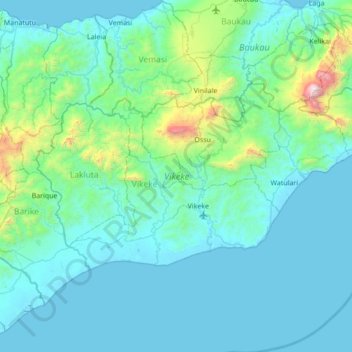
Name: Viqueque topographic map, elevation, terrain.
Location: Viqueque, East Timor (-8.99087 126.04620 -8.62825 126.73764)
Average elevation: 237 m
Minimum elevation: -1 m
Maximum elevation: 2,305 m
Other topographic maps
Click on a map to view its topography, its elevation and its terrain.
Aeroporto
East Timor > Dili > Aeroporto
Aeroporto, Dom Aleixo, Dili, 61054, East Timor
Average elevation: 16 m
Porlamano
East Timor > Lautém > Porlamano
Porlamano, Tutuala, Lautém, East Timor
Average elevation: 394 m
Lakonakbesik
East Timor > Cova Lima > Lakonakbesik
Lakonakbesik, Cova Lima, East Timor
Average elevation: 42 m