
Hebi topographic map
Interactive map
Click on the map to display elevation.
About this map
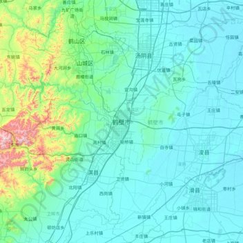
Name: Hebi topographic map, elevation, terrain.
Location: Hebi, Henan, China (35.44344 113.98973 36.05235 114.74634)
Average elevation: 162 m
Minimum elevation: 53 m
Maximum elevation: 1,043 m
Other topographic maps
Click on a map to view its topography, its elevation and its terrain.
Yudu Subdistrict
China > Henan > Zhenping County > Nanyang
Yudu Subdistrict, Zhenping County, Nanyang, Henan, China
Average elevation: 240 m
Luyang Subdistrict
China > Henan > Lushan County > Pingdingshan
Luyang Subdistrict, Lushan County, Pingdingshan, Henan, China
Average elevation: 132 m
Suiyang District
Suiyang District, Shangqiu, Henan, China
Average elevation: 48 m
Yellow River
China > Henan > Taiqian County
Yellow River, Taiqian County, Puyang City, Henan, China
Average elevation: 43 m
Weihe River
China > Henan > Muye District > Wangcun
Weihe River, Wangcun, Muye District, Xinxiang City, Henan, 453000, China
Average elevation: 75 m
Yanshi District
Yanshi District, Luoyang, Henan, 471943, China
Average elevation: 271 m
Huaxian
China > Henan > Hua County > Baidaokou
Huaxian, Baidaokou, Hua County, Anyang City, Henan, China
Average elevation: 64 m
Dengzhou City
China > Henan > Dengzhou City
Dengzhou City, Nanyang City, Henan, China
Average elevation: 129 m
Nanzhao County
China > Henan > Nanyang City
Nanzhao County, Nanyang City, Henan, China
Average elevation: 467 m
Chengjiao
China > Henan > Weihui City
Chengjiao, Weihui City, Xinxiang, Henan, China
Average elevation: 71 m
Xichuan
China > Henan > Xichuan County > Xichuan
Xichuan, Xichuan County, Nanyang City, Henan, China
Average elevation: 327 m
Lingbao City
China > Henan > Lingbao City
Lingbao City, Sanmenxia City, Henan, China
Average elevation: 854 m
Xiaolangdi
China > Henan > Xiaolangdi
Xiaolangdi, Mengjin County, Luoyang City, Henan, China
Average elevation: 371 m
Shilong District
China > Henan > Pingdingshan City
Shilong District, Pingdingshan City, Henan, China
Average elevation: 230 m
Mangshan Subdistrict
China > Henan > Mangshan Subdistrict
Mangshan Subdistrict, Laocheng District, Luoyang City, Henan, China
Average elevation: 216 m
Sanmenxia
China > Henan > Yadi Subdistrict
Sanmenxia, Yadi Subdistrict, Hubin District, Sanmenxia City, Henan, China
Average elevation: 577 m