
Seferihisar topographic map
Interactive map
Click on the map to display elevation.
About this map
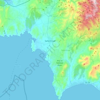
Name: Seferihisar topographic map, elevation, terrain.
Location: Seferihisar, Izmir, Aegean Region, Turkey (38.03015 26.75084 38.30918 26.99234)
Average elevation: 128 m
Minimum elevation: 0 m
Maximum elevation: 962 m
Seferihisar is a coastal district and the center town of the same district in İzmir Province, in Turkey. Seferihisar district area borders on other İzmir districts of Urla to the west and Menderes (Cumaovası) to the east, and touches İzmir's westernmost metropolitan district of Güzelbahçe in the north. Seferihisar town center is situated slightly inland at an altitude of 28 m and the urban area extends towards the sea as composed of eight quarters, with some distance among some, and one of which, the neighborhood called Sığacık stands somewhat separately from the rest at a distance of 5 km, and has its own port and made a name as a tourism resort by its own right. The wide area of the district center partly accounts for the high number of the population and an urbanization rate of only 51%, and the general impression observed is rather rural in some of its sections. Both the center town and the district as a whole preserves an overall outlook of a pleasant resort area bearing typical Aegean characteristics and it is estimated the population reaches the level of 150,000 people during the touristic season. Nevertheless, the district's economy is still largely based on agriculture, with the production of tangerines and satsumas standing out, and only increasingly on tourism, with the presence of several housing projects or vacation villages, pensioners opting to settle in the region due to its quiet charm and under the impetus of a university campus that is in phase of being built. At a distance of 45 km (28 mi) from İzmir center, (Konak), the connections with the metropolis are made easily, especially once reached the six-lane highway in Urla. Seferihisar is where the ancient city of Teos is located and its highly interesting await further research and discoveries. The district's literacy level is 99%.
Other topographic maps
Click on a map to view its topography, its elevation and its terrain.
Tepebaşı Mahallesi
Tepebaşı Mahallesi, Keçiören, Ankara, Central Anatolia Region, Turkey
Average elevation: 945 m
Hacıbektaş İlçe Merkezi
Hacıbektaş İlçe Merkezi, Hacıbektaş, Nevşehir, Central Anatolia Region, 50800, Turkey
Average elevation: 1,221 m
Güneyce Mahallesi
Güneyce Mahallesi, Güdül, Ankara, Central Anatolia Region, Turkey
Average elevation: 819 m
Göztepe Mahallesi
Göztepe Mahallesi, Izmir, Konak, Izmir, Aegean Region, Turkey
Average elevation: 38 m
Sığacık Mahallesi
Sığacık Mahallesi, Seferihisar, Izmir, Aegean Region, Turkey
Average elevation: 22 m
Alaçatı Mahallesi
Alaçatı Mahallesi, Çeşme, Izmir, Aegean Region, Turkey
Average elevation: 40 m
Balbey Mahallesi
Balbey Mahallesi, Antalya, Muratpaşa, Antalya, Mediterranean Region, Turkey
Average elevation: 43 m
Sığacık Mahallesi
Sığacık Mahallesi, Bozova, Şanlıurfa, Southeastern Anatolia Region, Turkey
Average elevation: 523 m
DF
Turkey > Borçka > Goman Yaylası
DF, Goman Yaylası, Borçka, Artvin, Black Sea Region, Turkey
Average elevation: 2,157 m
Cappadocia
Turkey > Central Anatolia Region > Göreme
Cappadocia, Göreme, Nevşehir merkez, Nevşehir, Central Anatolia Region, 50650, Turkey
Average elevation: 1,144 m
Gençlik Parkı
Gençlik Parkı, Hacı Bayram Mahallesi, Altındağ, Ankara, Central Anatolia Region, Turkey
Average elevation: 870 m
Polonezköy Mahallesi
Polonezköy Mahallesi, Beykoz, Istanbul, Marmara Region, Turkey
Average elevation: 147 m
Kuşsaray
Kuşsaray, Çorum Merkez, Çorum, Black Sea Region, Turkey
Average elevation: 1,129 m
İskele Mahallesi
İskele Mahallesi, Urla, Izmir, Aegean Region, Turkey
Average elevation: 55 m
Karahacılı
Karahacılı, Silifke, Mersin, Mediterranean Region, Turkey
Average elevation: 362 m
Kocatepe Mahallesi
Kocatepe Mahallesi, Çankaya, Ankara, Central Anatolia Region, 06660, Turkey
Average elevation: 896 m
Gülbahçe Mahallesi
Gülbahçe Mahallesi, Urla, Izmir, Aegean Region, 35433, Turkey
Average elevation: 93 m
Çıralı obruğu
Çıralı obruğu, Karapınar, Konya, Central Anatolia Region, Turkey
Average elevation: 1,048 m
Kümperli
Kümperli, Onikişubat, Kahramanmaraş, Mediterranean Region, Turkey
Average elevation: 1,116 m
Harbiye Mahallesi
Harbiye Mahallesi, Çankaya, Ankara, Central Anatolia Region, Turkey
Average elevation: 1,004 m
Yukarı Çanlı
Yukarı Çanlı, Kızılcahamam, Ankara, Central Anatolia Region, Turkey
Average elevation: 1,413 m