
Chicot County topographic map
Interactive map
Click on the map to display elevation.
About this map
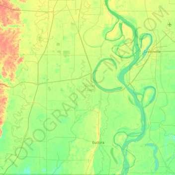
Name: Chicot County topographic map, elevation, terrain.
Location: Chicot County, Arkansas, United States (33.00425 -91.46042 33.56364 -91.04362)
Average elevation: 37 m
Minimum elevation: 24 m
Maximum elevation: 64 m
Other topographic maps
Click on a map to view its topography, its elevation and its terrain.
Magazine Mountain
United States > Arkansas > Logan County
Mount Magazine is often called "the highest point between the Alleghenies and the Rockies" (there are mountains located in the Trans-Pecos region of far-west Texas which exceed Mount Magazine in elevation and prominence, although the Trans-Pecos region lies so far south of the Rockies, that region arguably…
Average elevation: 670 m