
Borough of Luton topographic map
Interactive map
Click on the map to display elevation.
About this map
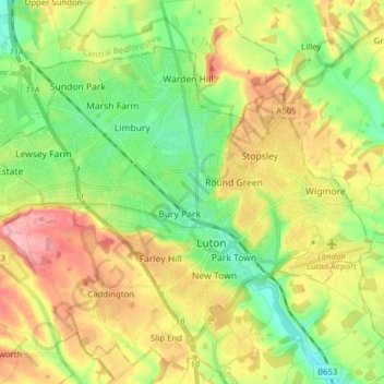
Name: Borough of Luton topographic map, elevation, terrain.
Location: Borough of Luton, England, United Kingdom (51.85447 -0.50595 51.92774 -0.34992)
Average elevation: 146 m
Minimum elevation: 94 m
Maximum elevation: 215 m
The local climate around Luton is differentiated somewhat from much of South East England due to its position in the Chiltern Hills, meaning it tends to be 1–2 degrees Celsius cooler than the surrounding towns – often flights at Luton airport, lying 160 m (525 ft) above sea level, will be suspended when marginal snow events occur, while airports at lower elevations, such as Heathrow, at 25 m (82 ft) above sea level, continue to function. An example of this is shown in the photograph to the right, the snowline being about 100 m (328 ft) above sea level. Absolute temperature extremes recorded at Rothamsted Research Station, 5 miles (8 km) south south east of Luton town centre and at a similar elevation range from −17.0 °C (1.4 °F) in December 1981 and −16.7 °C (1.9 °F) in January 1963 to 36.6 °C (97.9 °F) in July 2019 and 33.8 °C (92.8 °F) in August 1990 and July 2006. Records for Rothamsted date back to 1901.
Other topographic maps
Click on a map to view its topography, its elevation and its terrain.
London
United Kingdom > England > London
London, Greater London, England, SW1A 2DX, United Kingdom
Average elevation: 42 m
Bristol
United Kingdom > England > City of Bristol
Bristol, City of Bristol, West of England, England, United Kingdom
Average elevation: 55 m
Liverpool
Liverpool, Liverpool City Region, England, United Kingdom
Average elevation: 26 m
London
London, Greater London, England, United Kingdom
Average elevation: 66 m
Norwich
United Kingdom > England > Norfolk
Norwich, Norfolk, England, United Kingdom
Average elevation: 28 m
Sheffield
Sheffield, South Yorkshire, England, United Kingdom
Average elevation: 168 m
Birmingham
Birmingham, West Midlands Combined Authority, England, United Kingdom
Average elevation: 138 m
Guildford
United Kingdom > England > Surrey
Guildford, Surrey, England, United Kingdom
Average elevation: 74 m
Hull
United Kingdom > England > Kingston upon Hull
Hull, Kingston upon Hull, England, HU1 3RJ, United Kingdom
Average elevation: 21 m
North Norfolk
United Kingdom > England > Norfolk
North Norfolk, Norfolk, England, United Kingdom
Average elevation: 26 m
Somerset
Somerset, South West England, England, United Kingdom
Average elevation: 87 m
Hampshire
Hampshire, South East, England, United Kingdom
Average elevation: 73 m
Brighton
United Kingdom > England > Brighton and Hove
Brighton, Brighton and Hove, England, United Kingdom
Average elevation: 64 m
Leeds
United Kingdom > England > Leeds
Leeds, Yorkshire and the Humber, England, LS1 6AL, United Kingdom
Average elevation: 94 m
Enfield
United Kingdom > England > London
Enfield, Greater London, England, EN2 6LD, United Kingdom
Average elevation: 39 m
Bath
United Kingdom > England > Bath and North East Somerset
Bath, Bath and North East Somerset, West of England, England, United Kingdom
Average elevation: 100 m
Winchester
United Kingdom > England > Hampshire
Winchester, Hampshire, England, United Kingdom
Average elevation: 73 m
Milton Keynes
United Kingdom > England > Milton Keynes > Milton Keynes
Milton Keynes, South East England, England, MK9 3AF, United Kingdom
Average elevation: 81 m
Derby
United Kingdom > England > Derbyshire
Derby, Derbyshire, England, DE1 2AA, United Kingdom
Average elevation: 96 m
Spalding
United Kingdom > England > Lincolnshire > South Holland
Spalding, South Holland, Lincolnshire, England, United Kingdom
Average elevation: 4 m
Cheltenham
United Kingdom > England > Gloucestershire
Cheltenham, Gloucestershire, England, United Kingdom
Average elevation: 109 m
St Albans
United Kingdom > England > Hertfordshire > St Albans
St Albans, Hertfordshire, East of England, England, United Kingdom
Average elevation: 100 m
East of England
East of England, England, United Kingdom
Average elevation: 39 m
Greater London
Greater London, England, United Kingdom
Average elevation: 66 m
Plymouth
United Kingdom > England > Devon > Plymouth
Plymouth, Devon, South West England, England, PL1 1HH, United Kingdom
Average elevation: 81 m
Northamptonshire
Northamptonshire, England, United Kingdom
Average elevation: 97 m
North Yorkshire
North Yorkshire, Yorkshire and the Humber, England, United Kingdom
Average elevation: 153 m
Worksop
United Kingdom > England > Nottinghamshire > Bassetlaw
Worksop, Bassetlaw, Nottinghamshire, England, S80 1JB, United Kingdom
Average elevation: 56 m
Chichester
United Kingdom > England > Chichester
Chichester, West Sussex, South East, England, United Kingdom
Average elevation: 57 m
Nottingham
United Kingdom > England > Nottinghamshire
Nottingham, England, United Kingdom
Average elevation: 56 m
Durham
United Kingdom > England > County Durham
Durham, County Durham, North East, England, DH1 3NG, United Kingdom
Average elevation: 119 m
Lincolnshire
Lincolnshire, East Midlands, England, United Kingdom
Average elevation: 28 m
Huddersfield
United Kingdom > England > Kirklees
Huddersfield, Kirklees, West Yorkshire, England, HD1 2AA, United Kingdom
Average elevation: 145 m
Portsmouth
United Kingdom > England > Hampshire > Portsmouth
Portsmouth, Hampshire, South East England, England, PO1 5QH, United Kingdom
Average elevation: 28 m
Loughborough
United Kingdom > England > Leicestershire > Charnwood
Loughborough, Charnwood, Leicestershire, England, LE11 5BJ, United Kingdom
Average elevation: 61 m
Oxford
United Kingdom > England > Oxfordshire
Oxford, Oxfordshire, England, United Kingdom
Average elevation: 81 m
Leicester
United Kingdom > England > Leicestershire
Leicester, Leicestershire, England, LE1 5YA, United Kingdom
Average elevation: 109 m
Peterborough
United Kingdom > England > City of Peterborough
Peterborough, City of Peterborough, Cambridgeshire and Peterborough, England, PE1 1XH, United Kingdom
Average elevation: 17 m