
Make a donation
Gear up for your next adventure:
As an Amazon Associate, this site earns from qualifying purchases at no extra cost to you.
Vienna topographic map
Click on the map to display elevation.
Gear up for your next adventure:
As an Amazon Associate, this site earns from qualifying purchases at no extra cost to you.
Vienna
Vienna is located in northeastern Austria, at the easternmost extension of the Alps in the Vienna Basin. The earliest settlement, at the location of today's inner city, was south of the meandering Danube while the city now spans both sides of the river. Elevation ranges from 151 to 542 m (495 to 1,778 ft). The city has a total area of 414.65 square kilometers (160.1 sq mi), making it the largest city in Austria by area.
Make a donation
Gear up for your next adventure:
As an Amazon Associate, this site earns from qualifying purchases at no extra cost to you.
About this map
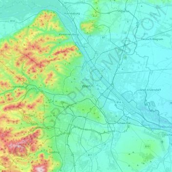
Name: Vienna topographic map, elevation, terrain.
Location: Vienna, 1010, Austria (48.04835 16.21250 48.36835 16.53250)
Average elevation: 231 m
Minimum elevation: 145 m
Maximum elevation: 650 m
Make a donation
Gear up for your next adventure:
As an Amazon Associate, this site earns from qualifying purchases at no extra cost to you.
Other topographic maps
Click on a map to view its topography, its elevation and its terrain.
Vienna
Vienna is located in northeastern Austria, at the easternmost extension of the Alps in the Vienna Basin. The earliest settlement, at the location of today's inner city, was south of the meandering Danube while the city now spans both sides of the river. Elevation ranges from 151 to 542 m (495 to 1,778 ft). The…
Average elevation: 227 m
Wachau Cultural Landscape
Austria > Lower Austria > Bezirk Krems
The Danube valley in Austria between the cities of Melk and Krems in Lower Austria is called the Wachau. This stretch of the valley includes the hills and the adjacent Dunkelsteiner Wald (Dunkelsteiner Forest) and the southern Waldviertel. The Danube river flows north-northeast from Melk to Dürnstein through…
Average elevation: 486 m
Make a donation
Gear up for your next adventure:
As an Amazon Associate, this site earns from qualifying purchases at no extra cost to you.
Vienna
Vienna is located in northeastern Austria, at the easternmost extension of the Alps in the Vienna Basin. The earliest settlement, at the location of today's inner city, was south of the meandering Danube while the city now spans both sides of the river. Elevation ranges from 151 to 542 m (495 to 1,778 ft). The…
Average elevation: 227 m
Make a donation
Gear up for your next adventure:
As an Amazon Associate, this site earns from qualifying purchases at no extra cost to you.
Schärding
Austria > Upper Austria > Bezirk Schärding
The town sits at an altitude of 313 meters and is located in the Innviertel. It measures 4.1 kilometers from north to south, 1.9 km from west to east. The total area is 4.08 km². 2.4 percent of the area is forested, 31.7 percent is used for agriculture.
Average elevation: 323 m
Make a donation
Gear up for your next adventure:
As an Amazon Associate, this site earns from qualifying purchases at no extra cost to you.
Kaprun
Austria > Salzburg > Bezirk Zell am See
Kaprun (German pronunciation: [kaˈpruːn]) is a municipality in the Zell am See District in the province of Salzburg in Austria. Together with the neighboring city of Zell am See the town presents itself as the tourist destination and skiing area "Zell am See-Kaprun". Kaprun distinguishes itself from its…
Average elevation: 1,819 m
Make a donation
Gear up for your next adventure:
As an Amazon Associate, this site earns from qualifying purchases at no extra cost to you.
Make a donation
Gear up for your next adventure:
As an Amazon Associate, this site earns from qualifying purchases at no extra cost to you.
Hall in Tirol
Austria > Tyrol > Bezirk Innsbruck-Land
Hall in Tirol is a town in the Innsbruck-Land district of Tyrol, Austria. Located at an altitude of 574 m, about 5 km (3 mi) east of the state's capital Innsbruck in the Inn valley, it has a population of 14,771 (Dec 2023).
Average elevation: 648 m
Make a donation
Gear up for your next adventure:
As an Amazon Associate, this site earns from qualifying purchases at no extra cost to you.
2641
Austria > Lower Austria > Bezirk Neunkirchen > Schottwien > Maria Schutz
Average elevation: 905 m
Make a donation
Gear up for your next adventure:
As an Amazon Associate, this site earns from qualifying purchases at no extra cost to you.
Steyr
The city is situated in the Traunviertel region, with the two rivers Steyr and Enns flowing through it and meeting near the town centre beneath Lamberg Castle and St Michael's Church. This prominent location has made it prone to severe flooding through the centuries until the present, one of the worst cases…
Average elevation: 341 m
Make a donation
Gear up for your next adventure:
As an Amazon Associate, this site earns from qualifying purchases at no extra cost to you.
Perchtoldsdorfer Heide
Austria > Lower Austria > Bezirk Mödling > Perchtoldsdorf
Average elevation: 312 m
Make a donation
Gear up for your next adventure:
As an Amazon Associate, this site earns from qualifying purchases at no extra cost to you.
Make a donation
Gear up for your next adventure:
As an Amazon Associate, this site earns from qualifying purchases at no extra cost to you.
Hinterstoder
Austria > Upper Austria > Bezirk Kirchdorf
Hinterstoder is a municipality in the district of Kirchdorf an der Krems, in the Austrian state of Upper Austria. The village lies on the southern edge of the district near the border with Styria, at an altitude of around 600 m. Surrounded by the limestone peaks of the Totes Gebirge range, including the…
Average elevation: 1,283 m
Make a donation
Gear up for your next adventure:
As an Amazon Associate, this site earns from qualifying purchases at no extra cost to you.
Lechquellengebirge
Austria > Vorarlberg > Bezirk Bludenz
The use of high-altitude roads (tolls) allows the motor vehicle to penetrate the interior of the mountains to a height of almost 2000 meters. But there are also larger areas with marked seclusion.
Average elevation: 1,568 m
Make a donation
Gear up for your next adventure:
As an Amazon Associate, this site earns from qualifying purchases at no extra cost to you.
Make a donation
Gear up for your next adventure:
As an Amazon Associate, this site earns from qualifying purchases at no extra cost to you.
Graz
Graz is situated on both sides of the river Mur in southeast Austria. It is about 150 km (93 mi) southwest of Vienna (Wien). The nearest larger urban centre is Maribor (Marburg) in Slovenia, which is about 50 km (31 mi) to the south. Graz is the capital of Styria and the largest city in the federal state, a…
Average elevation: 426 m
Make a donation
Gear up for your next adventure:
As an Amazon Associate, this site earns from qualifying purchases at no extra cost to you.
Hallstatt
Austria > Upper Austria > Bezirk Gmunden
The Hallstatt salt mine is the world's oldest working salt mine. The mine is located within the Upper Permian to Lower Triassic Haselgebirge Formation of the Northern Limestone Alps. The Hallstatt salt mine comprises 21 levels and several smaller shafts ranging from 514 m above sea level (Erbstollen level) to…
Average elevation: 1,514 m
Make a donation
Gear up for your next adventure:
As an Amazon Associate, this site earns from qualifying purchases at no extra cost to you.
Kaprun
Austria > Salzburg > Bezirk Zell am See
Kaprun (German pronunciation: [kaˈpruːn]) is a municipality in the Zell am See District in the province of Salzburg in Austria. Together with the neighboring city of Zell am See the town presents itself as the tourist destination and skiing area "Zell am See-Kaprun". Kaprun distinguishes itself from its…
Average elevation: 1,819 m
Sankt Margarethen im Burgenland
Austria > Burgenland > Bezirk Eisenstadt-Umgebung
Average elevation: 164 m
Make a donation
Gear up for your next adventure:
As an Amazon Associate, this site earns from qualifying purchases at no extra cost to you.
Make a donation
Gear up for your next adventure:
As an Amazon Associate, this site earns from qualifying purchases at no extra cost to you.
Damüls
Austria > Vorarlberg > Bezirk Bregenz
Damüls is situated at an altitude of 1,430 m. It has an area of 20.92 km². It borders on the Bregenz Forest, the Biosphere Reserve Großes Walsertal, the Laternsertal, and all other Vorarlberg districts (Bludenz, Feldkirch and Dornbirn). The most famous mountain peak in the area, a popular hiking destination…
Average elevation: 1,608 m
Make a donation
Gear up for your next adventure:
As an Amazon Associate, this site earns from qualifying purchases at no extra cost to you.
Neukirchen am Großvenediger
Austria > Salzburg > Bezirk Zell am See
Neukirchen am Großvenediger is a market town in the district of Zell am See (Pinzgau region), in the state of Salzburg in Austria. Neukirchen is at an altitude of 856 meters and its population (as of May 2001) is 2,616.
Average elevation: 1,968 m
Sölden
Austria > Tyrol > Bezirk Imst
The main village of Sölden is at an elevation of 1,368 metres (4,488 ft) above sea level, and the upper village of Hochsölden at 2,090 m (6,857 ft) has 5 four-star hotels. The highest peak is the Wildspitze, at 3,768 m (12,362 ft), the second highest mountain in Austria, after the Großglockner.
Average elevation: 2,483 m
Make a donation
Gear up for your next adventure:
As an Amazon Associate, this site earns from qualifying purchases at no extra cost to you.
Make a donation
Gear up for your next adventure:
As an Amazon Associate, this site earns from qualifying purchases at no extra cost to you.