Geolocate

Bradley County topographic map

Interactive map

Click on the map to display elevation.

Bradley County

A Topographic map of Bradley County is at https://en-us.topographic-map.com/maps/ettn/Bradley-County/

Wikipedia (CC-BY-SA 3.0)

About this map

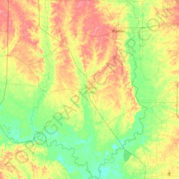
Name: Bradley County topographic map, elevation, terrain.

Location: Bradley County, Arkansas, United States (33.16114 -92.38246 33.70775 -91.95970)

Average elevation: 47 m

Minimum elevation: 15 m

Maximum elevation: 99 m

Other topographic maps

Click on a map to view its topography, its elevation and its terrain.

Wolf Pinnacle

United States > Arkansas > Saline County

Average elevation: 297 m

Whitaker Point

United States > Arkansas > Newton County

Average elevation: 571 m

Buffalo City

United States > Arkansas > Baxter County

Average elevation: 176 m

Ryker

United States > Arkansas > Newton County

Average elevation: 641 m

Magazine Mountain

United States > Arkansas > Logan County

Mount Magazine is often called "the highest point between the Alleghenies and the Rockies" (there are mountains located in the Trans-Pecos region of far-west Texas which exceed Mount Magazine in elevation and prominence, although the Trans-Pecos region lies so far south of the Rockies, that region arguably…

Average elevation: 670 m

Pinnacle

United States > Arkansas > Washington County

Average elevation: 360 m

Petit Jean

United States > Arkansas > Yell County

Average elevation: 108 m

Petit Jean

United States > Arkansas > Yell County

Average elevation: 108 m

Moreland

United States > Arkansas > Pope County

Average elevation: 236 m

Brister

United States > Arkansas > Columbia County

Average elevation: 83 m

Canehill

United States > Arkansas > Washington County

Average elevation: 446 m

Hensley

United States > Arkansas > Pulaski County > Hensley

Average elevation: 75 m

Crosses

United States > Arkansas > Madison County

Average elevation: 490 m

Fox

United States > Arkansas > Stone County

Average elevation: 407 m

Briar

United States > Arkansas > Howard County

Average elevation: 152 m

Witter

United States > Arkansas > Madison County

Average elevation: 494 m

Glory Hole

United States > Arkansas > Newton County

Average elevation: 590 m

Sonora

United States > Arkansas > Washington County

Average elevation: 388 m

River Mountain

United States > Arkansas > Logan County

Average elevation: 257 m

Kirby

United States > Arkansas > Pike County

Average elevation: 198 m

Ben Hur

United States > Arkansas > Newton County

Average elevation: 501 m

Sills

United States > Arkansas > Yell County

Average elevation: 128 m

Forum

United States > Arkansas > Madison County

Average elevation: 454 m

Durham

United States > Arkansas > Washington County

Average elevation: 411 m

Wayton

United States > Arkansas > Newton County

Average elevation: 561 m

Bass

United States > Arkansas > Newton County

Average elevation: 322 m

Strickler

United States > Arkansas > Washington County

Average elevation: 486 m

Greenfield

United States > Arkansas > Poinsett County

Average elevation: 87 m

Columbus

United States > Arkansas > Hempstead County

Average elevation: 123 m

Cord

United States > Arkansas > Independence County

Average elevation: 93 m

Price Place

United States > Arkansas > Marion County

Average elevation: 219 m

Patrick

United States > Arkansas > Madison County

Average elevation: 479 m

Ponca

United States > Arkansas > Newton County

Average elevation: 443 m

Peppers Lake

United States > Arkansas > Prairie County

Average elevation: 64 m

Alma

United States > Arkansas > Crawford County

Average elevation: 167 m

Hagarville

United States > Arkansas > Johnson County

Average elevation: 173 m

Delmar

United States > Arkansas > Carroll County

Average elevation: 535 m

Carryville

United States > Arkansas > Clay County

Average elevation: 83 m

Kimberley

United States > Arkansas > Pike County > Murfreesboro

Average elevation: 106 m

Gavin

United States > Arkansas > Crittenden County > Marion

Average elevation: 67 m

Avilla

United States > Arkansas > Saline County

Average elevation: 154 m

Hogeye

United States > Arkansas > Washington County

Average elevation: 414 m

De Queen Dam

United States > Arkansas > Sevier County

Average elevation: 144 m

Monte Ne Shores

United States > Arkansas > Benton County

Average elevation: 380 m

Shady Grove

United States > Arkansas > Baxter County

Average elevation: 214 m

Fouke

United States > Arkansas > Miller County

Average elevation: 86 m

Mount Nebo

United States > Arkansas > Yell County

Average elevation: 351 m

Lono

United States > Arkansas > Hot Spring County

Average elevation: 141 m

Joplin

United States > Arkansas > Montgomery County

Average elevation: 231 m

Tulip

United States > Arkansas > Dallas County

Average elevation: 132 m

Natural Dam

United States > Arkansas > Crawford County

Average elevation: 246 m

Jones Mills

United States > Arkansas > Hot Spring County

Average elevation: 120 m

Smyrna

United States > Arkansas > Pope County

Average elevation: 402 m

Pruitt

United States > Arkansas > Newton County

Average elevation: 300 m

Center Ridge

United States > Arkansas > Conway County

Average elevation: 211 m

Scotland

United States > Arkansas > Van Buren County

Average elevation: 242 m

Bill Hill

United States > Arkansas > Independence County

Average elevation: 127 m

Indian

United States > Arkansas > Chicot County

Average elevation: 38 m

Vallier

United States > Arkansas > Arkansas County

Average elevation: 57 m

Madison County

United States > Arkansas

Average elevation: 476 m

Maysville

United States > Arkansas > Benton County

Average elevation: 323 m

Ratio

United States > Arkansas > Phillips County

Average elevation: 49 m

Brittain

United States > Arkansas > Pulaski County > Little Rock

Average elevation: 86 m

Half Moon

United States > Arkansas > Mississippi County

Average elevation: 74 m

Big Fork

United States > Arkansas > Polk County

Average elevation: 353 m

Osage

United States > Arkansas > Carroll County

Average elevation: 465 m

Kingston

United States > Arkansas > Yell County

Average elevation: 146 m

Prairie Creek

United States > Arkansas > Benton County > Rogers

Average elevation: 389 m

Cane Hill

United States > Arkansas > Bradley County

Average elevation: 25 m

Bentonville

United States > Arkansas > Benton County > Bentonville > Bentonville

Bentonville lies in the humid subtropical climate zone (Köppen Cfa) with influence from the humid continental climate type. Bentonville experiences all four seasons and does receive cold air masses from the north, however some of the Arctic masses are blocked by the higher elevations of the Ozarks. July is…

Average elevation: 383 m

Bella Vista

United States > Arkansas > Bella Vista > Bella Vista

Average elevation: 359 m

Compton

United States > Arkansas > Newton County

Average elevation: 635 m

Bear

United States > Arkansas > Garland County

Average elevation: 216 m