
La Atalaya topographic map
Interactive map
Click on the map to display elevation.
About this map
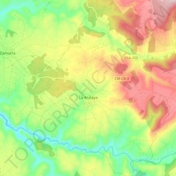
Name: La Atalaya topographic map, elevation, terrain.
Location: La Atalaya, Salamanca, Castile and León, Spain (40.47431 -6.44397 40.53852 -6.37475)
Average elevation: 809 m
Minimum elevation: 660 m
Maximum elevation: 988 m
Other topographic maps
Click on a map to view its topography, its elevation and its terrain.
Yacimiento arqueológico La Edrada
Spain > Castile and León > El Bierzo > Cacabelos
Average elevation: 493 m
Poblado del Salto de Aldeadávila
Spain > Castile and León > Aldeadávila de la Ribera
Average elevation: 535 m
Castrillo Mota de Judíos
Spain > Castile and León > Castrillo Mota de Judíos > Castrillo Mota de Judíos
Average elevation: 801 m