
Arapiles topographic map
Interactive map
Click on the map to display elevation.
About this map
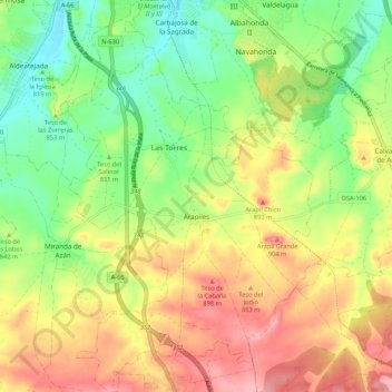
Name: Arapiles topographic map, elevation, terrain.
Location: Arapiles, Salamanca, Castile and León, Spain (40.85779 -5.68240 40.93828 -5.61139)
Average elevation: 842 m
Minimum elevation: 785 m
Maximum elevation: 908 m
Other topographic maps
Click on a map to view its topography, its elevation and its terrain.
Yacimiento arqueológico La Edrada
Spain > Castile and León > El Bierzo > Cacabelos
Average elevation: 493 m
Poblado del Salto de Aldeadávila
Spain > Castile and León > Aldeadávila de la Ribera
Average elevation: 535 m
Castrillo Mota de Judíos
Spain > Castile and León > Castrillo Mota de Judíos > Castrillo Mota de Judíos
Average elevation: 801 m