
Murang'a County topographic map
Click on the map to display elevation.
About this map
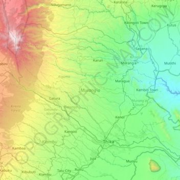
Name: Murang'a County topographic map, elevation, terrain.
Location: Murang'a County, Kenya (-1.09604 36.70649 -0.56733 37.42133)
Average elevation: 1,751 m
Minimum elevation: 1,046 m
Maximum elevation: 3,859 m
Other topographic maps
Click on a map to view its topography, its elevation and its terrain.
Kisumu
Kisumu literally means a place of barter trade "sumo". The city has "Friendship" status with Cheltenham, United Kingdom and "sister city" status with Roanoke, Virginia and Boulder, Colorado, United States. It sits at an elevation of 1,131 m (3,711 ft). Kisumu is 200 miles north west of Nairobi and its located…
Average elevation: 1,219 m
Mombasa
Being a coastal town, Mombasa is characterised by a flat topography. The town of Mombasa is centred on Mombasa Island, but extends to the mainland. The island is separated from the mainland by two creeks, Port Reitz in the south and Tudor Creek in the north.
Average elevation: 18 m
Nairobi
Kenya > Nairobi County > Starehe
Nairobi was founded in 1899 by colonial authorities in British East Africa, as a rail depot on the Uganda - Kenya Railway. It was favoured by the authorities as an ideal resting place due to its high elevation, temperate climate, and adequate water supply. The town quickly grew to replace Mombasa as the…
Average elevation: 1,724 m
Kijabe
Kenya > Kiambu > Lari > Kinale ward
It stands on the edge of the Great Rift Valley at an altitude of 2200m, some 50 kilometres north-west of Nairobi. Kijabe is located in the sub-county of Lari, Kiambu County. Kijabe has a population 2,026 in 2019. Kijabe has a railway station along the Uganda Railway. The town is located between Limuru and…
Average elevation: 2,311 m
Ruiru
Ruiru is located about 20 kilometres (12 mi), by road, northeast of the central business district of Nairobi, the nation's capital city. The subcounty measures 292 km2 (113 sq mi) and is connected to Nairobi by both road and rail. The geographical co-ordinates of Ruiru are: 1°10'04.0"S, 36°58'24.0"E…
Average elevation: 1,529 m
Narok
Narok (sometimes referred to as Narok Town) is a town west of Nairobi that supports Kenya's economy in south-west of the country, along the Great Rift Valley. Narok is the district capital of the Narok County and stands as the major centre of commerce in the district. Narok has a population of around 40,000…
Average elevation: 1,904 m
Eldoret
Kenya > Uasin Gishu > Eldoret
Eldoret is a principal town in the Rift Valley region of Kenya and serves as the capital of Uasin Gishu County. The town is colloquially known as 'Chebarbar', a parody name from the Chebarbar River that lies about 7 kilometers from Kapsabet town, on the main highway to the town of Eldoret. As per the 2019…
Average elevation: 2,111 m
Marua
Kenya > Nyeri > Nyeri Central
The climate of Central Province is generally cooler than that of the rest of Kenya, due to the region's higher altitude. Rainfall is fairly reliable, falling in two seasons, one from early March to May (the long rains) and a second during October and November (the short rains).
Average elevation: 1,692 m
Kitenden B Community Conservancy
Kenya > Kajiado County > Loitokitok > Etonet/Lenkism ward
Average elevation: 1,468 m
Kitale
Kenya > Trans Nzoia > Kitale
Kitale is an agricultural town in northern Rift Valley Kenya situated between Mount Elgon and the Cherangany Hills at an elevation of around 1,900 metres (6,200 ft). Its population is 106,187 as of 2009.. Kitale is the headquarter town of Trans-Nzoia County. Kitale is reachable by air through Kitale Airport.…
Average elevation: 1,852 m
Mount Kenya
The glaciers on Mount Kenya are retreating rapidly. The Mountain Club of Kenya in Nairobi has photographs showing the mountain at the time of the first recorded ascent in 1899, and again more recently; the retreat of the glaciers is very evident. Descriptions of ascents of several of the peaks advise the use…
Average elevation: 4,556 m
Ruiru
Kenya > Kiambu > Ruiru > Biashara ward
Ruiru is about 20 kilometres (12 mi) by road northeast of the central business district of Nairobi, the nation's capital city. The sub-county measures 292 km2 (113 sq mi) and is connected to Nairobi by road and rail. The geographical coordinates of Ruiru are 1°10'04.0"S, 36°58'24.0" E (Latitude: −1.167778;…
Average elevation: 1,531 m
Murang'a
Kenya > Murang'a County > Kiharu
The town is low, a bit hilly, small but picturesque with an altitude of 4120 ft (1255 metres) above sea level. As a result of the varying altitudes, Murang'a can get quite cold from May to mid-August, and can experience hail. To the west of the town can be seen the rolling Kikuyu farmlands that extend as far…
Average elevation: 1,286 m
Ngong
Kenya > Kajiado County > Kajiado North > Ngong ward
As of 2019, the population of Ngong Town consisting of Enchorro-Emunyi and Ngong Township locations is 25,866. The elevation of Ngong town is 1,961 meters in altitude, but the altitude of the hills is about 2,460 meters above sea level. Ngong was the central town of Ngong division while Kajiado County was a…
Average elevation: 1,951 m
Limuru
Most of the area of Limuru is now what was previously known as the "white highlands", a rich agricultural land south of the equator. The term "white highlands" derived from the British and other Europeans who realised the productive potential of this area and settled in large numbers with the support of the…
Average elevation: 2,254 m
Kitale
Kenya > Trans-Nzoia County > Saboti
Kitale is a town in the north west of Kenya, in the old Rift Valley province. It situated between Mount Elgon and the Cherangany Hills. The town has an elevation of around 1,900 metres (6,200 ft). Its population was 162,174 as of 2019. Kitale town is the headquarter of the Trans-Nzoia County, which is also…
Average elevation: 1,849 m
Nyahururu
Kenya > Laikipia County > Laikipia West
Nyahururu is also frequented by marathon and cross-country runners for practicing before major events due to its high altitude.
Average elevation: 2,348 m
Kakamega
Kakamega is 52 km north of Kisumu, the tenth largest city in Kenya and considered the heart of Luhya land. The average elevation of Kakamega is 1,535 metres.
Average elevation: 1,533 m
Nairobi National Park
Kenya > Nairobi County > Kajiado North > Nairobi
The park covers an area of 117.21 km2 (45.26 sq mi) and is small in comparison to most of Africa's national parks. The park's altitude ranges between 1,533 and 1,760 m (5,030 and 5,774 ft). It has a dry climate. The park is the only protected part of the Athi-Kapiti ecosystem, making up less than 10% of this…
Average elevation: 1,662 m
Kibera
Kenya > Nairobi County > Kambi Muru
The third complicating factor is the unyielding topography and cramped sprawl of the area. Few houses have vehicle access, and many are at the bottoms of steep inclines (which heightens the flooding risk). This means that any construction efforts are made more difficult and costly by the fact that all…
Average elevation: 1,735 m
Narok
Kenya > Narok > Narok North > Narok Town ward
Narok (sometimes referred to as NauwongoTown) is a town west of Nairobi that supports Kenya's economy in south-west of the country, along the Great Rift Valley. Narok is the county capital of the Narok County and stands as the major centre of commerce in the county. Narok has a population of around 117, 607…
Average elevation: 1,920 m
Mount Kenya
The glaciers on Mount Kenya are retreating rapidly. The Mountain Club of Kenya in Nairobi has photographs showing the mountain at the time of the first recorded ascent in 1899, and again more recently; the retreat of the glaciers is very evident. Descriptions of ascents of several of the peaks advise the use…
Average elevation: 4,556 m
Eldoret
Kenya > Uasin Gishu County > Moiben
Eldoret is a principal town in the Rift Valley region of Kenya and serves as the capital of Uasin Gishu County. The town was referred to by white settlers as Farm 64, 64 and colloquially by locals as 'Sisibo'. As per the 2019 Kenya Population and Housing Census, Eldoret is the fifth most populated urban area…
Average elevation: 2,093 m